5-Day Uncertainty Track last updated Fri, 17 Nov 2023 23:46:24 GMT

Wind Speed Probabilities last updated Fri, 17 Nov 2023 21:22:28 GMT
NHC Hurricane Advisories
5-Day Uncertainty Track last updated Fri, 17 Nov 2023 23:46:24 GMT
Wind Speed Probabilities last updated Fri, 17 Nov 2023 21:22:28 GMT
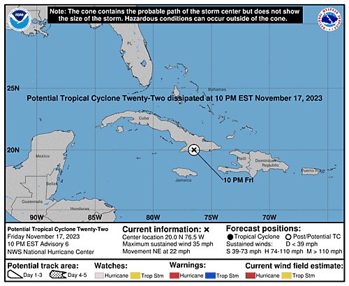
Issued at 700 PM EST Fri Nov 17 2023
000
WTNT32 KNHC 172346
TCPAT2

BULLETIN
Potential Tropical Cyclone Twenty-Two
Intermediate Advisory Number 5A
NWS National Hurricane Center Miami FL       AL222023
700 PM EST Fri Nov 17 2023

...DISTURBANCE UNLIKELY TO BECOME A TROPICAL CYCLONE...
...STILL A SIGNIFICANT RISK OF LIFE-THREATENING FLASH FLOODING AND
MUDSLIDES ACROSS JAMAICA, HISPANIOLA, AND SOUTHEASTERN CUBA...


SUMMARY OF 700 PM EST...0000 UTC...INFORMATION
----------------------------------------------
LOCATION...19.4N 77.1W
ABOUT 85 MI...135 KM NE OF MONTEGO BAY JAMAICA
ABOUT 140 MI...225 KM WSW OF GUANTANAMO CUBA
MAXIMUM SUSTAINED WINDS...35 MPH...55 KM/H
PRESENT MOVEMENT...NE OR 45 DEGREES AT 17 MPH...28 KM/H
MINIMUM CENTRAL PRESSURE...1005 MB...29.68 INCHES


WATCHES AND WARNINGS
--------------------
CHANGES WITH THIS ADVISORY:

The government of Cuba has discontinued the Tropical Storm Watch for
eastern Cuba. The government of the Bahamas has discontinued the
Tropical Storm Watch for the southeastern Bahamas and the Turks and
Caicos Islands.

SUMMARY OF WATCHES AND WARNINGS IN EFFECT:

A Tropical Storm Watch is in effect for...
* Haiti

A Tropical Storm Watch means that tropical storm conditions are
possible within the watch area.

For storm information specific to your area, please monitor products
issued by your national meteorological service.


DISCUSSION AND OUTLOOK
----------------------
At 700 PM EST (0000 UTC), the disturbance was centered near latitude
19.4 North, longitude 77.1 West. The system is moving toward the
northeast near 17 mph (28 km/h), and an acceleration toward the
northeast is expected through the weekend. On the forecast track,
the system is expected to move across southeastern Cuba tonight and
the southeastern Bahamas and the Turks and Caicos Islands Saturday
morning.

Maximum sustained winds are near 35 mph (55 km/h) with higher gusts.
Some slight strengthening is possible during the next couple of
days, but the system's chance of becoming a tropical cyclone is
decreasing.
* Formation chance through 48 hours...low ...20 percent.
* Formation chance through 7 days...low...20 percent.

The estimated minimum central pressure is 1005 mb (29.68 inches).


HAZARDS AFFECTING LAND
----------------------
Key messages for Potential Tropical Cyclone Twenty-Two can be found
in the Tropical Cyclone Discussion under AWIPS header MIATCDAT2 and
WMO header WTNT42 KNHC, and on the web at
hurricanes.gov/text/MIATCDAT2.shtml

WIND:  Tropical storm conditions are possible, especially in areas
of heavy rain, across Haiti through tonight.

RAINFALL:  Potential Tropical Cyclone Twenty-Two is expected to
produce additional total rainfall of 4 to 8 inches with maximum
amounts of 16 inches across portions of Jamaica, southeast Cuba, and
southern Hispaniola through Sunday. These rains are likely to
produce flash flooding, along with mudslides in areas of higher
terrain.

The system is expected to produce 2 to 4 inches of rainfall across
the southeastern Bahamas as well as the Turks and Caicos Islands.
This rainfall may lead to flash flooding in urban areas.

STORM SURGE:  Minor coastal flooding is possible in areas of
onshore winds along the southeastern coast of Cuba, the southeastern
Bahamas, and the Turks and Caicos Islands.

SURF:  Swells generated by the disturbance are expected to affect
portions of Jamaica, Haiti, and southeastern Cuba through Saturday.
These swells are likely to cause life-threatening surf and rip
current conditions. Please consult products from your local weather
office.


NEXT ADVISORY
-------------
Next complete advisory at 1000 PM EST.

$$
Forecaster Reinhart
5-Day Uncertainty Track last updated Fri, 17 Nov 2023 21:22:27 GMT
Wind Speed Probabilities last updated Fri, 17 Nov 2023 21:22:28 GMT
Issued at 2100 UTC FRI NOV 17 2023
000
FONT12 KNHC 172051
PWSAT2

POTENTIAL TROPICAL CYCLONE TWENTY-TWO
WIND SPEED PROBABILITIES NUMBER   5
NWS NATIONAL HURRICANE CENTER MIAMI FL       AL222023
2100 UTC FRI NOV 17 2023

AT 2100Z THE CENTER OF POTENTIAL TROPICAL CYCLONE TWENTY-TWO WAS
LOCATED NEAR LATITUDE 18.7 NORTH...LONGITUDE 77.7 WEST WITH MAXIMUM
SUSTAINED WINDS NEAR 30 KTS...35 MPH...55 KM/H.

Z INDICATES COORDINATED UNIVERSAL TIME (GREENWICH)
   ATLANTIC STANDARD TIME (AST)...SUBTRACT 4 HOURS FROM Z TIME
   EASTERN  STANDARD TIME (EST)...SUBTRACT 5 HOURS FROM Z TIME
   CENTRAL  STANDARD TIME (CST)...SUBTRACT 6 HOURS FROM Z TIME

WIND SPEED PROBABILITY TABLE FOR SPECIFIC LOCATIONS

CHANCES OF SUSTAINED (1-MINUTE AVERAGE) WIND SPEEDS OF AT LEAST
   ...34 KT (39 MPH... 63 KM/H)...
   ...50 KT (58 MPH... 93 KM/H)...
   ...64 KT (74 MPH...119 KM/H)...
FOR LOCATIONS AND TIME PERIODS DURING THE NEXT 5 DAYS

PROBABILITIES FOR LOCATIONS ARE GIVEN AS OP(CP) WHERE
    OP  IS THE PROBABILITY OF THE EVENT BEGINNING DURING
        AN INDIVIDUAL TIME PERIOD (ONSET PROBABILITY)
   (CP) IS THE PROBABILITY OF THE EVENT OCCURRING BETWEEN
        18Z FRI AND THE FORECAST HOUR (CUMULATIVE PROBABILITY)

PROBABILITIES ARE GIVEN IN PERCENT
X INDICATES PROBABILITIES LESS THAN 1 PERCENT
PROBABILITIES FOR 34 KT AND 50 KT ARE SHOWN AT A GIVEN LOCATION WHEN
THE 5-DAY CUMULATIVE PROBABILITY IS AT LEAST 3 PERCENT.
PROBABILITIES FOR 34...50...64 KT SHOWN WHEN THE 5-DAY
64-KT CUMULATIVE PROBABILITY IS AT LEAST 1 PERCENT.


  - - - - WIND SPEED PROBABILITIES FOR SELECTED LOCATIONS - - - -

               FROM    FROM    FROM    FROM    FROM    FROM    FROM
  TIME       18Z FRI 06Z SAT 18Z SAT 06Z SUN 18Z SUN 18Z MON 18Z TUE
PERIODS         TO      TO      TO      TO      TO      TO      TO
             06Z SAT 18Z SAT 06Z SUN 18Z SUN 18Z MON 18Z TUE 18Z WED

FORECAST HOUR    (12)   (24)    (36)    (48)    (72)    (96)   (120)
- - - - - - - - - - - - - - - - - - - - - - - - - - - - - - - - - -
LOCATION       KT

MAYAGUANA      34  X  15(15)   X(15)   X(15)   X(15)   X(15)   X(15)

GRAND TURK     34  X   6( 6)   X( 6)   X( 6)   X( 6)   X( 6)   X( 6)

$$
FORECASTER BERG
Issued at 400 PM EST Fri Nov 17 2023
000
WTNT42 KNHC 172051
TCDAT2

Potential Tropical Cyclone Twenty-Two Discussion Number   5
NWS National Hurricane Center Miami FL       AL222023
400 PM EST Fri Nov 17 2023

The disturbance continues to have a broad and elongated circulation
with a vorticity maximum in the vicinity of western Jamaica and all
of the associated deep convection east of the trough axis.  Earlier
ASCAT passes differed on the strength of the system's winds, with
the B instrument showing 35-40 kt within the Jamaica Channel and the
C instrument only showing 25-30 kt.  The intensity remains 30 kt
based on a blend of these data.

The system is accelerating northeastward with an initial motion of
050/15 kt.  An additional acceleration toward the northeast--close
to 30 kt by 36-48 hours--is expected as the disturbance gets picked
up by a shortwave trough moving across Florida toward the
southwestern Atlantic.  The updated NHC forecast remains near the
fastest model solutions, and is generally a blend of the previous
forecast with the latest GFS model.  As noted earlier, the
disturbance's motion across the Greater Antilles is likely to be
discontinuous.

The chance for the system to become a tropical cyclone continues to
decrease and in fact now appears unlikely due to a combination of
the system's broad structure, the terrain of the Greater Antilles,
strong southwesterly shear, and mid-level dry air.  However, with
the strongest surface winds near or just below 35 kt, there is
still some chance that the system could produce
tropical-storm-force winds over areas within the tropical storm
watch, especially within heavy rainfall.  The NHC forecast still
shows the possibility, albeit small, for the system to become a
tropical storm in 24-36 hours mainly based on continuity.  After
that, the system should become extratropical by 48 hours and
absorbed by a front by 60 hours.  Advisories on this system could be
discontinued at any time if there is no longer a risk of
tropical-storm-force winds within the tropical storm watch areas.

Despite the decreasing chance of tropical cyclone formation, there
is high confidence that heavy rainfall and flooding will remain a
distinct and serious threat across Jamaica, southeastern Cuba, and
Hispaniola.  Additional rainfall amounts of 4 to 8 inches, with
isolated areas as high as 16 inches, are forecast in these areas
and are likely to produce life-threatening flash flooding and
mudslides.


KEY MESSAGES:

1.  Potential Tropical Cyclone Twenty-Two could produce tropical
storm conditions, especially in areas of heavy rainfall, across
southeastern Cuba, Haiti, the southeastern Bahamas, and the Turks
and Caicos Islands through Saturday, and tropical storm watches are
in effect for these areas.

2.  Heavy rains will impact portions of Jamaica, southeast Cuba, and
southern Hispaniola through Sunday. This rainfall is likely to
produce flash flooding, along with mudslides in areas of higher
terrain.  Lighter amounts across the southeastern Bahamas as
well as the Turks and Caicos Islands may lead to flash flooding in
urban areas.


FORECAST POSITIONS AND MAX WINDS

INIT  17/2100Z 18.7N  77.7W   30 KT  35 MPH...POTENTIAL TROP CYCLONE
 12H  18/0600Z 20.7N  75.3W   30 KT  35 MPH...POTENTIAL TROP CYCLONE
 24H  18/1800Z 23.4N  71.3W   35 KT  40 MPH...TROPICAL STORM
 36H  19/0600Z 26.5N  66.0W   35 KT  40 MPH
 48H  19/1800Z 30.1N  60.8W   35 KT  40 MPH...POST-TROP/EXTRATROP
 60H  20/0600Z...ABSORBED BY A FRONT

$$
Forecaster Berg
5-Day Uncertainty Track last updated Fri, 17 Nov 2023 20:52:29 GMT
Wind Speed Probabilities last updated Fri, 17 Nov 2023 20:52:30 GMT
Issued at 400 PM EST Fri Nov 17 2023
398
WTNT32 KNHC 172050
TCPAT2

BULLETIN
Potential Tropical Cyclone Twenty-Two Advisory Number   5
NWS National Hurricane Center Miami FL       AL222023
400 PM EST Fri Nov 17 2023

...DISTURBANCE IS NOT LIKELY TO BECOME A TROPICAL CYCLONE...
...BUT THE RISK OF LIFE-THREATENING FLASH FLOODING AND MUDSLIDES
ACROSS JAMAICA, HISPANIOLA, AND SOUTHEASTERN CUBA CONTINUES...


SUMMARY OF 400 PM EST...2100 UTC...INFORMATION
----------------------------------------------
LOCATION...18.7N 77.7W
ABOUT 20 MI...30 KM NE OF MONTEGO BAY JAMAICA
ABOUT 195 MI...310 KM WSW OF GUANTANAMO CUBA
MAXIMUM SUSTAINED WINDS...35 MPH...55 KM/H
PRESENT MOVEMENT...NE OR 50 DEGREES AT 17 MPH...28 KM/H
MINIMUM CENTRAL PRESSURE...1004 MB...29.65 INCHES


WATCHES AND WARNINGS
--------------------
CHANGES WITH THIS ADVISORY:

The government of Jamaica has discontinued the Tropical Storm Watch
for Jamaica.

SUMMARY OF WATCHES AND WARNINGS IN EFFECT:

A Tropical Storm Watch is in effect for...
* Haiti
* Cuban provinces of Guantanamo, Santiago de Cuba, Holguin, Granma,
and Las Tunas
* Southeastern Bahamas and Turks and Caicos Islands

A Tropical Storm Watch means that tropical storm conditions are
possible within the watch area, in this case within 24 hours.

For storm information specific to your area, please monitor
products issued by your national meteorological service.


DISCUSSION AND OUTLOOK
----------------------
At 400 PM EST (2100 UTC), the disturbance was centered near latitude
18.7 North, longitude 77.7 West.  The system is moving faster
toward the northeast near 17 mph (28 km/h), and an additional
acceleration toward the northeast is expected through the weekend.
On the forecast track, the system is expected to move across
southeastern Cuba tonight and the southeastern Bahamas and Turks and
Caicos Islands Saturday morning.

Maximum sustained winds are near 35 mph (55 km/h) with higher gusts.
Some slight strengthening is possible during the next couple of
days, but the system's chance of becoming a tropical cyclone appears
to be decreasing.
* Formation chance through 48 hours...low...30 percent.
* Formation chance through 7 days...low...30 percent.

The estimated minimum central pressure is 1004 mb (29.65 inches).


HAZARDS AFFECTING LAND
----------------------
Key messages for Potential Tropical Cyclone Twenty-Two can be found
in the Tropical Cyclone Discussion under AWIPS header MIATCDAT2 and
WMO header WTNT42 KNHC, and on the web at
hurricanes.gov/text/MIATCDAT2.shtml

WIND:  Tropical storm conditions are possible, especially in areas
of heavy rain, across southeastern Cuba and Haiti through tonight,
and over the southeastern Bahamas and Turks and Caicos Islands
on Saturday.

RAINFALL:  Potential Tropical Cyclone Twenty-Two is expected to
produce additional total rainfall of 4 to 8 inches with maximum
amounts of 16 inches across portions of Jamaica, southeast Cuba, and
southern Hispaniola through Sunday. These rains are likely to
produce flash flooding, along with mudslides in areas of higher
terrain.

The system is expected to produce 2 to 4 inches of rainfall across
the southeastern Bahamas as well as the Turks and Caicos Islands.
This rainfall may lead to flash flooding in urban areas.

STORM SURGE:  Minor coastal flooding is possible in areas of
onshore winds along the southeastern coast of Cuba, the southeastern
Bahamas, and the Turks and Caicos Islands.

SURF:  Swells generated by the disturbance are expected to affect
portions of Jamaica, Haiti, and southeastern Cuba through Saturday.
These swells are likely to cause life-threatening surf and rip
current conditions.  Please consult products from your local weather
office.


NEXT ADVISORY
-------------
Next intermediate advisory at 700 PM EST.
Next complete advisory at 1000 PM EST.

$$
Forecaster Berg
Issued at 2100 UTC FRI NOV 17 2023
399
WTNT22 KNHC 172050
TCMAT2

POTENTIAL TROPICAL CYCLONE TWENTY-TWO FORECAST/ADVISORY NUMBER   5
NWS NATIONAL HURRICANE CENTER MIAMI FL       AL222023
2100 UTC FRI NOV 17 2023

NOTICE... LAND-BASED TROPICAL CYCLONE WATCHES AND WARNINGS ARE NO
LONGER INCLUDED IN THE TROPICAL CYCLONE FORECAST/ADVISORY...(TCM).
CURRENT LAND-BASED COASTAL WATCHES AND WARNINGS CAN BE FOUND IN THE
MOST RECENTLY ISSUED TROPICAL CYCLONE PUBLIC ADVISORY...(TCP).

POTENTIAL TROP CYCLONE CENTER LOCATED NEAR 18.7N  77.7W AT 17/2100Z
POSITION ACCURATE WITHIN  60 NM

PRESENT MOVEMENT TOWARD THE NORTHEAST OR  50 DEGREES AT  15 KT

ESTIMATED MINIMUM CENTRAL PRESSURE 1004 MB
MAX SUSTAINED WINDS  30 KT WITH GUSTS TO  40 KT.
12 FT SEAS..  0NE 120SE   0SW   0NW.
WINDS AND SEAS VARY GREATLY IN EACH QUADRANT.  RADII IN NAUTICAL
MILES ARE THE LARGEST RADII EXPECTED ANYWHERE IN THAT QUADRANT.

REPEAT...CENTER LOCATED NEAR 18.7N  77.7W AT 17/2100Z
AT 17/1800Z CENTER WAS LOCATED NEAR 18.0N  78.5W

FORECAST VALID 18/0600Z 20.7N  75.3W...POTENTIAL TROP CYCLONE
MAX WIND  30 KT...GUSTS  40 KT.

FORECAST VALID 18/1800Z 23.4N  71.3W
MAX WIND  35 KT...GUSTS  45 KT.
34 KT... 40NE  50SE   0SW   0NW.

FORECAST VALID 19/0600Z 26.5N  66.0W
MAX WIND  35 KT...GUSTS  45 KT.
34 KT... 50NE  50SE   0SW   0NW.

FORECAST VALID 19/1800Z 30.1N  60.8W...POST-TROP/EXTRATROP
MAX WIND  35 KT...GUSTS  45 KT.
34 KT... 70NE  70SE  40SW   0NW.

FORECAST VALID 20/0600Z...DISSIPATED

REQUEST FOR 3 HOURLY SHIP REPORTS WITHIN 300 MILES OF 18.7N  77.7W

INTERMEDIATE PUBLIC ADVISORY...WTNT32 KNHC/MIATCPAT2...AT 18/0000Z

NEXT ADVISORY AT 18/0300Z

$$
FORECASTER BERG
5-Day Uncertainty Track last updated Fri, 17 Nov 2023 17:40:05 GMT
Wind Speed Probabilities last updated Fri, 17 Nov 2023 15:22:53 GMT
Issued at 100 PM EST Fri Nov 17 2023
000
WTNT32 KNHC 171740
TCPAT2

BULLETIN
Potential Tropical Cyclone Twenty-Two
Intermediate Advisory Number 4A
NWS National Hurricane Center Miami FL       AL222023
100 PM EST Fri Nov 17 2023

...FLOODING RAINS CONTINUE TO SPREAD ACROSS JAMAICA, HISPANIOLA,
AND SOUTHEASTERN CUBA...


SUMMARY OF 100 PM EST...1800 UTC...INFORMATION
----------------------------------------------
LOCATION...18.0N 78.5W
ABOUT 50 MI...85 KM SW OF MONTEGO BAY JAMAICA
ABOUT 265 MI...425 KM SW OF GUANTANAMO CUBA
MAXIMUM SUSTAINED WINDS...35 MPH...55 KM/H
PRESENT MOVEMENT...NE OR 50 DEGREES AT 16 MPH...26 KM/H
MINIMUM CENTRAL PRESSURE...1004 MB...29.65 INCHES


WATCHES AND WARNINGS
--------------------
CHANGES WITH THIS ADVISORY:

None.

SUMMARY OF WATCHES AND WARNINGS IN EFFECT:

A Tropical Storm Watch is in effect for...
* Jamaica
* Haiti
* Cuban provinces of Guantanamo, Santiago de Cuba, Holguin, Granma,
and Las Tunas
* Southeastern Bahamas and Turks and Caicos Islands

A Tropical Storm Watch means that tropical storm conditions are
possible within the watch area, in this case within 24 hours.

For storm information specific to your area, please monitor
products issued by your national meteorological service.


DISCUSSION AND OUTLOOK
----------------------
At 100 PM EST (1800 UTC), the disturbance was centered near latitude
18.0 North, longitude 78.5 West.  The system is moving faster
toward the northeast near 16 mph (26 km/h), and an additional
acceleration toward the northeast is expected through the weekend.
On the forecast track, the system is expected to move across Jamaica
this afternoon, southeastern Cuba by early Saturday, and the
southeastern Bahamas and Turks and Caicos Islands on Saturday.

Maximum sustained winds are near 35 mph (55 km/h) with higher
gusts. Some slight strengthening is possible during the next couple
of days, but the system's chance of becoming a tropical cyclone
appears to be decreasing.
* Formation chance through 48 hours... medium...40 percent.
* Formation chance through 7 days...medium...40 percent.

The estimated minimum central pressure is 1004 mb (29.65 inches).


HAZARDS AFFECTING LAND
----------------------
Key messages for Potential Tropical Cyclone Twenty-Two can be found
in the Tropical Cyclone Discussion under AWIPS header MIATCDAT2 and
WMO header WTNT42 KNHC, and on the web at
hurricanes.gov/text/MIATCDAT2.shtml

WIND:  Tropical storm conditions are possible, especially in areas
of heavy rain, on Jamaica today, southeastern Cuba and Haiti
tonight, and the southeastern Bahamas and Turks and Caicos Islands
on Saturday.

RAINFALL:  Potential Tropical Cyclone Twenty-Two is expected to
produce additional total rainfall of 4 to 8 inches with maximum
amounts of 16 inches across portions of Jamaica, southeast Cuba, and
southern Hispaniola through Sunday. These rains are likely to
produce flash flooding, along with mudslides in areas of higher
terrain.

The system is expected to produce 2 to 4 inches of rainfall across
the southeastern Bahamas as well as the Turks and Caicos Islands.
This rainfall may lead to flash flooding in urban areas.

STORM SURGE:  Minor coastal flooding is possible in areas of
onshore winds along the southeastern coast of Cuba, the southeastern
Bahamas, and the Turks and Caicos Islands.

SURF:  Swells generated by the disturbance are expected to affect
portions of Jamaica, Haiti, and southeastern Cuba during the next
day or so.  These swells are likely to cause life-threatening
surf and rip current conditions.  Please consult products from your
local weather office.


NEXT ADVISORY
-------------
Next complete advisory at 400 PM EST.

$$
Forecaster Berg
Issued at 1000 AM EST Fri Nov 17 2023
763
WTNT42 KNHC 171434
TCDAT2

Potential Tropical Cyclone Twenty-Two Discussion Number   4
NWS National Hurricane Center Miami FL       AL222023
1000 AM EST Fri Nov 17 2023

First-light visible satellite images indicate that the disturbance
is still a surface trough of low pressure with nearly all of the
deep convection to the east of the trough axis streaming northward
across Jamaica, Haiti, and eastern Cuba.  Surface pressures remain
low--about 1004 mb--but the center of circulation is ill defined.
Maximum winds are still estimated to be 30 kt, primarily within the
deep convection.

The system appears to be accelerating northeastward with an initial
motion of 045/12 kt.  A continued northeastward acceleration is
anticipated during the next day or two as the disturbance moves
ahead of a mid-level trough moving across Florida and the far
northwestern Caribbean Sea.  With the circulation being so broad,
however, global model wind fields suggest the system may jump
discontinuously rather than move seamlessly across the Greater
Antilles during the next 24 hours.  The NHC track forecast favors
the faster model solutions and is generally a blend of the previous
forecast with the latest GFS solution.

The prospects for the disturbance to become a tropical cyclone
appear to be decreasing.  The system is already battling strong
southwesterly shear and mid-level dry air, and none of the global
models any longer depicts the development of a well-defined
circulation.  The new NHC forecast therefore keeps the system as a
disturbance through tonight, with some possibility (albeit
decreasing) of the system becoming a tropical depression or
tropical storm after it passes the mountainous terrain of Jamaica
and southeastern Cuba.  In whatever form the system emerges over
the western Atlantic over the weekend, it is likely to become
extratropical or merge with a front over the weekend.

Despite the decreasing chance of tropical cyclone formation, there
is high confidence that heavy rainfall and flooding will remain a
distinct and serious threat across Jamaica, southeastern Cuba, and
Hispaniola.  Additional rainfall amounts of 4 to 8 inches, with
isolated areas as high as 16 inches, are forecast in these areas
and are likely to produce life-threatening flash flooding and
mudslides.


KEY MESSAGES:

1.  Potential Tropical Cyclone Twenty-Two could produce tropical
storm conditions, especially in areas of heavy rainfall, across
Jamaica, southeastern Cuba, Haiti, the southeastern Bahamas, and the
Turks and Caicos Islands through Saturday, and tropical storm
watches are in effect for these areas.

2.  Heavy rains will impact portions of Jamaica, southeastern Cuba,
and southern Hispaniola through Sunday.  This rainfall is likely to
produce flash flooding, along with mudslides in areas of higher
terrain.  Lighter amounts across the southeastern Bahamas as well
as the Turks and Caicos Islands may lead to flash flooding in urban
areas.


FORECAST POSITIONS AND MAX WINDS

INIT  17/1500Z 17.5N  79.1W   30 KT  35 MPH...POTENTIAL TROP CYCLONE
 12H  18/0000Z 19.3N  76.8W   30 KT  35 MPH...POTENTIAL TROP CYCLONE
 24H  18/1200Z 21.9N  73.3W   35 KT  40 MPH...TROPICAL STORM
 36H  19/0000Z 25.2N  68.9W   35 KT  40 MPH
 48H  19/1200Z 28.3N  64.8W   40 KT  45 MPH...POST-TROP/EXTRATROP
 60H  20/0000Z 31.8N  61.0W   40 KT  45 MPH...POST-TROP/EXTRATROP
 72H  20/1200Z...ABSORBED BY A FRONT

$$
Forecaster Berg
Issued at 1500 UTC FRI NOV 17 2023
761
FONT12 KNHC 171434
PWSAT2

POTENTIAL TROPICAL CYCLONE TWENTY-TWO
WIND SPEED PROBABILITIES NUMBER   4
NWS NATIONAL HURRICANE CENTER MIAMI FL       AL222023
1500 UTC FRI NOV 17 2023

AT 1500Z THE CENTER OF POTENTIAL TROPICAL CYCLONE TWENTY-TWO WAS
LOCATED NEAR LATITUDE 17.5 NORTH...LONGITUDE 79.1 WEST WITH MAXIMUM
SUSTAINED WINDS NEAR 30 KTS...35 MPH...55 KM/H.

Z INDICATES COORDINATED UNIVERSAL TIME (GREENWICH)
   ATLANTIC STANDARD TIME (AST)...SUBTRACT 4 HOURS FROM Z TIME
   EASTERN  STANDARD TIME (EST)...SUBTRACT 5 HOURS FROM Z TIME
   CENTRAL  STANDARD TIME (CST)...SUBTRACT 6 HOURS FROM Z TIME

WIND SPEED PROBABILITY TABLE FOR SPECIFIC LOCATIONS

CHANCES OF SUSTAINED (1-MINUTE AVERAGE) WIND SPEEDS OF AT LEAST
   ...34 KT (39 MPH... 63 KM/H)...
   ...50 KT (58 MPH... 93 KM/H)...
   ...64 KT (74 MPH...119 KM/H)...
FOR LOCATIONS AND TIME PERIODS DURING THE NEXT 5 DAYS

PROBABILITIES FOR LOCATIONS ARE GIVEN AS OP(CP) WHERE
    OP  IS THE PROBABILITY OF THE EVENT BEGINNING DURING
        AN INDIVIDUAL TIME PERIOD (ONSET PROBABILITY)
   (CP) IS THE PROBABILITY OF THE EVENT OCCURRING BETWEEN
        12Z FRI AND THE FORECAST HOUR (CUMULATIVE PROBABILITY)

PROBABILITIES ARE GIVEN IN PERCENT
X INDICATES PROBABILITIES LESS THAN 1 PERCENT
PROBABILITIES FOR 34 KT AND 50 KT ARE SHOWN AT A GIVEN LOCATION WHEN
THE 5-DAY CUMULATIVE PROBABILITY IS AT LEAST 3 PERCENT.
PROBABILITIES FOR 34...50...64 KT SHOWN WHEN THE 5-DAY
64-KT CUMULATIVE PROBABILITY IS AT LEAST 1 PERCENT.


  - - - - WIND SPEED PROBABILITIES FOR SELECTED LOCATIONS - - - -

               FROM    FROM    FROM    FROM    FROM    FROM    FROM
  TIME       12Z FRI 00Z SAT 12Z SAT 00Z SUN 12Z SUN 12Z MON 12Z TUE
PERIODS         TO      TO      TO      TO      TO      TO      TO
             00Z SAT 12Z SAT 00Z SUN 12Z SUN 12Z MON 12Z TUE 12Z WED

FORECAST HOUR    (12)   (24)    (36)    (48)    (72)    (96)   (120)
- - - - - - - - - - - - - - - - - - - - - - - - - - - - - - - - - -
LOCATION       KT

MAYAGUANA      34  X  11(11)   5(16)   X(16)   X(16)   X(16)   X(16)

GRAND TURK     34  X   3( 3)   6( 9)   X( 9)   X( 9)   X( 9)   X( 9)

$$
FORECASTER BERG
5-Day Uncertainty Track last updated Fri, 17 Nov 2023 14:35:43 GMT
Wind Speed Probabilities last updated Fri, 17 Nov 2023 14:35:43 GMT
Issued at 1000 AM EST Fri Nov 17 2023
000
WTNT32 KNHC 171433
TCPAT2

BULLETIN
Potential Tropical Cyclone Twenty-Two Advisory Number   4
NWS National Hurricane Center Miami FL       AL222023
1000 AM EST Fri Nov 17 2023

...DISTURBANCE'S CHANCE OF BECOMING A TROPICAL CYCLONE IS
DECREASING...
...BUT HEAVY RAINFALL AND FLOODING WILL CONTINUE TO BE A THREAT
ACROSS JAMAICA, EASTERN CUBA, AND HAITI...


SUMMARY OF 1000 AM EST...1500 UTC...INFORMATION
-----------------------------------------------
LOCATION...17.5N 79.1W
ABOUT 155 MI...250 KM WSW OF KINGSTON JAMAICA
ABOUT 315 MI...510 KM SW OF GUANTANAMO CUBA
MAXIMUM SUSTAINED WINDS...35 MPH...55 KM/H
PRESENT MOVEMENT...NE OR 45 DEGREES AT 14 MPH...22 KM/H
MINIMUM CENTRAL PRESSURE...1004 MB...29.65 INCHES


WATCHES AND WARNINGS
--------------------
CHANGES WITH THIS ADVISORY:

None.

SUMMARY OF WATCHES AND WARNINGS IN EFFECT:

A Tropical Storm Watch is in effect for...
* Jamaica
* Haiti
* Cuban provinces of Guantanamo, Santiago de Cuba, Holguin, Granma,
and Las Tunas
* Southeastern Bahamas and Turks and Caicos Islands

A Tropical Storm Watch means that tropical storm conditions are
possible within the watch area, in this case within 36 hours.

For storm information specific to your area, please monitor
products issued by your national meteorological service.


DISCUSSION AND OUTLOOK
----------------------
At 1000 AM EST (1500 UTC), the disturbance was centered near
latitude 17.5 North, longitude 79.1 West.  The system is moving
toward the northeast near 14 mph (22 km/h), and an additional
acceleration toward the northeast is expected through the weekend.
On the forecast track, the system is expected to move across
Jamaica later today, southeastern Cuba by early Saturday, and the
southeastern Bahamas and Turks and Caicos Islands on Saturday.

Maximum sustained winds are near 35 mph (55 km/h) with higher gusts.
Some slight strengthening is possible during the next couple of
days, but the system's chance of becoming a tropical cyclone appears
to be decreasing.
* Formation chance through 48 hours...medium...40 percent.
* Formation chance through 7 days...medium...40 percent.

The estimated minimum central pressure is 1004 mb (29.65 inches).


HAZARDS AFFECTING LAND
----------------------
Key messages for Potential Tropical Cyclone Twenty-Two can be found
in the Tropical Cyclone Discussion under AWIPS header MIATCDAT2 and
WMO header WTNT42 KNHC, and on the web at
hurricanes.gov/text/MIATCDAT2.shtml

WIND:  Tropical storm conditions are possible, especially in areas
of heavy rain, on Jamaica today, southeastern Cuba and Haiti
tonight, and the southeastern Bahamas and Turks and Caicos Islands
on Saturday.

RAINFALL:  Potential Tropical Cyclone Twenty-Two is expected to
produce additional total rainfall of 4 to 8 inches with maximum
amounts of 16 inches across portions of Jamaica, southeast Cuba, and
southern Hispaniola through Sunday. These rains are likely to
produce flash flooding, along with mudslides in areas of higher
terrain.

The system is expected to produce 2 to 4 inches of rainfall across
the southeastern Bahamas as well as the Turks and Caicos Islands.
This rainfall may lead to flash flooding in urban areas.

STORM SURGE:  Minor coastal flooding is possible in areas of
onshore winds along the southeastern coast of Cuba, the southeastern
Bahamas, and the Turks and Caicos Islands.

SURF:  Swells generated by the disturbance are expected to affect
portions of Jamaica, Haiti, and southeastern Cuba during the next
day or so.  These swells are likely to cause life-threatening
surf and rip current conditions.  Please consult products from your
local weather office.


NEXT ADVISORY
-------------
Next intermediate advisory at 100 PM EST.
Next complete advisory at 400 PM EST.

$$
Forecaster Berg
Issued at 1500 UTC FRI NOV 17 2023
000
WTNT22 KNHC 171433
TCMAT2

POTENTIAL TROPICAL CYCLONE TWENTY-TWO FORECAST/ADVISORY NUMBER   4
NWS NATIONAL HURRICANE CENTER MIAMI FL       AL222023
1500 UTC FRI NOV 17 2023

NOTICE... LAND-BASED TROPICAL CYCLONE WATCHES AND WARNINGS ARE NO
LONGER INCLUDED IN THE TROPICAL CYCLONE FORECAST/ADVISORY...(TCM).
CURRENT LAND-BASED COASTAL WATCHES AND WARNINGS CAN BE FOUND IN THE
MOST RECENTLY ISSUED TROPICAL CYCLONE PUBLIC ADVISORY...(TCP).

POTENTIAL TROP CYCLONE CENTER LOCATED NEAR 17.5N  79.1W AT 17/1500Z
POSITION ACCURATE WITHIN  60 NM

PRESENT MOVEMENT TOWARD THE NORTHEAST OR  45 DEGREES AT  12 KT

ESTIMATED MINIMUM CENTRAL PRESSURE 1004 MB
MAX SUSTAINED WINDS  30 KT WITH GUSTS TO  40 KT.
12 FT SEAS..  0NE 120SE   0SW   0NW.
WINDS AND SEAS VARY GREATLY IN EACH QUADRANT.  RADII IN NAUTICAL
MILES ARE THE LARGEST RADII EXPECTED ANYWHERE IN THAT QUADRANT.

REPEAT...CENTER LOCATED NEAR 17.5N  79.1W AT 17/1500Z
AT 17/1200Z CENTER WAS LOCATED NEAR 17.0N  79.8W

FORECAST VALID 18/0000Z 19.3N  76.8W...POTENTIAL TROP CYCLONE
MAX WIND  30 KT...GUSTS  40 KT.

FORECAST VALID 18/1200Z 21.9N  73.3W...TROPICAL STORM
MAX WIND  35 KT...GUSTS  45 KT.
34 KT... 40NE  40SE   0SW   0NW.

FORECAST VALID 19/0000Z 25.2N  68.9W
MAX WIND  35 KT...GUSTS  45 KT.
34 KT... 80NE  40SE   0SW   0NW.

FORECAST VALID 19/1200Z 28.3N  64.8W...POST-TROP/EXTRATROP
MAX WIND  40 KT...GUSTS  50 KT.
34 KT... 90NE  90SE  40SW   0NW.

FORECAST VALID 20/0000Z 31.8N  61.0W...POST-TROP/EXTRATROP
MAX WIND  40 KT...GUSTS  50 KT.
34 KT... 90NE  90SE  40SW   0NW.

FORECAST VALID 20/1200Z...DISSIPATED

REQUEST FOR 3 HOURLY SHIP REPORTS WITHIN 300 MILES OF 17.5N  79.1W

INTERMEDIATE PUBLIC ADVISORY...WTNT32 KNHC/MIATCPAT2...AT 17/1800Z

NEXT ADVISORY AT 17/2100Z

$$
FORECASTER BERG
5-Day Uncertainty Track last updated Fri, 17 Nov 2023 11:33:54 GMT
Wind Speed Probabilities last updated Fri, 17 Nov 2023 09:22:47 GMT
Issued at 700 AM EST Fri Nov 17 2023
000
WTNT32 KNHC 171132
TCPAT2

BULLETIN
Potential Tropical Cyclone Twenty-Two
Intermediate Advisory Number 3A
NWS National Hurricane Center Miami FL       AL222023
700 AM EST Fri Nov 17 2023

...HEAVY RAINS CONTINUE TO DOUSE PORTIONS OF JAMAICA, EASTERN CUBA,
AND HAITI...


SUMMARY OF 700 AM EST...1200 UTC...INFORMATION
----------------------------------------------
LOCATION...16.8N 79.6W
ABOUT 200 MI...325 KM WSW OF KINGSTON JAMAICA
MAXIMUM SUSTAINED WINDS...35 MPH...55 KM/H
PRESENT MOVEMENT...NE OR 40 DEGREES AT 10 MPH...17 KM/H
MINIMUM CENTRAL PRESSURE...1004 MB...29.65 INCHES


WATCHES AND WARNINGS
--------------------
CHANGES WITH THIS ADVISORY:

None.

SUMMARY OF WATCHES AND WARNINGS IN EFFECT:

A Tropical Storm Watch is in effect for...
* Jamaica
* Haiti
* Cuban provinces of Guantanamo, Santiago de Cuba, Holguin, Granma,
and Las Tunas
* Southeastern Bahamas and Turks and Caicos Islands

A Tropical Storm Watch means that tropical storm conditions are
possible within the watch area, generally within 48 hours.

For storm information specific to your area, please monitor
products issued by your national meteorological service.


DISCUSSION AND OUTLOOK
----------------------
At 700 AM EST (1200 UTC), the disturbance was centered near latitude
16.8 North, longitude 79.6 West.  The system is moving toward the
northeast near 10 mph (17 km/h), and this motion is expected to
continue with increasing forward speed through the weekend.  On the
forecast track, the center of the system is expected to move across
Jamaica later today, southeastern Cuba by early Saturday, and the
southeastern Bahamas and Turks and Caicos Islands on Saturday.

Maximum sustained winds are near 35 mph (55 km/h) with higher
gusts. Some strengthening is possible during the next couple of
days, and the disturbance could become a tropical storm later today
or tonight.
* Formation chance through 48 hours...medium...50 percent.
* Formation chance through 7 days...medium...50 percent.

The estimated minimum central pressure is 1004 mb (29.65 inches).


HAZARDS AFFECTING LAND
----------------------
Key messages for Potential Tropical Cyclone Twenty-Two can be found
in the Tropical Cyclone Discussion under AWIPS header MIATCDAT2 and
WMO header WTNT42 KNHC, and on the web at
hurricanes.gov/text/MIATCDAT2.shtml

WIND:  Tropical storm conditions are possible on Jamaica beginning
later today, eastern Cuba and Haiti tonight, and the southeastern
Bahamas and Turks and Caicos Islands on Saturday.

RAINFALL:  Potential Tropical Cyclone Twenty-Two is expected to
produce storm total rainfall of 5 to 10 inches with maximum amounts
of 16 inches across portions of Panama, Costa Rica, Jamaica,
southeast Cuba, and Hispaniola through Sunday morning. These rains
are likely to produce flash flooding, along with mudslides in areas
of higher terrain.

2 to 4 inches of rain are expected across the southeastern Bahamas
and Turks and Caicos Islands through Sunday morning.

STORM SURGE:  Minor coastal flooding is possible in areas of
onshore winds along the southeastern coast of Cuba, the southeastern
Bahamas, and the Turks and Caicos Islands.

SURF:  Swells generated by the disturbance are expected to affect
portions of Jamaica, Haiti, and southeastern Cuba during the next
couple of days.  These swells are likely to cause life-threatening
surf and rip current conditions.  Please consult products from your
local weather office.


NEXT ADVISORY
-------------
Next complete advisory at 1000 AM EST.

$$
Forecaster Berg
Issued at 0900 UTC FRI NOV 17 2023
554
FONT12 KNHC 170837
PWSAT2

POTENTIAL TROPICAL CYCLONE TWENTY-TWO
WIND SPEED PROBABILITIES NUMBER   3
NWS NATIONAL HURRICANE CENTER MIAMI FL       AL222023
0900 UTC FRI NOV 17 2023

AT 0900Z THE CENTER OF POTENTIAL TROPICAL CYCLONE TWENTY-TWO WAS
LOCATED NEAR LATITUDE 16.3 NORTH...LONGITUDE 80.3 WEST WITH MAXIMUM
SUSTAINED WINDS NEAR 30 KTS...35 MPH...55 KM/H.

Z INDICATES COORDINATED UNIVERSAL TIME (GREENWICH)
   ATLANTIC STANDARD TIME (AST)...SUBTRACT 4 HOURS FROM Z TIME
   EASTERN  STANDARD TIME (EST)...SUBTRACT 5 HOURS FROM Z TIME
   CENTRAL  STANDARD TIME (CST)...SUBTRACT 6 HOURS FROM Z TIME

WIND SPEED PROBABILITY TABLE FOR SPECIFIC LOCATIONS

CHANCES OF SUSTAINED (1-MINUTE AVERAGE) WIND SPEEDS OF AT LEAST
   ...34 KT (39 MPH... 63 KM/H)...
   ...50 KT (58 MPH... 93 KM/H)...
   ...64 KT (74 MPH...119 KM/H)...
FOR LOCATIONS AND TIME PERIODS DURING THE NEXT 5 DAYS

PROBABILITIES FOR LOCATIONS ARE GIVEN AS OP(CP) WHERE
    OP  IS THE PROBABILITY OF THE EVENT BEGINNING DURING
        AN INDIVIDUAL TIME PERIOD (ONSET PROBABILITY)
   (CP) IS THE PROBABILITY OF THE EVENT OCCURRING BETWEEN
        06Z FRI AND THE FORECAST HOUR (CUMULATIVE PROBABILITY)

PROBABILITIES ARE GIVEN IN PERCENT
X INDICATES PROBABILITIES LESS THAN 1 PERCENT
PROBABILITIES FOR 34 KT AND 50 KT ARE SHOWN AT A GIVEN LOCATION WHEN
THE 5-DAY CUMULATIVE PROBABILITY IS AT LEAST 3 PERCENT.
PROBABILITIES FOR 34...50...64 KT SHOWN WHEN THE 5-DAY
64-KT CUMULATIVE PROBABILITY IS AT LEAST 1 PERCENT.


  - - - - WIND SPEED PROBABILITIES FOR SELECTED LOCATIONS - - - -

               FROM    FROM    FROM    FROM    FROM    FROM    FROM
  TIME       06Z FRI 18Z FRI 06Z SAT 18Z SAT 06Z SUN 06Z MON 06Z TUE
PERIODS         TO      TO      TO      TO      TO      TO      TO
             18Z FRI 06Z SAT 18Z SAT 06Z SUN 06Z MON 06Z TUE 06Z WED

FORECAST HOUR    (12)   (24)    (36)    (48)    (72)    (96)   (120)
- - - - - - - - - - - - - - - - - - - - - - - - - - - - - - - - - -
LOCATION       KT

BERMUDA        34  X   X( X)   X( X)   X( X)   3( 3)   X( 3)   X( 3)

MAYAGUANA      34  X   X( X)  23(23)   1(24)   X(24)   X(24)   X(24)

GRAND TURK     34  X   X( X)  11(11)   1(12)   X(12)   X(12)   X(12)

GUANTANAMO BAY 34  X   2( 2)   2( 4)   X( 4)   X( 4)   X( 4)   X( 4)

MONTEGO BAY    34  1   5( 6)   X( 6)   X( 6)   X( 6)   X( 6)   X( 6)

KINGSTON       34  X   4( 4)   X( 4)   X( 4)   X( 4)   X( 4)   X( 4)

PUERTO PLATA   34  X   X( X)   3( 3)   X( 3)   X( 3)   X( 3)   X( 3)

$$
FORECASTER KELLY/BROWN
5-Day Uncertainty Track last updated Fri, 17 Nov 2023 08:38:31 GMT
Wind Speed Probabilities last updated Fri, 17 Nov 2023 08:38:31 GMT
Issued at 0900 UTC FRI NOV 17 2023
678
WTNT22 KNHC 170836
TCMAT2

POTENTIAL TROPICAL CYCLONE TWENTY-TWO FORECAST/ADVISORY NUMBER   3
NWS NATIONAL HURRICANE CENTER MIAMI FL       AL222023
0900 UTC FRI NOV 17 2023

NOTICE... LAND-BASED TROPICAL CYCLONE WATCHES AND WARNINGS ARE NO
LONGER INCLUDED IN THE TROPICAL CYCLONE FORECAST/ADVISORY...(TCM).
CURRENT LAND-BASED COASTAL WATCHES AND WARNINGS CAN BE FOUND IN THE
MOST RECENTLY ISSUED TROPICAL CYCLONE PUBLIC ADVISORY...(TCP).

POTENTIAL TROP CYCLONE CENTER LOCATED NEAR 16.3N  80.3W AT 17/0900Z
POSITION ACCURATE WITHIN  60 NM

PRESENT MOVEMENT TOWARD THE NORTHEAST OR  40 DEGREES AT   9 KT

ESTIMATED MINIMUM CENTRAL PRESSURE 1004 MB
MAX SUSTAINED WINDS  30 KT WITH GUSTS TO  40 KT.
WINDS AND SEAS VARY GREATLY IN EACH QUADRANT.  RADII IN NAUTICAL
MILES ARE THE LARGEST RADII EXPECTED ANYWHERE IN THAT QUADRANT.

REPEAT...CENTER LOCATED NEAR 16.3N  80.3W AT 17/0900Z
AT 17/0600Z CENTER WAS LOCATED NEAR 16.0N  80.8W

FORECAST VALID 17/1800Z 17.7N  78.6W
MAX WIND  30 KT...GUSTS  40 KT.

FORECAST VALID 18/0600Z 19.9N  75.9W
MAX WIND  35 KT...GUSTS  45 KT.
34 KT... 40NE  30SE  20SW   0NW.

FORECAST VALID 18/1800Z 23.0N  72.2W
MAX WIND  40 KT...GUSTS  50 KT.
34 KT... 90NE  70SE  30SW   0NW.

FORECAST VALID 19/0600Z 26.4N  68.0W...POST-TROP/EXTRATROP
MAX WIND  45 KT...GUSTS  55 KT.
34 KT...110NE 100SE  60SW   0NW.

FORECAST VALID 19/1800Z 30.1N  63.8W...POST-TROP/EXTRATROP
MAX WIND  45 KT...GUSTS  55 KT.
34 KT...150NE 150SE  90SW  30NW.

FORECAST VALID 20/0600Z...DISSIPATED

REQUEST FOR 3 HOURLY SHIP REPORTS WITHIN 300 MILES OF 16.3N  80.3W

INTERMEDIATE PUBLIC ADVISORY...WTNT32 KNHC/MIATCPAT2...AT 17/1200Z

NEXT ADVISORY AT 17/1500Z

$$
FORECASTER KELLY/BROWN
Issued at 400 AM EST Fri Nov 17 2023
000
WTNT32 KNHC 170837
TCPAT2

BULLETIN
Potential Tropical Cyclone Twenty-Two Advisory Number   3
NWS National Hurricane Center Miami FL       AL222023
400 AM EST Fri Nov 17 2023

...HEAVY RAINFALL ONGOING ACROSS PORTIONS OF JAMAICA,
EASTERN CUBA, AND HAITI...


SUMMARY OF 400 AM EST...0900 UTC...INFORMATION
----------------------------------------------
LOCATION...16.3N 80.3W
ABOUT 260 MI...415 KM WSW OF KINGSTON JAMAICA
ABOUT 215 MI...340 KM ENE OF CABO GRACIAS A DIOS ON NIC/HON BORDER
MAXIMUM SUSTAINED WINDS...35 MPH...55 KM/H
PRESENT MOVEMENT...NE OR 40 DEGREES AT 10 MPH...17 KM/H
MINIMUM CENTRAL PRESSURE...1004 MB...29.65 INCHES


WATCHES AND WARNINGS
--------------------
CHANGES WITH THIS ADVISORY:

None

SUMMARY OF WATCHES AND WARNINGS IN EFFECT:

A Tropical Storm Watch is in effect for...
* Jamaica
* Haiti
* Cuban provinces of Guantanamo, Santiago de Cuba, Holguin, Granma,
and Las Tunas
* Southeastern Bahamas and Turks and Caicos Islands

A Tropical Storm Watch means that tropical storm conditions are
possible within the watch area, generally within 48 hours.

For storm information specific to your area, please monitor
products issued by your national meteorological service.


DISCUSSION AND OUTLOOK
----------------------
At 400 AM EST (0900 UTC), the disturbance was centered near latitude
16.3 North, longitude 80.3 West. The system is moving toward the
northeast near 10 mph (17 km/h) and this motion is expected to
continue with increasing forward speed through the weekend.  On the
forecast track, the center of the system is expected to move across
Jamaica later today, southeastern Cuba by early Saturday, and the
southeastern Bahamas and Turks and Caicos Islands on Saturday.

Maximum sustained winds are near 35 mph (55 km/h) with higher gusts.
Some strengthening is forecast during the next couple of days, and
the disturbance could become a tropical storm later today or
tonight.
* Formation chance through 48 hours...medium...60 percent.
* Formation chance through 7 days...medium...60 percent.

The estimated minimum central pressure is 1004 mb (29.65 inches).


HAZARDS AFFECTING LAND
----------------------
Key messages for Potential Tropical Cyclone Twenty-Two can be found
in the Tropical Cyclone Discussion under AWIPS header MIATCDAT2 and
WMO header WTNT42 KNHC, and on the web at
hurricanes.gov/text/MIATCDAT2.shtml

WIND:  Tropical storm conditions are possible on Jamaica beginning
later today, eastern Cuba and Haiti tonight, and the southeastern
Bahamas and Turks and Caicos Islands on Saturday.

RAINFALL:  Potential Tropical Cyclone Twenty-Two is expected to
produce storm total rainfall of 5 to 10 inches with maximum amounts
of 16 inches across portions of Panama, Costa Rica, Jamaica,
southeast Cuba, and Hispaniola through Sunday morning. These rains
are likely to produce flash flooding, along with mudslides in areas
of higher terrain.

2 to 4 inches of rain are expected across the southeastern Bahamas
and Turks and Caicos Islands through Sunday morning.

STORM SURGE:  Minor coastal flooding is possible in areas of
onshore winds along the southeastern coast of Cuba, the southeastern
Bahamas, and the Turks and Caicos Islands.

SURF:  Swells generated by the disturbance are expected to affect
portions of Jamaica, Haiti, and southeastern Cuba during the next
couple of days.  These swells are likely to cause life-threatening
surf and rip current conditions.  Please consult products from your
local weather office.


NEXT ADVISORY
-------------
Next intermediate advisory at 700 AM EST.
Next complete advisory at 1000 AM EST.

$$
Forecaster Kelly/Brown
Issued at 400 AM EST Fri Nov 17 2023
000
WTNT42 KNHC 170837
TCDAT2

Potential Tropical Cyclone Twenty-Two Discussion Number   3
NWS National Hurricane Center Miami FL       AL222023
400 AM EST Fri Nov 17 2023

The disturbance remains fairly disorganized this morning. Convection
continues to burst near the poorly defined center, although the
overall pattern remains ragged with convection displaced well to
the northeast. Since the system still lacks a well-defined center
and organized deep convection, it remains a potential tropical
cyclone. The initial intensity is held at 30 kt for this advisory
cycle.

The system is moving northeastward at about 9 kt. A mid- to
upper-level trough over the Gulf of Mexico is steering the system to
the northeast, with increasing forward speed. This northeast motion
should take the disturbance across Jamaica later today, eastern Cuba
tonight, and across the southeastern Bahamas and the Turks and
Caicos Islands on Saturday. The system will merge with the trough on
Sunday, although the latest model guidance depicts that this could
occur sooner than currently forecast. There remains significant
speed differences between the global and hurricane regional models.
The NHC track leans towards the global models, which is on the
faster side of the guidance envelope near the ECMWF and GFS. The NHC
track forecast is quite similar to the previous one, just faster.

The latest global model guidance depicts that the system may fail
to consolidate convection and remaining elongated as southwesterly
vertical wind shear begins to increase, stretching the convective
structure.  Although the model guidance has trended towards a less
organized system, there remains a brief window of opportunity for
the system to become a tropical cyclone. The official NHC forecast
depicts that the disturbance could become short-lived tropical
cyclone while it moves into the west-central Caribbean and near the
Bahamas. After passing through the Bahamas, the system is forecast
merge with the aforementioned trough and become extratropical in
about 48 hours, although this could occur sooner. The NHC intensity
forecast is the same as the previous one and lies near the middle of
the guidance envelope.

Regardless of tropical cyclone formation, the most significant
hazard from this system is expected to be heavy rainfall, especially
in areas of higher terrain, across portions of Jamaica, southeastern
Cuba, and Hispaniola.


KEY MESSAGES:

1.  Potential Tropical Cyclone Twenty-Two is forecast to become a
tropical storm later tonight.  Tropical storm conditions are
possible across Jamaica, southeastern Cuba, Haiti, the southeastern
Bahamas, and the Turks and Caicos Islands through Saturday, and
tropical storm watches are in effect for these areas.

2.  Heavy rains from Potential Tropical Cyclone Twenty-Two will
impact portions of Panama, Costa Rica, Jamaica, southeast Cuba, and
Hispaniola through Monday morning. This rainfall is likely to
produce flash flooding, along with mudslides in areas of higher
terrain.


FORECAST POSITIONS AND MAX WINDS

INIT  17/0900Z 16.3N  80.3W   30 KT  35 MPH...POTENTIAL TROP CYCLONE
 12H  17/1800Z 17.7N  78.6W   30 KT  35 MPH
 24H  18/0600Z 19.9N  75.9W   35 KT  40 MPH
 36H  18/1800Z 23.0N  72.2W   40 KT  45 MPH
 48H  19/0600Z 26.4N  68.0W   45 KT  50 MPH...POST-TROP/EXTRATROP
 60H  19/1800Z 30.1N  63.8W   45 KT  50 MPH...POST-TROP/EXTRATROP
 72H  20/0600Z...DISSIPATED

$$
Forecaster Kelly/Brown
5-Day Uncertainty Track last updated Fri, 17 Nov 2023 05:46:06 GMT
Wind Speed Probabilities last updated Fri, 17 Nov 2023 03:22:49 GMT
Issued at 100 AM EST Fri Nov 17 2023
403
WTNT32 KNHC 170546
TCPAT2

BULLETIN
Potential Tropical Cyclone Twenty-Two
Intermediate Advisory Number 2A
NWS National Hurricane Center Miami FL       AL222023
100 AM EST Fri Nov 17 2023

...AREAS OF HEAVY RAINS SPREADING ACROSS PORTIONS OF JAMAICA,
EASTERN CUBA, AND HAITI...


SUMMARY OF 100 AM EST...0600 UTC...INFORMATION
----------------------------------------------
LOCATION...16.0N 80.8W
ABOUT 300 MI...480 KM WSW OF KINGSTON JAMAICA
ABOUT 175 MI...280 KM ENE OF CABO GRACIAS A DIOS ON NIC/HON BORDER
MAXIMUM SUSTAINED WINDS...35 MPH...55 KM/H
PRESENT MOVEMENT...NNE OR 20 DEGREES AT 7 MPH...11 KM/H
MINIMUM CENTRAL PRESSURE...1004 MB...29.65 INCHES


WATCHES AND WARNINGS
--------------------
CHANGES WITH THIS ADVISORY:

None

SUMMARY OF WATCHES AND WARNINGS IN EFFECT:

A Tropical Storm Watch is in effect for...
* Jamaica
* Haiti
* Cuban provinces of Guantanamo, Santiago de Cuba, Holguin, Granma,
and Las Tunas
* Southeastern Bahamas and Turks and Caicos Islands

A Tropical Storm Watch means that tropical storm conditions are
possible within the watch area, generally within 48 hours.

For storm information specific to your area, please monitor
products issued by your national meteorological service.


DISCUSSION AND OUTLOOK
----------------------
At 100 AM EST (0600 UTC), the disturbance was centered near latitude
16.0 North, longitude 80.8 West. The system is moving toward the
north-northeast near 7 mph (11 km/h). A northeastward motion is
expected to begin later this morning, with increasing forward speed
through the weekend.  On the forecast track, the center of the
system is expected to move across Jamaica later today, southeastern
Cuba by early Saturday, and the southeastern Bahamas and Turks and
Caicos Islands on Saturday.

Maximum sustained winds are near 35 mph (55 km/h) with higher gusts.
Some strengthening is forecast during the next couple of days, and
the disturbance could become a tropical storm later today or
tonight.
* Formation chance through 48 hours...medium...60 percent.
* Formation chance through 7 days...medium...60 percent.

The estimated minimum central pressure is 1004 mb (29.65 inches).


HAZARDS AFFECTING LAND
----------------------
Key messages for Potential Tropical Cyclone Twenty-Two can be found
in the Tropical Cyclone Discussion under AWIPS header MIATCDAT2 and
WMO header WTNT42 KNHC, and on the web at
hurricanes.gov/text/MIATCDAT2.shtml

WIND:  Tropical storm conditions are possible on Jamaica beginning
later today, eastern Cuba and Haiti tonight, and the southeastern
Bahamas and Turks and Caicos Islands on Saturday.

RAINFALL:  Potential Tropical Cyclone Twenty-Two is expected to
produce storm total rainfall of 5 to 10 inches with maximum amounts
of 16 inches across portions of Panama, Costa Rica, Jamaica,
southeast Cuba, and Hispaniola through Sunday morning. These rains
are likely to produce flash flooding, along with mudslides in areas
of higher terrain.

Rainfall amounts of 2 to 4 inches are expected across the
southeastern Bahamas and Turks and Caicos Islands through Sunday
morning.

STORM SURGE:  Minor coastal flooding is possible in areas of
onshore winds along the southeastern coast of Cuba, the southeastern
Bahamas, and the Turks and Caicos Islands.

SURF:  Swells generated by the disturbance are expected to affect
portions of Jamaica, Haiti, and southeastern Cuba during the next
couple of days.  These swells are likely to cause life-threatening
surf and rip current conditions.  Please consult products from your
local weather office.


NEXT ADVISORY
-------------
Next complete advisory at 400 AM EST.

$$
Forecaster Kelly/Brown
Issued at 1000 PM EST Thu Nov 16 2023
000
WTNT42 KNHC 170233
TCDAT2

Potential Tropical Cyclone Twenty-Two Discussion Number   2
NWS National Hurricane Center Miami FL       AL222023
1000 PM EST Thu Nov 16 2023

The disturbance has generally changed little over the past several
hours.  Although some convection has persisted near the low-level
center, the overall convective pattern is quite ragged.  In fact,
the strongest thunderstorms are well removed to the northeast of
the center and currently over portions of Jamaica, eastern Cuba,
and Haiti.  Since the system still lacks a well-defined center and
organized deep convection, it remains a potential tropical cyclone
for now.  The initial intensity is held at 30 kt based on the
earlier Air Force reconnaissance data.

The system is moving north-northeastward at about 7 kt.  A mid- to
upper-level trough currently over the Gulf of Mexico is expected to
push southeastward causing the cyclone to accelerate to the
northeast over the next few days.  This motion should take the
center of the disturbance across Jamaica on Friday, eastern
Cuba Friday night or early Saturday, and across the southeastern
Bahamas and the Turks and Caicos Islands later on Saturday.  The
system will likely merge with the trough on Sunday, or perhaps
sooner than that. There are significant speed differences in the
models, with the ECMWF being the fastest and some of the hurricane
regional models the slowest.  The NHC track forecast is quite
similar to the previous one, and leans toward the faster side of the
guidance envelope.

The environmental factors and the broad and disorganized structure
of the disturbance suggest that the system will likely only a
strengthen a little during the next couple of days.  The disturbance
could become a short-lived tropical cyclone while it moves through
the west-central Caribbean region and near the southeastern Bahamas.
 However, after it passes that area, strong southwesterly vertical
wind shear should cause the system to lose organization, and the
cyclone is forecast to become extratropical in 48-60 hours when it
merges with the aforementioned mid- to upper-level trough.  The NHC
intensity forecast is the same as the previous one and generally
near the middle of the guidance envelope.

The most significant hazard from this system is expected to be heavy
rainfall, especially in areas of higher terrain, across portions of
Jamaica, southeastern Cuba, and Hispaniola.


KEY MESSAGES:

1.  Potential Tropical Cyclone Twenty-Two is forecast to become a
tropical storm on Friday.  Tropical storm conditions are possible
across Jamaica, southeastern Cuba, Haiti, the southeastern Bahamas,
and the Turks and Caicos Islands through Saturday, and tropical
storm watches are in effect for these areas.

2.  Heavy rains from Potential Tropical Cyclone Twenty-Two will
impact portions of Panama, Costa Rica, Jamaica, southeast Cuba, and
Hispaniola through Monday morning. This rainfall is likely to
produce flash flooding, along with mudslides in areas of higher
terrain.


FORECAST POSITIONS AND MAX WINDS

INIT  17/0300Z 15.9N  81.1W   30 KT  35 MPH...POTENTIAL TROP CYCLONE
 12H  17/1200Z 16.9N  80.0W   30 KT  35 MPH...TROPICAL DEPRESSION
 24H  18/0000Z 18.7N  77.7W   35 KT  40 MPH
 36H  18/1200Z 20.8N  75.0W   40 KT  45 MPH
 48H  19/0000Z 23.9N  71.3W   45 KT  50 MPH
 60H  19/1200Z 27.6N  66.7W   45 KT  50 MPH...POST-TROP/EXTRATROP
 72H  20/0000Z 31.9N  62.0W   45 KT  50 MPH...POST-TROP/EXTRATROP
 96H  21/0000Z...DISSIPATED

$$
Forecaster Cangialosi
Issued at 0300 UTC FRI NOV 17 2023
000
FONT12 KNHC 170233
PWSAT2

POTENTIAL TROPICAL CYCLONE TWENTY-TWO
WIND SPEED PROBABILITIES NUMBER   2
NWS NATIONAL HURRICANE CENTER MIAMI FL       AL222023
0300 UTC FRI NOV 17 2023

AT 0300Z THE CENTER OF POTENTIAL TROPICAL CYCLONE TWENTY-TWO WAS
LOCATED NEAR LATITUDE 15.9 NORTH...LONGITUDE 81.1 WEST WITH MAXIMUM
SUSTAINED WINDS NEAR 30 KTS...35 MPH...55 KM/H.

Z INDICATES COORDINATED UNIVERSAL TIME (GREENWICH)
   ATLANTIC STANDARD TIME (AST)...SUBTRACT 4 HOURS FROM Z TIME
   EASTERN  STANDARD TIME (EST)...SUBTRACT 5 HOURS FROM Z TIME
   CENTRAL  STANDARD TIME (CST)...SUBTRACT 6 HOURS FROM Z TIME

WIND SPEED PROBABILITY TABLE FOR SPECIFIC LOCATIONS

CHANCES OF SUSTAINED (1-MINUTE AVERAGE) WIND SPEEDS OF AT LEAST
   ...34 KT (39 MPH... 63 KM/H)...
   ...50 KT (58 MPH... 93 KM/H)...
   ...64 KT (74 MPH...119 KM/H)...
FOR LOCATIONS AND TIME PERIODS DURING THE NEXT 5 DAYS

PROBABILITIES FOR LOCATIONS ARE GIVEN AS OP(CP) WHERE
    OP  IS THE PROBABILITY OF THE EVENT BEGINNING DURING
        AN INDIVIDUAL TIME PERIOD (ONSET PROBABILITY)
   (CP) IS THE PROBABILITY OF THE EVENT OCCURRING BETWEEN
        00Z FRI AND THE FORECAST HOUR (CUMULATIVE PROBABILITY)

PROBABILITIES ARE GIVEN IN PERCENT
X INDICATES PROBABILITIES LESS THAN 1 PERCENT
PROBABILITIES FOR 34 KT AND 50 KT ARE SHOWN AT A GIVEN LOCATION WHEN
THE 5-DAY CUMULATIVE PROBABILITY IS AT LEAST 3 PERCENT.
PROBABILITIES FOR 34...50...64 KT SHOWN WHEN THE 5-DAY
64-KT CUMULATIVE PROBABILITY IS AT LEAST 1 PERCENT.


  - - - - WIND SPEED PROBABILITIES FOR SELECTED LOCATIONS - - - -

               FROM    FROM    FROM    FROM    FROM    FROM    FROM
  TIME       00Z FRI 12Z FRI 00Z SAT 12Z SAT 00Z SUN 00Z MON 00Z TUE
PERIODS         TO      TO      TO      TO      TO      TO      TO
             12Z FRI 00Z SAT 12Z SAT 00Z SUN 00Z MON 00Z TUE 00Z WED

FORECAST HOUR    (12)   (24)    (36)    (48)    (72)    (96)   (120)
- - - - - - - - - - - - - - - - - - - - - - - - - - - - - - - - - -
LOCATION       KT

BERMUDA        34  X   X( X)   X( X)   X( X)   6( 6)   X( 6)   X( 6)

MAYAGUANA      34  X   X( X)   2( 2)  28(30)   X(30)   X(30)   X(30)
MAYAGUANA      50  X   X( X)   X( X)   4( 4)   X( 4)   X( 4)   X( 4)

GRAND TURK     34  X   X( X)   1( 1)  13(14)   X(14)   X(14)   X(14)

GUANTANAMO BAY 34  X   X( X)   4( 4)   X( 4)   X( 4)   X( 4)   X( 4)

MONTEGO BAY    34  X  20(20)   1(21)   X(21)   X(21)   X(21)   X(21)

KINGSTON       34  X   7( 7)   1( 8)   X( 8)   X( 8)   X( 8)   X( 8)

PUERTO PLATA   34  X   X( X)   1( 1)   2( 3)   X( 3)   X( 3)   X( 3)

$$
FORECASTER CANGIALOSI
5-Day Uncertainty Track last updated Fri, 17 Nov 2023 02:35:06 GMT
Wind Speed Probabilities last updated Fri, 17 Nov 2023 02:35:07 GMT
Issued at 0300 UTC FRI NOV 17 2023
000
WTNT22 KNHC 170232
TCMAT2

POTENTIAL TROPICAL CYCLONE TWENTY-TWO FORECAST/ADVISORY NUMBER   2
NWS NATIONAL HURRICANE CENTER MIAMI FL       AL222023
0300 UTC FRI NOV 17 2023

NOTICE... LAND-BASED TROPICAL CYCLONE WATCHES AND WARNINGS ARE NO
LONGER INCLUDED IN THE TROPICAL CYCLONE FORECAST/ADVISORY...(TCM).
CURRENT LAND-BASED COASTAL WATCHES AND WARNINGS CAN BE FOUND IN THE
MOST RECENTLY ISSUED TROPICAL CYCLONE PUBLIC ADVISORY...(TCP).

POTENTIAL TROP CYCLONE CENTER LOCATED NEAR 15.9N  81.1W AT 17/0300Z
POSITION ACCURATE WITHIN  60 NM

PRESENT MOVEMENT TOWARD THE NORTH-NORTHEAST OR  15 DEGREES AT   7 KT

ESTIMATED MINIMUM CENTRAL PRESSURE 1004 MB
MAX SUSTAINED WINDS  30 KT WITH GUSTS TO  40 KT.
WINDS AND SEAS VARY GREATLY IN EACH QUADRANT.  RADII IN NAUTICAL
MILES ARE THE LARGEST RADII EXPECTED ANYWHERE IN THAT QUADRANT.

REPEAT...CENTER LOCATED NEAR 15.9N  81.1W AT 17/0300Z
AT 17/0000Z CENTER WAS LOCATED NEAR 15.6N  81.4W

FORECAST VALID 17/1200Z 16.9N  80.0W
MAX WIND  30 KT...GUSTS  40 KT.

FORECAST VALID 18/0000Z 18.7N  77.7W
MAX WIND  35 KT...GUSTS  45 KT.
34 KT... 90NE  40SE   0SW   0NW.

FORECAST VALID 18/1200Z 20.8N  75.0W
MAX WIND  40 KT...GUSTS  50 KT.
34 KT... 90NE  70SE  30SW   0NW.

FORECAST VALID 19/0000Z 23.9N  71.3W
MAX WIND  45 KT...GUSTS  55 KT.
34 KT...110NE 100SE  60SW   0NW.

FORECAST VALID 19/1200Z 27.6N  66.7W...POST-TROP/EXTRATROP
MAX WIND  45 KT...GUSTS  55 KT.
34 KT...150NE 150SE  90SW  30NW.

FORECAST VALID 20/0000Z 31.9N  62.0W...POST-TROP/EXTRATROP
MAX WIND  45 KT...GUSTS  55 KT.
34 KT...200NE 150SE 120SW  30NW.

EXTENDED OUTLOOK. NOTE...ERRORS FOR TRACK HAVE AVERAGED NEAR 125 NM
ON DAY 4 AND 175 NM ON DAY 5...AND FOR INTENSITY NEAR 15 KT EACH DAY

OUTLOOK VALID 21/0000Z...DISSIPATED

REQUEST FOR 3 HOURLY SHIP REPORTS WITHIN 300 MILES OF 15.9N  81.1W

INTERMEDIATE PUBLIC ADVISORY...WTNT32 KNHC/MIATCPAT2...AT 17/0600Z

NEXT ADVISORY AT 17/0900Z

$$
FORECASTER CANGIALOSI
Issued at 1000 PM EST Thu Nov 16 2023
000
WTNT32 KNHC 170233
TCPAT2

BULLETIN
Potential Tropical Cyclone Twenty-Two Advisory Number   2
NWS National Hurricane Center Miami FL       AL222023
1000 PM EST Thu Nov 16 2023

...AREAS OF HEAVY RAINS SPREADING ACROSS PORTIONS OF JAMAICA,
EASTERN CUBA, AND HAITI...


SUMMARY OF 1000 PM EST...0300 UTC...INFORMATION
-----------------------------------------------
LOCATION...15.9N 81.1W
ABOUT 320 MI...515 KM WSW OF KINGSTON JAMAICA
ABOUT 155 MI...245 KM ENE OF CABO GRACIAS A DIOS ON NIC/HON BORDER
MAXIMUM SUSTAINED WINDS...35 MPH...55 KM/H
PRESENT MOVEMENT...NNE OR 15 DEGREES AT 8 MPH...13 KM/H
MINIMUM CENTRAL PRESSURE...1004 MB...29.65 INCHES


WATCHES AND WARNINGS
--------------------
CHANGES WITH THIS ADVISORY:

None

SUMMARY OF WATCHES AND WARNINGS IN EFFECT:

A Tropical Storm Watch is in effect for...
* Jamaica
* Haiti
* Cuban provinces of Guantanamo, Santiago de Cuba, Holguin, Granma,
and Las Tunas
* Southeastern Bahamas and Turks and Caicos Islands

A Tropical Storm Watch means that tropical storm conditions are
possible within the watch area, generally within 48 hours.

For storm information specific to your area, please monitor
products issued by your national meteorological service.


DISCUSSION AND OUTLOOK
----------------------
At 1000 PM EST (0300 UTC), the disturbance was centered near
latitude 15.9 North, longitude 81.1 West. The system is moving
toward the north-northeast near 8 mph (13 km/h). A northeastward
motion is expected to begin early Friday, with increasing forward
speed through the weekend.  On the forecast track, the center of
the system is expected to move across Jamaica on Friday,
southeastern Cuba by early Saturday, and the southeastern Bahamas
and Turks and Caicos Islands on Saturday.

Maximum sustained winds are near 35 mph (55 km/h) with higher gusts.
Some strengthening is forecast during the next couple of days, and
the disturbance is expected to become a tropical storm on Friday.
* Formation chance through 48 hours...high...70 percent.
* Formation chance through 7 days...high...70 percent.

The estimated minimum central pressure is 1004 mb (29.65 inches).


HAZARDS AFFECTING LAND
----------------------
Key messages for Potential Tropical Cyclone Twenty-Two can be found
in the Tropical Cyclone Discussion under AWIPS header MIATCDAT2 and
WMO header WTNT42 KNHC, and on the web at
hurricanes.gov/text/MIATCDAT2.shtml

WIND:  Tropical storm conditions are possible on Jamaica beginning
Friday, eastern Cuba and Haiti Friday night, and the southeastern
Bahamas and Turks and Caicos Islands on Saturday.

RAINFALL:  Potential Tropical Cyclone Twenty-Two is expected to
produce storm total rainfall of 5 to 10 inches with maximum amounts
of 16 inches across portions of Panama, Costa Rica, Jamaica,
southeast Cuba, and Hispaniola through Sunday morning. These rains
are likely to produce flash flooding, along with mudslides in areas
of higher terrain.

Rainfall amounts of 2 to 4 inches are expected across the
southeastern Bahamas and Turks and Caicos Islands through Sunday
morning.

STORM SURGE:  Minor coastal flooding is possible in areas of
onshore winds along the southeastern coast of Cuba, the southeastern
Bahamas, and the Turks and Caicos Islands.

SURF:  Swells generated by the disturbance are expected to affect
portions of Jamaica, Haiti, and southeastern Cuba during the next
couple of days.  These swells are likely to cause life-threatening
surf and rip current conditions.  Please consult products from your
local weather office.


NEXT ADVISORY
-------------
Next intermediate advisory at 100 AM EST.
Next complete advisory at 400 AM EST.

$$
Forecaster Cangialosi