
5-Day Uncertainty Track last updated Fri, 04 Jul 2025 20:44:53 GMT

Wind Speed Probabilities last updated Fri, 04 Jul 2025 20:44:53 GMT
NHC Hurricane Advisories
5-Day Uncertainty Track last updated Fri, 04 Jul 2025 20:44:53 GMT
Wind Speed Probabilities last updated Fri, 04 Jul 2025 20:44:53 GMT
Issued at 451 PM EDT
Issued at 2100 UTC FRI JUL 04 2025
093
FONT13 KNHC 042034
PWSAT3

TROPICAL DEPRESSION THREE WIND SPEED PROBABILITIES NUMBER   1
NWS NATIONAL HURRICANE CENTER MIAMI FL       AL032025
2100 UTC FRI JUL 04 2025

AT 2100Z THE CENTER OF TROPICAL DEPRESSION THREE WAS LOCATED NEAR
LATITUDE 30.8 NORTH...LONGITUDE 79.0 WEST WITH MAXIMUM SUSTAINED
WINDS NEAR 30 KTS...35 MPH...55 KM/H.

Z INDICATES COORDINATED UNIVERSAL TIME (GREENWICH)
   ATLANTIC STANDARD TIME (AST)...SUBTRACT 4 HOURS FROM Z TIME
   EASTERN  DAYLIGHT TIME (EDT)...SUBTRACT 4 HOURS FROM Z TIME
   CENTRAL  DAYLIGHT TIME (CDT)...SUBTRACT 5 HOURS FROM Z TIME

WIND SPEED PROBABILITY TABLE FOR SPECIFIC LOCATIONS

CHANCES OF SUSTAINED (1-MINUTE AVERAGE) WIND SPEEDS OF AT LEAST
   ...34 KT (39 MPH... 63 KM/H)...
   ...50 KT (58 MPH... 93 KM/H)...
   ...64 KT (74 MPH...119 KM/H)...
FOR LOCATIONS AND TIME PERIODS DURING THE NEXT 5 DAYS

PROBABILITIES FOR LOCATIONS ARE GIVEN AS OP(CP) WHERE
    OP  IS THE PROBABILITY OF THE EVENT BEGINNING DURING
        AN INDIVIDUAL TIME PERIOD (ONSET PROBABILITY)
   (CP) IS THE PROBABILITY OF THE EVENT OCCURRING BETWEEN
        18Z FRI AND THE FORECAST HOUR (CUMULATIVE PROBABILITY)

PROBABILITIES ARE GIVEN IN PERCENT
X INDICATES PROBABILITIES LESS THAN 1 PERCENT
PROBABILITIES FOR 34 KT AND 50 KT ARE SHOWN AT A GIVEN LOCATION WHEN
THE 5-DAY CUMULATIVE PROBABILITY IS AT LEAST 3 PERCENT.
PROBABILITIES FOR 34...50...64 KT SHOWN WHEN THE 5-DAY
64-KT CUMULATIVE PROBABILITY IS AT LEAST 1 PERCENT.


  - - - - WIND SPEED PROBABILITIES FOR SELECTED LOCATIONS - - - -

               FROM    FROM    FROM    FROM    FROM    FROM    FROM
  TIME       18Z FRI 06Z SAT 18Z SAT 06Z SUN 18Z SUN 18Z MON 18Z TUE
PERIODS         TO      TO      TO      TO      TO      TO      TO
             06Z SAT 18Z SAT 06Z SUN 18Z SUN 18Z MON 18Z TUE 18Z WED

FORECAST HOUR    (12)   (24)    (36)    (48)    (72)    (96)   (120)
- - - - - - - - - - - - - - - - - - - - - - - - - - - - - - - - - -
LOCATION       KT

FAYETTEVILLE   34  X   X( X)   X( X)   2( 2)   1( 3)   X( 3)   X( 3)

NEW RIVER NC   34  X   1( 1)   X( 1)   1( 2)   1( 3)   X( 3)   X( 3)

MOREHEAD CITY  34  X   1( 1)   X( 1)   1( 2)   1( 3)   X( 3)   X( 3)

SURF CITY NC   34  X   1( 1)   1( 2)   3( 5)   2( 7)   X( 7)   X( 7)

BALD HEAD ISL  34  X   2( 2)   3( 5)   4( 9)   2(11)   X(11)   X(11)

FLORENCE SC    34  X   X( X)   1( 1)   3( 4)   1( 5)   X( 5)   X( 5)

COLUMBIA SC    34  X   X( X)   1( 1)   2( 3)   X( 3)   X( 3)   X( 3)

LITTLE RIVER   34  X   2( 2)   5( 7)   7(14)   1(15)   X(15)   X(15)

MYRTLE BEACH   34  X   4( 4)   6(10)   7(17)   1(18)   X(18)   X(18)

GEORGETOWN SC  34  X   1( 1)   3( 4)   3( 7)   X( 7)   X( 7)   X( 7)

CHARLESTON SC  34  1  13(14)  15(29)   6(35)   1(36)   X(36)   X(36)
CHARLESTON SC  50  X   X( X)   3( 3)   1( 4)   X( 4)   X( 4)   X( 4)

BEAUFORT MCAS  34  1  12(13)  13(26)   2(28)   X(28)   X(28)   X(28)
BEAUFORT MCAS  50  X   1( 1)   2( 3)   X( 3)   X( 3)   X( 3)   X( 3)

SAVANNAH GA    34  X   1( 1)   3( 4)   X( 4)   X( 4)   X( 4)   X( 4)

KINGS BAY GA   34  X   3( 3)   1( 4)   X( 4)   X( 4)   X( 4)   X( 4)

MAYPORT NS FL  34  X   3( 3)   1( 4)   X( 4)   X( 4)   X( 4)   X( 4)

$$
FORECASTER BEVEN
Issued at 500 PM EDT Fri Jul 04 2025
000
WTNT43 KNHC 042035
TCDAT3

Tropical Depression Three Discussion Number   1
NWS National Hurricane Center Miami FL       AL032025
500 PM EDT Fri Jul 04 2025

The wind circulation associated with the low pressure area east of
the coast of north Florida has become stronger, with aircraft and
scatterometer data indicating a well-defined circulation with
maximum winds near 30 kt and a radius of maximum wind of about
80-90 n mi. The system has also developed persistent convection east
and southeast of the center. Based on these developments,
advisories are being started on Tropical Depression Three. The
cyclone is currently being affected by 20-25 kt of southwesterly
shear caused by a mid- to upper-level trough not far to the west.

The initial motion is uncertain due to some reformation of the
center, with the best estimate of 360/2 kt.  During the next 24 h,
the cyclone should move slowly north-northwestward on the northeast
side of a developing mid- to upper-level low over the northeastern
Gulf.  After that time, the system should be steered northward with
a gradual increase in forward speed.  This motion should bring the
center near or over the coast of South Carolina Sunday morning.  A
generally northward motion should then continue until the system
dissipates over land.  While the guidance generally agrees with this
scenario, there is considerable spread in both the forecast
direction and speed, with the HWRF being a notable right outlier.
The forecast track is in best agreement with the GFS and the HCCA
corrected consensus model.

The current shear is expected to diminish on Saturday as the
upper-level trough moves westward away from the cyclone and the
upper-level winds become southerly. However, the upper-level winds
are forecast to become convergent, which may limit the amount of
convection the system produces.  Most of the guidance shows some
development as the system approaches the coast, so the intensity
forecast calls for modest strengthening to a tropical storm before
the cyclone makes landfall. This forecast is a little below the
intensity consensus.

Key Messages:

1. Tropical storm conditions are possible in the watch area
beginning Saturday and continuing through Sunday morning.

2. Heavy rainfall across the coastal Carolinas will cause some flash
flooding from Saturday through Monday. Isolated to scattered flash
flooding could occur within more urbanized areas along the coastal
plain of the Carolinas.

3. The system is expected to bring rough surf and rip currents to
much of the Carolina coastline during the next couple of days.


FORECAST POSITIONS AND MAX WINDS

INIT  04/2100Z 30.8N  79.0W   30 KT  35 MPH
 12H  05/0600Z 31.3N  79.1W   30 KT  35 MPH
 24H  05/1800Z 31.7N  79.5W   35 KT  40 MPH
 36H  06/0600Z 32.4N  80.0W   35 KT  40 MPH
 48H  06/1800Z 33.7N  80.0W   30 KT  35 MPH...INLAND
 60H  07/0600Z 35.0N  79.6W   25 KT  30 MPH...POST-TROP/INLAND
 72H  07/1800Z...DISSIPATED

$$
Forecaster Beven
5-Day Uncertainty Track last updated Mon, 30 Jun 2025 08:32:20 GMT
Wind Speed Probabilities last updated Mon, 30 Jun 2025 09:21:23 GMT
Issued at 0900 UTC MON JUN 30 2025
319
FONT12 KNHC 300831
PWSAT2

REMNANTS OF BARRY WIND SPEED PROBABILITIES NUMBER   7
NWS NATIONAL HURRICANE CENTER MIAMI FL       AL022025
0900 UTC MON JUN 30 2025

AT 0900Z THE REMNANTS OF BARRY WERE LOCATED NEAR LATITUDE 23.0 NORTH
...LONGITUDE 99.2 WEST WITH MAXIMUM SUSTAINED WINDS NEAR 25 KTS...30
MPH...45 KM/H.

Z INDICATES COORDINATED UNIVERSAL TIME (GREENWICH)
   ATLANTIC STANDARD TIME (AST)...SUBTRACT 4 HOURS FROM Z TIME
   EASTERN  DAYLIGHT TIME (EDT)...SUBTRACT 4 HOURS FROM Z TIME
   CENTRAL  DAYLIGHT TIME (CDT)...SUBTRACT 5 HOURS FROM Z TIME

WIND SPEED PROBABILITY TABLE FOR SPECIFIC LOCATIONS

CHANCES OF SUSTAINED (1-MINUTE AVERAGE) WIND SPEEDS OF AT LEAST
   ...34 KT (39 MPH... 63 KM/H)...
   ...50 KT (58 MPH... 93 KM/H)...
   ...64 KT (74 MPH...119 KM/H)...
FOR LOCATIONS AND TIME PERIODS DURING THE NEXT 5 DAYS

PROBABILITIES FOR LOCATIONS ARE GIVEN AS OP(CP) WHERE
    OP  IS THE PROBABILITY OF THE EVENT BEGINNING DURING
        AN INDIVIDUAL TIME PERIOD (ONSET PROBABILITY)
   (CP) IS THE PROBABILITY OF THE EVENT OCCURRING BETWEEN
        06Z MON AND THE FORECAST HOUR (CUMULATIVE PROBABILITY)

PROBABILITIES ARE GIVEN IN PERCENT
X INDICATES PROBABILITIES LESS THAN 1 PERCENT
PROBABILITIES FOR 34 KT AND 50 KT ARE SHOWN AT A GIVEN LOCATION WHEN
THE 5-DAY CUMULATIVE PROBABILITY IS AT LEAST 3 PERCENT.
PROBABILITIES FOR 34...50...64 KT SHOWN WHEN THE 5-DAY
64-KT CUMULATIVE PROBABILITY IS AT LEAST 1 PERCENT.


  - - - - WIND SPEED PROBABILITIES FOR SELECTED LOCATIONS - - - -

               FROM    FROM    FROM    FROM    FROM    FROM    FROM
  TIME       06Z MON 18Z MON 06Z TUE 18Z TUE 06Z WED 06Z THU 06Z FRI
PERIODS         TO      TO      TO      TO      TO      TO      TO
             18Z MON 06Z TUE 18Z TUE 06Z WED 06Z THU 06Z FRI 06Z SAT

FORECAST HOUR    (12)   (24)    (36)    (48)    (72)    (96)   (120)
- - - - - - - - - - - - - - - - - - - - - - - - - - - - - - - - - -
LOCATION       KT


...THERE IS NO OFFICIAL FORECAST FOR THIS DATE/TIME...
AND THEREFORE NO WIND SPEED PROBABILITIES CAN BE CALCULATED...


$$
FORECASTER CANGIALOSI
5-Day Uncertainty Track last updated Mon, 30 Jun 2025 08:32:20 GMT
Wind Speed Probabilities last updated Mon, 30 Jun 2025 08:32:20 GMT
5-Day Uncertainty Track last updated Mon, 30 Jun 2025 02:34:39 GMT
Wind Speed Probabilities last updated Mon, 30 Jun 2025 03:22:05 GMT
Issued at 1000 PM CDT Sun Jun 29 2025
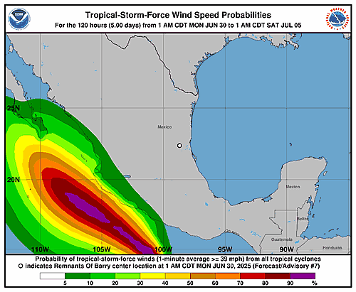
651
WTNT42 KNHC 300233
TCDAT2

Tropical Depression Barry Discussion Number   6
NWS National Hurricane Center Miami FL       AL022025
1000 PM CDT Sun Jun 29 2025

Satellite and radar imagery show that Barry became less defined
over the past several hours, and this has made the center
difficult to locate.  It is estimated that the system made
landfall an hour or two ago, to the south of Tampico Mexico.  Deep
convection associated with the cyclone has diminished since earlier
today.  Strong westerly shear has apparently caused the system to
weaken to a depression by the time it reached the coast.  The
current intensity estimate is set to 30 kt, which is in agreement
with a Dvorak T-number from TAFB.

Barry's initial motion estimate is still northwestward, or 320/8
kt, while being steered by the flow to the west of a high pressure
system over the central Gulf. This general motion is likely to
continue for the next 12-24 hours, taking the system farther
inland.  Barry should dissipate over the mountainous terrain of
Mexico on Monday.

The primary impact with Barry remains heavy rainfall and flash
flooding for the upslope areas of eastern Mexico. Please see the
latest forecast rainfall graphic from the Weather Prediction Center
International Desk for more information.

Key Message:

1. Barry or its remnants will produce heavy rainfall across
portions of northeastern Mexico through Monday. Life-threatening
flooding and mudslides are possible, particularly in areas of steep
terrain.


FORECAST POSITIONS AND MAX WINDS

INIT  30/0300Z 22.0N  97.8W   30 KT  35 MPH...INLAND
 12H  30/1200Z 22.7N  98.5W   25 KT  30 MPH...INLAND
 24H  01/0000Z...DISSIPATED

$$
Forecaster Pasch
5-Day Uncertainty Track last updated Mon, 30 Jun 2025 02:34:39 GMT
Wind Speed Probabilities last updated Mon, 30 Jun 2025 02:34:39 GMT
Issued at 0300 UTC MON JUN 30 2025
299
FONT12 KNHC 300232
PWSAT2

TROPICAL DEPRESSION BARRY WIND SPEED PROBABILITIES NUMBER   6
NWS NATIONAL HURRICANE CENTER MIAMI FL       AL022025
0300 UTC MON JUN 30 2025

AT 0300Z THE CENTER OF TROPICAL DEPRESSION BARRY WAS LOCATED NEAR
LATITUDE 22.0 NORTH...LONGITUDE 97.8 WEST WITH MAXIMUM SUSTAINED
WINDS NEAR 30 KTS...35 MPH...55 KM/H.

Z INDICATES COORDINATED UNIVERSAL TIME (GREENWICH)
   ATLANTIC STANDARD TIME (AST)...SUBTRACT 4 HOURS FROM Z TIME
   EASTERN  DAYLIGHT TIME (EDT)...SUBTRACT 4 HOURS FROM Z TIME
   CENTRAL  DAYLIGHT TIME (CDT)...SUBTRACT 5 HOURS FROM Z TIME

WIND SPEED PROBABILITY TABLE FOR SPECIFIC LOCATIONS

CHANCES OF SUSTAINED (1-MINUTE AVERAGE) WIND SPEEDS OF AT LEAST
   ...34 KT (39 MPH... 63 KM/H)...
   ...50 KT (58 MPH... 93 KM/H)...
   ...64 KT (74 MPH...119 KM/H)...
FOR LOCATIONS AND TIME PERIODS DURING THE NEXT 5 DAYS

PROBABILITIES FOR LOCATIONS ARE GIVEN AS OP(CP) WHERE
    OP  IS THE PROBABILITY OF THE EVENT BEGINNING DURING
        AN INDIVIDUAL TIME PERIOD (ONSET PROBABILITY)
   (CP) IS THE PROBABILITY OF THE EVENT OCCURRING BETWEEN
        00Z MON AND THE FORECAST HOUR (CUMULATIVE PROBABILITY)

PROBABILITIES ARE GIVEN IN PERCENT
X INDICATES PROBABILITIES LESS THAN 1 PERCENT
PROBABILITIES FOR 34 KT AND 50 KT ARE SHOWN AT A GIVEN LOCATION WHEN
THE 5-DAY CUMULATIVE PROBABILITY IS AT LEAST 3 PERCENT.
PROBABILITIES FOR 34...50...64 KT SHOWN WHEN THE 5-DAY
64-KT CUMULATIVE PROBABILITY IS AT LEAST 1 PERCENT.


  - - - - WIND SPEED PROBABILITIES FOR SELECTED LOCATIONS - - - -

               FROM    FROM    FROM    FROM    FROM    FROM    FROM
  TIME       00Z MON 12Z MON 00Z TUE 12Z TUE 00Z WED 00Z THU 00Z FRI
PERIODS         TO      TO      TO      TO      TO      TO      TO
             12Z MON 00Z TUE 12Z TUE 00Z WED 00Z THU 00Z FRI 00Z SAT

FORECAST HOUR    (12)   (24)    (36)    (48)    (72)    (96)   (120)
- - - - - - - - - - - - - - - - - - - - - - - - - - - - - - - - - -
LOCATION       KT

TAMPICO MX     34  8   X( 8)   X( 8)   X( 8)   X( 8)   X( 8)   X( 8)

$$
FORECASTER PASCH
5-Day Uncertainty Track last updated Sun, 29 Jun 2025 23:58:51 GMT
Wind Speed Probabilities last updated Sun, 29 Jun 2025 21:21:47 GMT
5-Day Uncertainty Track last updated Sun, 29 Jun 2025 20:37:56 GMT
Wind Speed Probabilities last updated Sun, 29 Jun 2025 21:21:47 GMT
5-Day Uncertainty Track last updated Sun, 29 Jun 2025 20:37:56 GMT
Wind Speed Probabilities last updated Sun, 29 Jun 2025 21:21:49 GMT
Issued at 2100 UTC SUN JUN 29 2025
000
FONT12 KNHC 292036
PWSAT2

TROPICAL STORM BARRY WIND SPEED PROBABILITIES NUMBER   5
NWS NATIONAL HURRICANE CENTER MIAMI FL       AL022025
2100 UTC SUN JUN 29 2025

AT 2100Z THE CENTER OF TROPICAL STORM BARRY WAS LOCATED NEAR
LATITUDE 21.2 NORTH...LONGITUDE 96.9 WEST WITH MAXIMUM SUSTAINED
WINDS NEAR 40 KTS...45 MPH...75 KM/H.

Z INDICATES COORDINATED UNIVERSAL TIME (GREENWICH)
   ATLANTIC STANDARD TIME (AST)...SUBTRACT 4 HOURS FROM Z TIME
   EASTERN  DAYLIGHT TIME (EDT)...SUBTRACT 4 HOURS FROM Z TIME
   CENTRAL  DAYLIGHT TIME (CDT)...SUBTRACT 5 HOURS FROM Z TIME

WIND SPEED PROBABILITY TABLE FOR SPECIFIC LOCATIONS

CHANCES OF SUSTAINED (1-MINUTE AVERAGE) WIND SPEEDS OF AT LEAST
   ...34 KT (39 MPH... 63 KM/H)...
   ...50 KT (58 MPH... 93 KM/H)...
   ...64 KT (74 MPH...119 KM/H)...
FOR LOCATIONS AND TIME PERIODS DURING THE NEXT 5 DAYS

PROBABILITIES FOR LOCATIONS ARE GIVEN AS OP(CP) WHERE
    OP  IS THE PROBABILITY OF THE EVENT BEGINNING DURING
        AN INDIVIDUAL TIME PERIOD (ONSET PROBABILITY)
   (CP) IS THE PROBABILITY OF THE EVENT OCCURRING BETWEEN
        18Z SUN AND THE FORECAST HOUR (CUMULATIVE PROBABILITY)

PROBABILITIES ARE GIVEN IN PERCENT
X INDICATES PROBABILITIES LESS THAN 1 PERCENT
PROBABILITIES FOR 34 KT AND 50 KT ARE SHOWN AT A GIVEN LOCATION WHEN
THE 5-DAY CUMULATIVE PROBABILITY IS AT LEAST 3 PERCENT.
PROBABILITIES FOR 34...50...64 KT SHOWN WHEN THE 5-DAY
64-KT CUMULATIVE PROBABILITY IS AT LEAST 1 PERCENT.


  - - - - WIND SPEED PROBABILITIES FOR SELECTED LOCATIONS - - - -

               FROM    FROM    FROM    FROM    FROM    FROM    FROM
  TIME       18Z SUN 06Z MON 18Z MON 06Z TUE 18Z TUE 18Z WED 18Z THU
PERIODS         TO      TO      TO      TO      TO      TO      TO
             06Z MON 18Z MON 06Z TUE 18Z TUE 18Z WED 18Z THU 18Z FRI

FORECAST HOUR    (12)   (24)    (36)    (48)    (72)    (96)   (120)
- - - - - - - - - - - - - - - - - - - - - - - - - - - - - - - - - -
LOCATION       KT

TAMPICO MX     34  6   1( 7)   X( 7)   X( 7)   X( 7)   X( 7)   X( 7)

$$
FORECASTER PAPIN
5-Day Uncertainty Track last updated Sun, 29 Jun 2025 20:37:56 GMT
Wind Speed Probabilities last updated Sun, 29 Jun 2025 20:37:56 GMT
5-Day Uncertainty Track last updated Sun, 29 Jun 2025 17:38:30 GMT
Wind Speed Probabilities last updated Sun, 29 Jun 2025 15:21:26 GMT
5-Day Uncertainty Track last updated Sun, 29 Jun 2025 17:38:30 GMT
Wind Speed Probabilities last updated Sun, 29 Jun 2025 15:21:26 GMT
5-Day Uncertainty Track last updated Sun, 29 Jun 2025 14:56:50 GMT
Wind Speed Probabilities last updated Sun, 29 Jun 2025 15:21:26 GMT
5-Day Uncertainty Track last updated Sun, 29 Jun 2025 14:56:50 GMT
Wind Speed Probabilities last updated Sun, 29 Jun 2025 15:21:26 GMT
Issued at 1000 AM CDT Sun Jun 29 2025
000
WTNT42 KNHC 291507
TCDAT2

Tropical Storm Barry Discussion Number   4
NWS National Hurricane Center Miami FL       AL022025
1000 AM CDT Sun Jun 29 2025

Convective activity with the system has increased somewhat this
morning, though it is not terribly well-organized, thanks in large
part to continued 25-30 kt westerly vertical wind shear over the
system. Air Force Reserve Reconnaissance is currently sampling the
system, and has found a better defined center this morning with
fixes also indicating that the system is gaining more latitude.
Within the past 20 minutes, a northeast inbound leg into the storm
found 850 mb flight level winds of 43 kt, and a dropsonde with a
surface wind gust of 39 kt. This recent wind information is the
primary basis for increasing the winds to 35 kt, making the
depression Tropical Storm Barry.

Aircraft fixes indicate the storm is now moving northwestward,
with the motion estimated at 310/5 kt. A narrow low-to-mid level
ridge over the central Gulf should continue to steer the tropical
cyclone in this direction until it makes landfall over eastern
Mexico by the end of today or tonight. The latest NHC track forecast
is just a bit more northwestward compared to the prior one,
mostly accounting for changes in the initial position, but remain
in good agreement with the track guidance consensus. As mentioned
previously, the strongest winds are expected to occur north of the
center along the coast within the tropical storm warning area this
afternoon and tonight.

An upper-level trough located over southern Texas appears partially
responsible for the unfavorable upper-level winds currently over the
tropical storm. This is unlikely to change today, and in fact might
even get worse as upper-level outflow from newly formed Tropical
Storm Flossie in the eastern Pacific becomes more pronounced.
Despite the shear, waters over the Gulf remain warm (28-29 C) and
there is plenty of deep-layer moisture. The upper-level flow pattern
is also quite difluent over the system, so the latest NHC intensity
forecast shows a little more intensification before landfall tonight
over eastern Mexico. This is more or less in line with the regional
hurricane model guidance (e.g., HWRF and HAFS-B). The system should
then weaken quickly as soon as it moves inland overnight with
complete dissipation over the rugged terrain of central Mexico by
the end of the day Monday.

The primary impacts with Barry remain heavy rainfall and flash
flooding for portions of eastern Mexico in upslope terrain as the
system moves inland over the area of over the next day or two.

Key Messages:

1. Tropical Storm Barry will produce heavy rainfall across portions
of northeastern Mexico.  Life-threatening flooding and mudslides,
especially in areas of steep terrain, are possible.

2. Tropical storm conditions, especially in gusts, are expected
later today and tonight over portions of eastern Mexico in the
tropical storm warning area.


FORECAST POSITIONS AND MAX WINDS

INIT  29/1500Z 20.4N  96.2W   35 KT  40 MPH
 12H  30/0000Z 21.2N  97.2W   40 KT  45 MPH
 24H  30/1200Z 22.0N  98.2W   30 KT  35 MPH...INLAND
 36H  01/0000Z...DISSIPATED

$$
Forecaster Papin
5-Day Uncertainty Track last updated Sun, 29 Jun 2025 14:56:50 GMT
Wind Speed Probabilities last updated Sun, 29 Jun 2025 14:56:50 GMT
5-Day Uncertainty Track last updated Sun, 29 Jun 2025 14:56:50 GMT
Wind Speed Probabilities last updated Sun, 29 Jun 2025 14:56:50 GMT
Issued at 1500 UTC SUN JUN 29 2025
153
FONT12 KNHC 291455
PWSAT2

TROPICAL STORM BARRY WIND SPEED PROBABILITIES NUMBER   4
NWS NATIONAL HURRICANE CENTER MIAMI FL       AL022025
1500 UTC SUN JUN 29 2025

AT 1500Z THE CENTER OF TROPICAL STORM BARRY WAS LOCATED NEAR
LATITUDE 20.4 NORTH...LONGITUDE 96.2 WEST WITH MAXIMUM SUSTAINED
WINDS NEAR 35 KTS...40 MPH...65 KM/H.

Z INDICATES COORDINATED UNIVERSAL TIME (GREENWICH)
   ATLANTIC STANDARD TIME (AST)...SUBTRACT 4 HOURS FROM Z TIME
   EASTERN  DAYLIGHT TIME (EDT)...SUBTRACT 4 HOURS FROM Z TIME
   CENTRAL  DAYLIGHT TIME (CDT)...SUBTRACT 5 HOURS FROM Z TIME

WIND SPEED PROBABILITY TABLE FOR SPECIFIC LOCATIONS

CHANCES OF SUSTAINED (1-MINUTE AVERAGE) WIND SPEEDS OF AT LEAST
   ...34 KT (39 MPH... 63 KM/H)...
   ...50 KT (58 MPH... 93 KM/H)...
   ...64 KT (74 MPH...119 KM/H)...
FOR LOCATIONS AND TIME PERIODS DURING THE NEXT 5 DAYS

PROBABILITIES FOR LOCATIONS ARE GIVEN AS OP(CP) WHERE
    OP  IS THE PROBABILITY OF THE EVENT BEGINNING DURING
        AN INDIVIDUAL TIME PERIOD (ONSET PROBABILITY)
   (CP) IS THE PROBABILITY OF THE EVENT OCCURRING BETWEEN
        12Z SUN AND THE FORECAST HOUR (CUMULATIVE PROBABILITY)

PROBABILITIES ARE GIVEN IN PERCENT
X INDICATES PROBABILITIES LESS THAN 1 PERCENT
PROBABILITIES FOR 34 KT AND 50 KT ARE SHOWN AT A GIVEN LOCATION WHEN
THE 5-DAY CUMULATIVE PROBABILITY IS AT LEAST 3 PERCENT.
PROBABILITIES FOR 34...50...64 KT SHOWN WHEN THE 5-DAY
64-KT CUMULATIVE PROBABILITY IS AT LEAST 1 PERCENT.


  - - - - WIND SPEED PROBABILITIES FOR SELECTED LOCATIONS - - - -

               FROM    FROM    FROM    FROM    FROM    FROM    FROM
  TIME       12Z SUN 00Z MON 12Z MON 00Z TUE 12Z TUE 12Z WED 12Z THU
PERIODS         TO      TO      TO      TO      TO      TO      TO
             00Z MON 12Z MON 00Z TUE 12Z TUE 12Z WED 12Z THU 12Z FRI

FORECAST HOUR    (12)   (24)    (36)    (48)    (72)    (96)   (120)
- - - - - - - - - - - - - - - - - - - - - - - - - - - - - - - - - -
LOCATION       KT

TAMPICO MX     34  1   6( 7)   X( 7)   X( 7)   X( 7)   X( 7)   X( 7)

TUXPAN MX      34  4   2( 6)   X( 6)   X( 6)   X( 6)   X( 6)   X( 6)

$$
FORECASTER PAPIN
5-Day Uncertainty Track last updated Sun, 29 Jun 2025 11:52:42 GMT
Wind Speed Probabilities last updated Sun, 29 Jun 2025 09:21:19 GMT
5-Day Uncertainty Track last updated Sun, 29 Jun 2025 11:52:42 GMT
Wind Speed Probabilities last updated Sun, 29 Jun 2025 09:21:19 GMT
5-Day Uncertainty Track last updated Sun, 29 Jun 2025 08:34:35 GMT
Wind Speed Probabilities last updated Sun, 29 Jun 2025 09:21:19 GMT
5-Day Uncertainty Track last updated Sun, 29 Jun 2025 08:34:35 GMT
Wind Speed Probabilities last updated Sun, 29 Jun 2025 08:34:35 GMT
Issued at 0900 UTC SUN JUN 29 2025
452
FONT12 KNHC 290833
PWSAT2

TROPICAL DEPRESSION TWO WIND SPEED PROBABILITIES NUMBER   3
NWS NATIONAL HURRICANE CENTER MIAMI FL       AL022025
0900 UTC SUN JUN 29 2025

AT 0900Z THE CENTER OF TROPICAL DEPRESSION TWO WAS LOCATED NEAR
LATITUDE 19.9 NORTH...LONGITUDE 95.9 WEST WITH MAXIMUM SUSTAINED
WINDS NEAR 30 KTS...35 MPH...55 KM/H.

Z INDICATES COORDINATED UNIVERSAL TIME (GREENWICH)
   ATLANTIC STANDARD TIME (AST)...SUBTRACT 4 HOURS FROM Z TIME
   EASTERN  DAYLIGHT TIME (EDT)...SUBTRACT 4 HOURS FROM Z TIME
   CENTRAL  DAYLIGHT TIME (CDT)...SUBTRACT 5 HOURS FROM Z TIME

WIND SPEED PROBABILITY TABLE FOR SPECIFIC LOCATIONS

CHANCES OF SUSTAINED (1-MINUTE AVERAGE) WIND SPEEDS OF AT LEAST
   ...34 KT (39 MPH... 63 KM/H)...
   ...50 KT (58 MPH... 93 KM/H)...
   ...64 KT (74 MPH...119 KM/H)...
FOR LOCATIONS AND TIME PERIODS DURING THE NEXT 5 DAYS

PROBABILITIES FOR LOCATIONS ARE GIVEN AS OP(CP) WHERE
    OP  IS THE PROBABILITY OF THE EVENT BEGINNING DURING
        AN INDIVIDUAL TIME PERIOD (ONSET PROBABILITY)
   (CP) IS THE PROBABILITY OF THE EVENT OCCURRING BETWEEN
        06Z SUN AND THE FORECAST HOUR (CUMULATIVE PROBABILITY)

PROBABILITIES ARE GIVEN IN PERCENT
X INDICATES PROBABILITIES LESS THAN 1 PERCENT
PROBABILITIES FOR 34 KT AND 50 KT ARE SHOWN AT A GIVEN LOCATION WHEN
THE 5-DAY CUMULATIVE PROBABILITY IS AT LEAST 3 PERCENT.
PROBABILITIES FOR 34...50...64 KT SHOWN WHEN THE 5-DAY
64-KT CUMULATIVE PROBABILITY IS AT LEAST 1 PERCENT.


  - - - - WIND SPEED PROBABILITIES FOR SELECTED LOCATIONS - - - -

               FROM    FROM    FROM    FROM    FROM    FROM    FROM
  TIME       06Z SUN 18Z SUN 06Z MON 18Z MON 06Z TUE 06Z WED 06Z THU
PERIODS         TO      TO      TO      TO      TO      TO      TO
             18Z SUN 06Z MON 18Z MON 06Z TUE 06Z WED 06Z THU 06Z FRI

FORECAST HOUR    (12)   (24)    (36)    (48)    (72)    (96)   (120)
- - - - - - - - - - - - - - - - - - - - - - - - - - - - - - - - - -
LOCATION       KT

TAMPICO MX     34  X   3( 3)   X( 3)   X( 3)   X( 3)   X( 3)   X( 3)

TUXPAN MX      34  1   3( 4)   X( 4)   X( 4)   X( 4)   X( 4)   X( 4)

$$
FORECASTER CANGIALOSI