Issued at 600 PM CST Sun Jun 29 2025
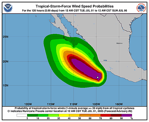
000
WTPZ31 KNHC 292342
TCPEP1

BULLETIN
Tropical Storm Flossie Intermediate Advisory Number 3A
NWS National Hurricane Center Miami FL       EP062025
600 PM CST Sun Jun 29 2025

...FLOSSIE EXPECTED TO BRING AREAS OF HEAVY RAINS ALONG THE COAST
OF SOUTHWESTERN MEXICO...


SUMMARY OF 600 PM CST...0000 UTC...INFORMATION
----------------------------------------------
LOCATION...13.7N 100.7W
ABOUT 225 MI...360 KM SSW OF ACAPULCO MEXICO
ABOUT 435 MI...700 KM SE OF MANZANILLO MEXICO
MAXIMUM SUSTAINED WINDS...40 MPH...65 KM/H
PRESENT MOVEMENT...WNW OR 295 DEGREES AT 8 MPH...13 KM/H
MINIMUM CENTRAL PRESSURE...1005 MB...29.68 INCHES


WATCHES AND WARNINGS
--------------------
CHANGES WITH THIS ADVISORY:

None.

SUMMARY OF WATCHES AND WARNINGS IN EFFECT:

A Tropical Storm Watch is in effect for...
* Southwest coast of Mexico from Zihuatanejo to Cabo Corrientes

A Tropical Storm Watch means that tropical storm conditions are
possible within the watch area, generally within 48 hours.

Interests elsewhere in southwestern Mexico should monitor the
progress of Tropical Storm Flossie.

For storm information specific to your area, please monitor
products issued by your national meteorological service.


DISCUSSION AND OUTLOOK
----------------------
At 600 PM CST (0000 UTC), the center of Tropical Storm Flossie was
located near latitude 13.7 North, longitude 100.7 West. Flossie is
moving toward the west-northwest near 8 mph (13 km/h). A
west-northwest to northwestward motion should continue over the next
few days.

Maximum sustained winds are near 40 mph (65 km/h) with higher
gusts. Steady strengthening is forecast during the next few days,
and the system is expected to become a hurricane late Monday or
Tuesday.

Tropical-storm-force winds extend outward up to 105 miles (165 km)
from the center.

The estimated minimum central pressure is 1005 mb (29.68 inches).


HAZARDS AFFECTING LAND
----------------------
Key messages for Tropical Storm Flossie can be found in the Tropical
Cyclone Discussion under AWIPS header MIATCDEP1 and WMO header
WTPZ41 KNHC.

RAINFALL: Tropical Storm Flossie is expected to produce rainfall
totals of 3 to 6 inches, with isolated maximum totals of 10 inches,
across portions of the Mexican states of Oaxaca, Guerrero,
Michoacán, Colima, and Jalisco through early this week. This
rainfall may lead to areas of life-threatening flooding and
mudslides, especially in areas of steep terrain.

For a complete depiction of forecast rainfall associated with
Tropical Storm Flossie, please see the National Weather Service
Storm Total Rainfall Graphic available at
hurricanes.gov/graphics_ep1.shtml?rainqpf

WIND: Tropical storm conditions are possible along the coast within
the watch area late Monday and Tuesday.

SURF: Swells generated by Flossie will affect portions of the coast
of southwestern Mexico during the next few days. These swells are
likely to cause life-threatening surf and rip current conditions.
Please consult products from your local weather office.


NEXT ADVISORY
-------------
Next complete advisory at 900 PM CST.

$$
Forecaster Bucci