Issued at 1000 PM EST Wed Nov 06 2024
572
WTNT33 KNHC 070251
TCPAT3

BULLETIN
Hurricane Rafael Advisory Number  14
NWS National Hurricane Center Miami FL       AL182024
1000 PM EST Wed Nov 06 2024

...CENTER OF RAFAEL MOVING AWAY FROM WESTERN CUBA...
...STORM SURGE, WINDS, AND RAINS SHOULD SUBSIDE ACROSS CUBA
TONIGHT...


SUMMARY OF 1000 PM EST...0300 UTC...INFORMATION
-----------------------------------------------
LOCATION...23.5N 83.6W
ABOUT 80 MI...125 KM WNW OF HAVANA CUBA
ABOUT 135 MI...220 KM WSW OF KEY WEST FLORIDA
MAXIMUM SUSTAINED WINDS...105 MPH...165 KM/H
PRESENT MOVEMENT...NW OR 315 DEGREES AT 13 MPH...20 KM/H
MINIMUM CENTRAL PRESSURE...969 MB...28.62 INCHES


WATCHES AND WARNINGS
--------------------
CHANGES WITH THIS ADVISORY:

The Government of Cuba has discontinued all warnings for the
provinces of Villa Clara, Cienfuegos, Matanzas, and the Isle of
Youth.

SUMMARY OF WATCHES AND WARNINGS IN EFFECT:

A Hurricane Warning is in effect for...
* Cuban provinces of Pinar del Rio, Artemisa, La Habana, and
Mayabeque

A Tropical Storm Warning is in effect for...
* Lower and Middle Florida Keys from Key West to west of the
Channel 5 Bridge
* Dry Tortugas

A Hurricane Warning means that hurricane conditions are expected
somewhere within the warning area.

A Tropical Storm Warning means that tropical storm conditions are
expected somewhere within the warning area.

For storm information specific to your area in the United
States, including possible inland watches and warnings, please
monitor products issued by your local National Weather Service
forecast office. For storm information specific to your area
outside of the United States, please monitor products issued by
your national meteorological service.


DISCUSSION AND OUTLOOK
----------------------
At 1000 PM EST (0300 UTC), the center of Hurricane Rafael was
located near latitude 23.5 North, longitude 83.6 West. Rafael is
moving toward the northwest near 13 mph (20 km/h).  A general
northwestward motion is anticipated tonight. A turn toward the west
at a slower forward speed is expected on Thursday, with this general
motion continuing through Saturday.  On the forecast track, Rafael
is expected to move away from western Cuba over the southeastern
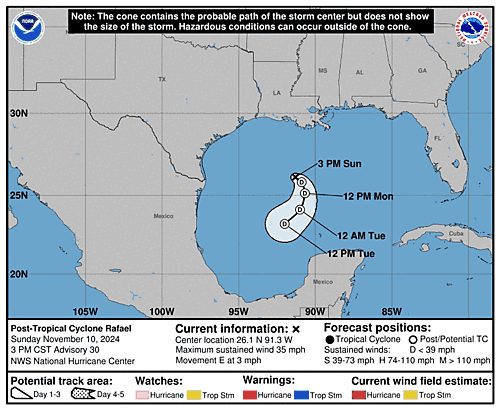
Gulf of Mexico tonight. Rafael is then forecast to move over the
southern Gulf of Mexico for the next few days.

Reports from Air Force Reserve and NOAA Hurricane Hunter aircraft
indicate that maximum sustained winds are near 105 mph (165 km/h)
with higher gusts.  Some weakening is possible tonight and Thursday,
with little change in strength expected on Friday.

Hurricane-force winds extend outward up to 30 miles (45 km) from the
center and tropical-storm-force winds extend outward up to 115 miles
(185 km).

The minimum central pressure estimated from the Hurricane Hunter
aircraft data is 969 mb (28.62 inches).


HAZARDS AFFECTING LAND
----------------------
Key messages for Hurricane Rafael can be found in the Tropical
Cyclone Discussion under AWIPS header MIATCDAT3 and WMO header
WTNT43 KNHC and on the web at hurricanes.gov/text/MIATCDAT3.shtml

WIND:  Hurricane conditions are expected to continue in portions of
western Cuba for the next few hours.  Tropical storm conditions
are expected in parts of the lower and middle Florida Keys through
tonight.

RAINFALL: Additional rainfall amounts of 2 to 4 inches are expected
into Thursday, leading to storm total accumulations of 12 inches
across portions of western Cuba.  This may lead to areas of flash
flooding and mudslides, especially along the higher terrain.

Rainfall totals of 1 to 3 inches are expected for the Lower and
Middle Florida Keys.

For a complete depiction of forecast rainfall associated with
Hurricane Rafael, please see the National Weather Service Storm
Total Rainfall Graphic, available at
https://www.nhc.noaa.gov/graphics_at3.shtml?rainqpf

STORM SURGE: Storm surge flooding along the coast of Cuba should
subside tonight.

The combination of a storm surge and the tide will cause normally
dry areas near the coast to be flooded by rising waters moving
inland from the shoreline.  The water could reach the following
heights above ground somewhere in the indicated areas if the peak
surge occurs at the time of high tide...

Dry Tortugas...1-3 ft
Lower Florida Keys...1-2 ft

TORNADOES: A couple of brief tornadoes remain possible this evening,
mainly over parts of the Lower Florida Keys.

SURF: Swells generated by Rafael are expected to affect much of the
northwestern Caribbean during the next day or so and will also
spread across most of the Gulf of Mexico from east to west late this
week into the weekend. These swells are likely to cause
life-threatening surf and rip current conditions. Please consult
products from your local weather office.


NEXT ADVISORY
-------------
Next intermediate advisory at 100 AM EST.
Next complete advisory at 400 AM EST.

$$
Forecaster Beven


