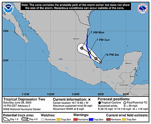
5-Day Uncertainty Track last updated Fri, 15 Nov 2024 11:59:38 GMT
Wind Speed Probabilities last updated Fri, 15 Nov 2024 09:22:52 GMT
NHC Hurricane Advisories
, UTC by nhcauto
, UTC by nhcauto
, UTC by nhcauto
Issued at 0900 UTC FRI NOV 15 2024
000 FONT14 KNHC 150844 PWSAT4 TROPICAL STORM SARA WIND SPEED PROBABILITIES NUMBER 7 NWS NATIONAL HURRICANE CENTER MIAMI FL AL192024 0900 UTC FRI NOV 15 2024 AT 0900Z THE CENTER OF TROPICAL STORM SARA WAS LOCATED NEAR LATITUDE 16.0 NORTH...LONGITUDE 85.1 WEST WITH MAXIMUM SUSTAINED WINDS NEAR 40 KTS...45 MPH...75 KM/H. Z INDICATES COORDINATED UNIVERSAL TIME (GREENWICH) ATLANTIC STANDARD TIME (AST)...SUBTRACT 4 HOURS FROM Z TIME EASTERN STANDARD TIME (EST)...SUBTRACT 5 HOURS FROM Z TIME CENTRAL STANDARD TIME (CST)...SUBTRACT 6 HOURS FROM Z TIME WIND SPEED PROBABILITY TABLE FOR SPECIFIC LOCATIONS CHANCES OF SUSTAINED (1-MINUTE AVERAGE) WIND SPEEDS OF AT LEAST ...34 KT (39 MPH... 63 KM/H)... ...50 KT (58 MPH... 93 KM/H)... ...64 KT (74 MPH...119 KM/H)... FOR LOCATIONS AND TIME PERIODS DURING THE NEXT 5 DAYS PROBABILITIES FOR LOCATIONS ARE GIVEN AS OP(CP) WHERE OP IS THE PROBABILITY OF THE EVENT BEGINNING DURING AN INDIVIDUAL TIME PERIOD (ONSET PROBABILITY) (CP) IS THE PROBABILITY OF THE EVENT OCCURRING BETWEEN 06Z FRI AND THE FORECAST HOUR (CUMULATIVE PROBABILITY) PROBABILITIES ARE GIVEN IN PERCENT X INDICATES PROBABILITIES LESS THAN 1 PERCENT PROBABILITIES FOR 34 KT AND 50 KT ARE SHOWN AT A GIVEN LOCATION WHEN THE 5-DAY CUMULATIVE PROBABILITY IS AT LEAST 3 PERCENT. PROBABILITIES FOR 34...50...64 KT SHOWN WHEN THE 5-DAY 64-KT CUMULATIVE PROBABILITY IS AT LEAST 1 PERCENT. - - - - WIND SPEED PROBABILITIES FOR SELECTED LOCATIONS - - - - FROM FROM FROM FROM FROM FROM FROM TIME 06Z FRI 18Z FRI 06Z SAT 18Z SAT 06Z SUN 06Z MON 06Z TUE PERIODS TO TO TO TO TO TO TO 18Z FRI 06Z SAT 18Z SAT 06Z SUN 06Z MON 06Z TUE 06Z WED FORECAST HOUR (12) (24) (36) (48) (72) (96) (120) - - - - - - - - - - - - - - - - - - - - - - - - - - - - - - - - - - LOCATION KT COZUMEL MX 34 X 1( 1) X( 1) 1( 2) 1( 3) X( 3) X( 3) BELIZE CITY 34 1 4( 5) 8(13) 13(26) 9(35) X(35) X(35) BELIZE CITY 50 X X( X) 1( 1) 1( 2) 2( 4) X( 4) X( 4) PUERTO BARRIOS 34 X 2( 2) 3( 5) 4( 9) 5(14) X(14) X(14) GUANAJA 34 92 X(92) 1(93) X(93) X(93) X(93) X(93) GUANAJA 50 2 2( 4) 1( 5) 1( 6) X( 6) X( 6) X( 6) $$ FORECASTER HAGEN
, UTC by nhcauto
, UTC by nhcauto
Issued at 1000 PM EST Thu Nov 14 2024
404 WTNT44 KNHC 150255 TCDAT4 Tropical Storm Sara Discussion Number 6 NWS National Hurricane Center Miami FL AL192024 1000 PM EST Thu Nov 14 2024 Radar data from Belize shows heavy rainfall from Sara continues to spread over portions of Belize, the Yucatan Peninsula of Mexico, and Honduras tonight. There has been some increase in deep convection closer to the center of the storm this evening. A recent Air Force Hurricane Hunter flight leg over the northern semicircle found 925-mb flight-level winds up to 52 kt, which supports an initial intensity of 40 kt. The flight-level wind data also indicated that the center of Sara is likely just inland or very near the northeastern coast of Honduras, and the center was somewhat elongated west to east. Sara is moving westward (270/9 kt) to the south of a mid-level ridge centered over the Gulf of Mexico. A slower westward motion is expected over the next couple of days, with the center of Sara forecast to move along or very near the coast of northern Honduras. As the ridge slides eastward later this weekend, Sarah should turn toward the west-northwest by late Saturday and move across the Gulf of Honduras before approaching the coast of Belize on Sunday. The updated NHC track prediction is nudged slightly south in the short term, but generally lies between the latest simple and corrected consensus aids (TVCA/HCCA) with little overall change from the previous forecast. While the environmental and oceanic conditions are favorable for some intensification, Sara's relatively broad structure and proximity to land are likely to inhibit significant strengthening. Given the slight southward track adjustment, little intensity change is expected in the short term while the storm continues to interact with land along the northeastern coast of Honduras. Some further strengthening is forecast thereafter once Sara turns west-northwestward and moves over water. The updated NHC forecast shows a similar peak intensity as the previous prediction, in best agreement with the intensity consensus aids. Once again, a more northern track than forecast could result in additional strengthening. The storm is forecast to move inland over Belize on Sunday and quickly weaken while moving over the Yucatan Peninsula. This forecast shows dissipation by day 4, as the global models agree that the low-level circulation of Sara is unlikely to survive its trek across the Yucatan Peninsula. KEY MESSAGES: 1. Through early next week, heavy rainfall from Sara will cause potentially catastrophic flash flooding and mudslides over northern portions of Honduras. 2. Elsewhere across Belize, El Salvador, eastern Guatemala, western Nicaragua, and the Mexican State of Quintana Roo, heavy rainfall will cause significant and life-threatening flash flooding and mudslides. 3. Tropical storm conditions are expected along portions of the northern coast of Honduras, and the adjacent Bay Islands where tropical storm warnings are in effect. 4. The system is forecast to approach Belize and the Yucatan Peninsula of Mexico late this weekend where there is a risk of strong winds. Residents in these areas should monitor the latest forecast updates. FORECAST POSITIONS AND MAX WINDS INIT 15/0300Z 15.8N 84.5W 40 KT 45 MPH...NEAR THE COAST 12H 15/1200Z 15.9N 85.3W 40 KT 45 MPH...NEAR THE COAST 24H 16/0000Z 16.0N 86.0W 40 KT 45 MPH...NEAR THE COAST 36H 16/1200Z 16.1N 86.4W 45 KT 50 MPH 48H 17/0000Z 16.3N 87.0W 45 KT 50 MPH 60H 17/1200Z 16.6N 87.9W 45 KT 50 MPH 72H 18/0000Z 17.4N 89.2W 30 KT 35 MPH...INLAND 96H 19/0000Z...DISSIPATED $$ Forecaster Reinhart
, UTC by nhcauto
Issued at 0300 UTC FRI NOV 15 2024
939 FONT14 KNHC 150253 PWSAT4 TROPICAL STORM SARA WIND SPEED PROBABILITIES NUMBER 6 NWS NATIONAL HURRICANE CENTER MIAMI FL AL192024 0300 UTC FRI NOV 15 2024 AT 0300Z THE CENTER OF TROPICAL STORM SARA WAS LOCATED NEAR LATITUDE 15.8 NORTH...LONGITUDE 84.5 WEST WITH MAXIMUM SUSTAINED WINDS NEAR 40 KTS...45 MPH...75 KM/H. Z INDICATES COORDINATED UNIVERSAL TIME (GREENWICH) ATLANTIC STANDARD TIME (AST)...SUBTRACT 4 HOURS FROM Z TIME EASTERN STANDARD TIME (EST)...SUBTRACT 5 HOURS FROM Z TIME CENTRAL STANDARD TIME (CST)...SUBTRACT 6 HOURS FROM Z TIME WIND SPEED PROBABILITY TABLE FOR SPECIFIC LOCATIONS CHANCES OF SUSTAINED (1-MINUTE AVERAGE) WIND SPEEDS OF AT LEAST ...34 KT (39 MPH... 63 KM/H)... ...50 KT (58 MPH... 93 KM/H)... ...64 KT (74 MPH...119 KM/H)... FOR LOCATIONS AND TIME PERIODS DURING THE NEXT 5 DAYS PROBABILITIES FOR LOCATIONS ARE GIVEN AS OP(CP) WHERE OP IS THE PROBABILITY OF THE EVENT BEGINNING DURING AN INDIVIDUAL TIME PERIOD (ONSET PROBABILITY) (CP) IS THE PROBABILITY OF THE EVENT OCCURRING BETWEEN 00Z FRI AND THE FORECAST HOUR (CUMULATIVE PROBABILITY) PROBABILITIES ARE GIVEN IN PERCENT X INDICATES PROBABILITIES LESS THAN 1 PERCENT PROBABILITIES FOR 34 KT AND 50 KT ARE SHOWN AT A GIVEN LOCATION WHEN THE 5-DAY CUMULATIVE PROBABILITY IS AT LEAST 3 PERCENT. PROBABILITIES FOR 34...50...64 KT SHOWN WHEN THE 5-DAY 64-KT CUMULATIVE PROBABILITY IS AT LEAST 1 PERCENT. - - - - WIND SPEED PROBABILITIES FOR SELECTED LOCATIONS - - - - FROM FROM FROM FROM FROM FROM FROM TIME 00Z FRI 12Z FRI 00Z SAT 12Z SAT 00Z SUN 00Z MON 00Z TUE PERIODS TO TO TO TO TO TO TO 12Z FRI 00Z SAT 12Z SAT 00Z SUN 00Z MON 00Z TUE 00Z WED FORECAST HOUR (12) (24) (36) (48) (72) (96) (120) - - - - - - - - - - - - - - - - - - - - - - - - - - - - - - - - - - LOCATION KT COZUMEL MX 34 X 1( 1) X( 1) 1( 2) 1( 3) X( 3) X( 3) BELIZE CITY 34 X 3( 3) 7(10) 8(18) 13(31) X(31) X(31) BELIZE CITY 50 X X( X) 1( 1) 1( 2) 2( 4) X( 4) X( 4) PUERTO BARRIOS 34 X 2( 2) 3( 5) 3( 8) 6(14) X(14) X(14) GUANAJA 34 63 9(72) 4(76) 1(77) 1(78) X(78) X(78) GUANAJA 50 1 3( 4) 2( 6) 1( 7) 1( 8) X( 8) X( 8) $$ FORECASTER REINHART
, UTC by nhcauto
, UTC by nhcauto
, UTC by nhcauto
Issued at 2100 UTC THU NOV 14 2024
000 FONT14 KNHC 142044 PWSAT4 TROPICAL STORM SARA WIND SPEED PROBABILITIES NUMBER 5 NWS NATIONAL HURRICANE CENTER MIAMI FL AL192024 2100 UTC THU NOV 14 2024 AT 2100Z THE CENTER OF TROPICAL STORM SARA WAS LOCATED NEAR LATITUDE 15.9 NORTH...LONGITUDE 83.5 WEST WITH MAXIMUM SUSTAINED WINDS NEAR 35 KTS...40 MPH...65 KM/H. Z INDICATES COORDINATED UNIVERSAL TIME (GREENWICH) ATLANTIC STANDARD TIME (AST)...SUBTRACT 4 HOURS FROM Z TIME EASTERN STANDARD TIME (EST)...SUBTRACT 5 HOURS FROM Z TIME CENTRAL STANDARD TIME (CST)...SUBTRACT 6 HOURS FROM Z TIME WIND SPEED PROBABILITY TABLE FOR SPECIFIC LOCATIONS CHANCES OF SUSTAINED (1-MINUTE AVERAGE) WIND SPEEDS OF AT LEAST ...34 KT (39 MPH... 63 KM/H)... ...50 KT (58 MPH... 93 KM/H)... ...64 KT (74 MPH...119 KM/H)... FOR LOCATIONS AND TIME PERIODS DURING THE NEXT 5 DAYS PROBABILITIES FOR LOCATIONS ARE GIVEN AS OP(CP) WHERE OP IS THE PROBABILITY OF THE EVENT BEGINNING DURING AN INDIVIDUAL TIME PERIOD (ONSET PROBABILITY) (CP) IS THE PROBABILITY OF THE EVENT OCCURRING BETWEEN 18Z THU AND THE FORECAST HOUR (CUMULATIVE PROBABILITY) PROBABILITIES ARE GIVEN IN PERCENT X INDICATES PROBABILITIES LESS THAN 1 PERCENT PROBABILITIES FOR 34 KT AND 50 KT ARE SHOWN AT A GIVEN LOCATION WHEN THE 5-DAY CUMULATIVE PROBABILITY IS AT LEAST 3 PERCENT. PROBABILITIES FOR 34...50...64 KT SHOWN WHEN THE 5-DAY 64-KT CUMULATIVE PROBABILITY IS AT LEAST 1 PERCENT. - - - - WIND SPEED PROBABILITIES FOR SELECTED LOCATIONS - - - - FROM FROM FROM FROM FROM FROM FROM TIME 18Z THU 06Z FRI 18Z FRI 06Z SAT 18Z SAT 18Z SUN 18Z MON PERIODS TO TO TO TO TO TO TO 06Z FRI 18Z FRI 06Z SAT 18Z SAT 18Z SUN 18Z MON 18Z TUE FORECAST HOUR (12) (24) (36) (48) (72) (96) (120) - - - - - - - - - - - - - - - - - - - - - - - - - - - - - - - - - - LOCATION KT COZUMEL MX 34 X 1( 1) X( 1) 1( 2) 1( 3) 1( 4) X( 4) BELIZE CITY 34 X 4( 4) 3( 7) 3(10) 12(22) 4(26) X(26) BELIZE CITY 50 X X( X) X( X) 1( 1) 2( 3) X( 3) X( 3) PUERTO BARRIOS 34 X 2( 2) 1( 3) 3( 6) 6(12) 2(14) X(14) GUANAJA 34 20 37(57) 6(63) 3(66) 1(67) 1(68) X(68) GUANAJA 50 X 7( 7) 4(11) 2(13) 1(14) X(14) X(14) GUANAJA 64 X 1( 1) X( 1) X( 1) 1( 2) X( 2) X( 2) $$ FORECASTER BROWN
, UTC by nhcauto
, UTC by nhcauto
, UTC by nhcauto
Issued at 1000 AM EST Thu Nov 14 2024
000 WTNT44 KNHC 141450 TCDAT4 Tropical Depression Nineteen Discussion Number 4 NWS National Hurricane Center Miami FL AL192024 1000 AM EST Thu Nov 14 2024 Latest satellite imagery depicts that the system continues to become better organized this morning, with improved curved banding features, and deep convection consolidating near the low-level center. The latest subjective intensity estimates were T/2.5 from both TAFB and SAB. The initial intensity is set to 30 kt, and an Air Force Hurricane Hunter aircraft is about to enter the system which will provide more information on current intensity and structure. The cyclone is moving westward with an estimated motion of 265/12 kt. A strong mid-level ridge located to the north of the system will continue steer the system westward towards Central America. The ridge is expected to break down, and the cyclone will meander in weak steering currents, Friday through the weekend. This expected slow motion will cause the system to produce heavy rains over the same region, likely causing life-threatening flooding over portions of Central America. By early next week, the mid-level ridge should slide eastward over Florida, which should cause the system to move northwestward across Belize and the Yucatan Peninsula. The NHC track forecast is in good agreement with the various consensus models, and is nudged slightly left towards the latest model trends. Environmental and oceanic conditions are conducive for some strengthening during the next day or so while the cyclone remains over water. There remains uncertainty in how much land interaction there will be with Honduras during the next several days, but the model trends have been southward showing more interaction. If the system remains along the coast or just offshore, it will likely maintain intensity or slightly strengthen. However, if the depression moves a little south of the forecast track, the system could be weaker than shown below. Given the slight leftward track adjustment with potentially more land interaction, the latest NHC intensity forecast is lower than the previous and is near the middle of the guidance envelope. However, it must be stressed that there is still a lot of uncertainty in the intensity forecast. KEY MESSAGES: 1. Through early next week, heavy rainfall will cause significant, life-threatening flash flooding and mudslides across portions of Central America, particularly Honduras, Belize, El Salvador, eastern Guatemala, and western Nicaragua. 2. Tropical storm conditions are expected along portions of the northern coast of Honduras, and the adjacent Bay Islands where tropical storm warnings are in effect. 3. The system is forecast to approach Belize and the Yucatan Peninsula of Mexico by early next week where there is a risk of strong winds. Residents in these areas should monitor the latest forecast updates. 4. It is too soon to determine what impacts, if any, the system could bring to portions of the eastern Gulf of Mexico, including Florida, during the middle portion of next week. Residents in these areas should regularly monitor updates to the forecast. FORECAST POSITIONS AND MAX WINDS INIT 14/1500Z 15.7N 82.6W 30 KT 35 MPH 12H 15/0000Z 15.7N 83.7W 35 KT 40 MPH 24H 15/1200Z 15.9N 84.9W 40 KT 45 MPH...NEAR THE COAST 36H 16/0000Z 15.9N 85.4W 40 KT 45 MPH...NEAR THE COAST 48H 16/1200Z 15.9N 85.8W 40 KT 45 MPH...NEAR THE COAST 60H 17/0000Z 16.0N 86.2W 45 KT 50 MPH...NEAR THE COAST 72H 17/1200Z 16.2N 87.0W 45 KT 50 MPH...OVER WATER 96H 18/1200Z 18.0N 89.6W 30 KT 35 MPH...INLAND 120H 19/1200Z 21.7N 91.6W 30 KT 35 MPH...OVER WATER $$ Forecaster Kelly
, UTC by nhcauto
Issued at 1500 UTC THU NOV 14 2024
000 FONT14 KNHC 141449 PWSAT4 TROPICAL DEPRESSION NINETEEN WIND SPEED PROBABILITIES NUMBER 4 NWS NATIONAL HURRICANE CENTER MIAMI FL AL192024 1500 UTC THU NOV 14 2024 AT 1500Z THE CENTER OF TROPICAL DEPRESSION NINETEEN WAS LOCATED NEAR LATITUDE 15.7 NORTH...LONGITUDE 82.6 WEST WITH MAXIMUM SUSTAINED WINDS NEAR 30 KTS...35 MPH...55 KM/H. Z INDICATES COORDINATED UNIVERSAL TIME (GREENWICH) ATLANTIC STANDARD TIME (AST)...SUBTRACT 4 HOURS FROM Z TIME EASTERN STANDARD TIME (EST)...SUBTRACT 5 HOURS FROM Z TIME CENTRAL STANDARD TIME (CST)...SUBTRACT 6 HOURS FROM Z TIME WIND SPEED PROBABILITY TABLE FOR SPECIFIC LOCATIONS CHANCES OF SUSTAINED (1-MINUTE AVERAGE) WIND SPEEDS OF AT LEAST ...34 KT (39 MPH... 63 KM/H)... ...50 KT (58 MPH... 93 KM/H)... ...64 KT (74 MPH...119 KM/H)... FOR LOCATIONS AND TIME PERIODS DURING THE NEXT 5 DAYS PROBABILITIES FOR LOCATIONS ARE GIVEN AS OP(CP) WHERE OP IS THE PROBABILITY OF THE EVENT BEGINNING DURING AN INDIVIDUAL TIME PERIOD (ONSET PROBABILITY) (CP) IS THE PROBABILITY OF THE EVENT OCCURRING BETWEEN 12Z THU AND THE FORECAST HOUR (CUMULATIVE PROBABILITY) PROBABILITIES ARE GIVEN IN PERCENT X INDICATES PROBABILITIES LESS THAN 1 PERCENT PROBABILITIES FOR 34 KT AND 50 KT ARE SHOWN AT A GIVEN LOCATION WHEN THE 5-DAY CUMULATIVE PROBABILITY IS AT LEAST 3 PERCENT. PROBABILITIES FOR 34...50...64 KT SHOWN WHEN THE 5-DAY 64-KT CUMULATIVE PROBABILITY IS AT LEAST 1 PERCENT. - - - - WIND SPEED PROBABILITIES FOR SELECTED LOCATIONS - - - - FROM FROM FROM FROM FROM FROM FROM TIME 12Z THU 00Z FRI 12Z FRI 00Z SAT 12Z SAT 12Z SUN 12Z MON PERIODS TO TO TO TO TO TO TO 00Z FRI 12Z FRI 00Z SAT 12Z SAT 12Z SUN 12Z MON 12Z TUE FORECAST HOUR (12) (24) (36) (48) (72) (96) (120) - - - - - - - - - - - - - - - - - - - - - - - - - - - - - - - - - - LOCATION KT COZUMEL MX 34 X X( X) 1( 1) X( 1) 1( 2) 2( 4) X( 4) BELIZE CITY 34 X X( X) 1( 1) 3( 4) 7(11) 5(16) 2(18) BELIZE CITY 50 X X( X) X( X) X( X) 1( 1) 1( 2) 1( 3) PUERTO BARRIOS 34 X X( X) 1( 1) 2( 3) 5( 8) 3(11) 1(12) GUANAJA 34 X 14(14) 11(25) 9(34) 5(39) 2(41) X(41) GUANAJA 50 X X( X) 2( 2) 2( 4) 3( 7) X( 7) X( 7) GUANAJA 64 X X( X) X( X) 1( 1) X( 1) X( 1) X( 1) $$ FORECASTER KELLY
, UTC by nhcauto
, UTC by nhcauto
, UTC by nhcauto
, UTC by nhcauto
Issued at 400 AM EST Thu Nov 14 2024
000 WTNT44 KNHC 140848 TCDAT4 Tropical Depression Nineteen Discussion Number 3 NWS National Hurricane Center Miami FL AL192024 400 AM EST Thu Nov 14 2024 The satellite presentation of the system has gradually been improving. The latest subjective intensity estimates from TAFB and SAB are both T-2.0/30 kt. Based on the subjective Dvorak estimates and the improvement in the convective structure noted on satellite imagery, the system is upgraded to a tropical depression. This is supported by data from the Indian Oceansat scatterometer, which shows a well-defined circulation. The intensity is set to 30 kt based on the Dvorak estimates. Tropical Depression Nineteen has been moving faster, just south of due west, or 265/14 kt, although it should begin slowing down later today. A mid-level ridge centered to the north of the depression over the Straits of Florida should keep it on a westward track until Friday, taking the system near the north coast of eastern Honduras, and possibly inland. After that, the ridge is expected to break down, and the models agree that the cyclone will meander in weak steering currents late Friday through the weekend. This expected slow motion will cause the system to produce heavy rains over the same region, likely causing life-threatening flooding over portions of Central America. By early next week, ridging should become re-established over Florida and the eastern Gulf of Mexico, which should cause the system to move northwestward across Belize and the Yucatan Peninsula. Very little change was made to the first 3 days of the track forecast. Beyond day 3, there has been a notable westward shift in the track guidance. The NHC forecast is a bit west of the previous forecast beyond day 3, but not as far west as the bulk of the latest model guidance. Environmental conditions are conducive for intensification during the next day or two while the system remains over water, with low vertical wind shear and relatively high mid-level humidities. However, there is a significant amount of uncertainty in how much land interaction with Honduras occurs. The majority of the models are showing the center move just barely inland over Honduras, or parking it right on the coastline, between hour 48 and 72. However, if the system stays offshore, as shown by the latest HWRF model solution, it could take advantage of the conducive atmospheric and oceanic conditions and continue to strengthen. The latest NHC intensity forecast is similar to the previous one through 36 h, but then is about 5 kt lower than the previous forecast since this forecast shows a bit more land interaction beyond 36 h. The latest NHC intensity forecast is above the high end of the guidance envelope beyond 36 h. KEY MESSAGES: 1. Through early next week, heavy rainfall will cause significant, life-threatening flash flooding and mudslides across portions of Central America, particularly Honduras, Belize, El Salvador, eastern Guatemala, and western Nicaragua. 2. The disturbance is forecast to be near hurricane strength when it moves near the eastern coast of Honduras on Friday and Saturday. Hurricane watches and tropical storm warnings are in effect for portions of that area. 3. The system is forecast to approach Belize and the Yucatan Peninsula of Mexico at or near hurricane strength by early next week where there is a risk of dangerous storm surge and damaging winds. Residents in these areas should monitor the latest forecast updates and ensure that they have their hurricane plan in place. 4. It is too soon to determine what impacts the system could bring to portions of the eastern Gulf of Mexico, including Florida, the Florida Keys, and Cuba during the middle portion of next week. Residents in these areas should regularly monitor updates to the forecast. FORECAST POSITIONS AND MAX WINDS INIT 14/0900Z 15.9N 81.7W 30 KT 35 MPH 12H 14/1800Z 15.9N 83.1W 35 KT 40 MPH 24H 15/0600Z 16.0N 84.4W 40 KT 45 MPH 36H 15/1800Z 16.1N 85.1W 50 KT 60 MPH 48H 16/0600Z 15.9N 85.3W 55 KT 65 MPH...NEAR THE COAST 60H 16/1800Z 15.9N 85.3W 55 KT 65 MPH...NEAR THE COAST 72H 17/0600Z 15.9N 85.8W 50 KT 60 MPH...INLAND 96H 18/0600Z 17.1N 87.8W 55 KT 65 MPH...OVER WATER 120H 19/0600Z 20.4N 89.7W 45 KT 50 MPH...INLAND $$ Forecaster Hagen
, UTC by nhcauto
Issued at 0900 UTC THU NOV 14 2024
000 FONT14 KNHC 140848 PWSAT4 TROPICAL DEPRESSION NINETEEN WIND SPEED PROBABILITIES NUMBER 3 NWS NATIONAL HURRICANE CENTER MIAMI FL AL192024 0900 UTC THU NOV 14 2024 AT 0900Z THE CENTER OF TROPICAL DEPRESSION NINETEEN WAS LOCATED NEAR LATITUDE 15.9 NORTH...LONGITUDE 81.7 WEST WITH MAXIMUM SUSTAINED WINDS NEAR 30 KTS...35 MPH...55 KM/H. Z INDICATES COORDINATED UNIVERSAL TIME (GREENWICH) ATLANTIC STANDARD TIME (AST)...SUBTRACT 4 HOURS FROM Z TIME EASTERN STANDARD TIME (EST)...SUBTRACT 5 HOURS FROM Z TIME CENTRAL STANDARD TIME (CST)...SUBTRACT 6 HOURS FROM Z TIME WIND SPEED PROBABILITY TABLE FOR SPECIFIC LOCATIONS CHANCES OF SUSTAINED (1-MINUTE AVERAGE) WIND SPEEDS OF AT LEAST ...34 KT (39 MPH... 63 KM/H)... ...50 KT (58 MPH... 93 KM/H)... ...64 KT (74 MPH...119 KM/H)... FOR LOCATIONS AND TIME PERIODS DURING THE NEXT 5 DAYS PROBABILITIES FOR LOCATIONS ARE GIVEN AS OP(CP) WHERE OP IS THE PROBABILITY OF THE EVENT BEGINNING DURING AN INDIVIDUAL TIME PERIOD (ONSET PROBABILITY) (CP) IS THE PROBABILITY OF THE EVENT OCCURRING BETWEEN 06Z THU AND THE FORECAST HOUR (CUMULATIVE PROBABILITY) PROBABILITIES ARE GIVEN IN PERCENT X INDICATES PROBABILITIES LESS THAN 1 PERCENT PROBABILITIES FOR 34 KT AND 50 KT ARE SHOWN AT A GIVEN LOCATION WHEN THE 5-DAY CUMULATIVE PROBABILITY IS AT LEAST 3 PERCENT. PROBABILITIES FOR 34...50...64 KT SHOWN WHEN THE 5-DAY 64-KT CUMULATIVE PROBABILITY IS AT LEAST 1 PERCENT. - - - - WIND SPEED PROBABILITIES FOR SELECTED LOCATIONS - - - - FROM FROM FROM FROM FROM FROM FROM TIME 06Z THU 18Z THU 06Z FRI 18Z FRI 06Z SAT 06Z SUN 06Z MON PERIODS TO TO TO TO TO TO TO 18Z THU 06Z FRI 18Z FRI 06Z SAT 06Z SUN 06Z MON 06Z TUE FORECAST HOUR (12) (24) (36) (48) (72) (96) (120) - - - - - - - - - - - - - - - - - - - - - - - - - - - - - - - - - - LOCATION KT FRONTERA MX 34 X X( X) X( X) X( X) X( X) X( X) 3( 3) MERIDA MX 34 X X( X) X( X) X( X) X( X) 1( 1) 5( 6) COZUMEL MX 34 X X( X) 1( 1) 1( 2) 3( 5) 3( 8) 6(14) BELIZE CITY 34 X X( X) 2( 2) 4( 6) 10(16) 9(25) 6(31) BELIZE CITY 50 X X( X) X( X) 1( 1) 1( 2) 2( 4) 3( 7) PUERTO BARRIOS 34 X X( X) 1( 1) 5( 6) 9(15) 5(20) 3(23) GUANAJA 34 X 6( 6) 25(31) 14(45) 21(66) 3(69) 1(70) GUANAJA 50 X 1( 1) 4( 5) 7(12) 10(22) 2(24) 1(25) GUANAJA 64 X X( X) 1( 1) X( 1) 3( 4) X( 4) 1( 5) PUERTO CABEZAS 34 X X( X) X( X) 2( 2) 4( 6) X( 6) X( 6) S SALVADOR 34 X X( X) X( X) 1( 1) X( 1) 1( 2) 1( 3) TEGUCIGALPA 34 X X( X) X( X) 2( 2) 5( 7) 1( 8) 1( 9) P SAN JOSE 34 X X( X) X( X) X( X) 1( 1) 1( 2) 2( 4) SAN ANDRES 34 X X( X) X( X) 2( 2) 1( 3) 1( 4) X( 4) CP SAN ANTONIO 34 X X( X) X( X) 1( 1) X( 1) 1( 2) 3( 5) GRAND CAYMAN 34 X 1( 1) 1( 2) X( 2) 3( 5) X( 5) X( 5) $$ FORECASTER HAGEN
, UTC by nhcauto
, UTC by nhcauto
, UTC by nhcauto
Issued at 1000 PM EST Wed Nov 13 2024
000 WTNT44 KNHC 140234 TCDAT4 Potential Tropical Cyclone Nineteen Discussion Number 2 NWS National Hurricane Center Miami FL AL192024 1000 PM EST Wed Nov 13 2024 The disturbance has not changed much over the past several hours with deep convection persisting near and to the west of the estimated center. Although the convection is relatively well organized, the definition of the low-level circulation remains poor, and for that reason, the system is not yet a tropical depression. The initial intensity remains 25 kt and the minimum pressure is around 1005 mb based on surface observations. The system continues to move westward at about 8 kt on the south side of a mid-level ridge that is centered near the Florida Straits. This ridge should keep the disturbance on a westward track until Friday, taking the system over or just north of eastern Honduras. After that, the ridge is expected to break down, and the models agree that cyclone will meander in weak steering currents from late Friday through the weekend. This expected slow motion will cause the system to produce heavy rains over the same region, likely causing life-threatening flooding over portions of Central America. By early next week, ridging should become re-established over Florida and the eastern Gulf of Mexico, which should cause the system to move northwestward across Belize and the Yucatan Peninsula. The NHC track forecast is in good agreement with the various consensus models. Environmental conditions appear conducive for strengthening during the next few days with vertical wind shear expected to be low and mid-level humidities forecast to remain relatively high near the system. However, there remains a significant amount of uncertainty in how much land interaction there will be with Honduras during the next several days. If the system remains offshore, it will likely take advantage of the conducive atmospheric and oceanic conditions and at least steadily strengthen through the weekend. However, if the system moves even a little south of the forecast track, notably less strengthening or even weakening could occur. The NHC intensity forecast follows the trend of the previous one and is near the middle of the guidance envelope. However, it must be stressed that there is a lot of uncertainty in this intensity forecast. KEY MESSAGES: 1. Through early next week, heavy rainfall will cause significant, life-threatening flash flooding and mudslides across portions of Central America, particularly Honduras, Belize, El Salvador, eastern Guatemala, and western Nicaragua. 2. The disturbance is forecast to be near hurricane strength when it moves near the eastern coast of Honduras and northeastern Nicaragua on Friday and Saturday. Hurricane watches and tropical storm warnings are in effect for portions of that area. 3. The system is forecast to approach Belize and the Yucatan Peninsula of Mexico at or near hurricane strength by early next week where there is a risk of dangerous storm surge and damaging winds. Residents in these areas should monitor the latest forecast updates and ensure that they have their hurricane plan in place. 4. It is too soon to determine what impacts the system could bring to portions of the eastern Gulf of Mexico, including Florida, the Florida Keys, and Cuba during the middle portion of next week. Residents in these areas should regularly monitor updates to the forecast. FORECAST POSITIONS AND MAX WINDS INIT 14/0300Z 16.1N 80.2W 25 KT 30 MPH...POTENTIAL TROP CYCLONE 12H 14/1200Z 16.1N 82.1W 30 KT 35 MPH...TROPICAL CYCLONE 24H 15/0000Z 16.2N 83.8W 35 KT 40 MPH 36H 15/1200Z 16.3N 84.7W 45 KT 50 MPH...NEAR THE COAST 48H 16/0000Z 16.2N 85.1W 55 KT 65 MPH...NEAR THE COAST 60H 16/1200Z 16.0N 85.1W 60 KT 70 MPH...NEAR THE COAST 72H 17/0000Z 15.9N 85.1W 60 KT 70 MPH...NEAR THE COAST 96H 18/0000Z 16.6N 86.6W 60 KT 70 MPH 120H 19/0000Z 19.3N 89.1W 50 KT 60 MPH...INLAND $$ Forecaster Cangialosi
, UTC by nhcauto
Issued at 0300 UTC THU NOV 14 2024
000 FONT14 KNHC 140234 PWSAT4 POTENTIAL TROPICAL CYCLONE NINETEEN WIND SPEED PROBABILITIES NUMBER 2 NWS NATIONAL HURRICANE CENTER MIAMI FL AL192024 0300 UTC THU NOV 14 2024 AT 0300Z THE CENTER OF POTENTIAL TROPICAL CYCLONE NINETEEN WAS LOCATED NEAR LATITUDE 16.1 NORTH...LONGITUDE 80.2 WEST WITH MAXIMUM SUSTAINED WINDS NEAR 25 KTS...30 MPH...45 KM/H. Z INDICATES COORDINATED UNIVERSAL TIME (GREENWICH) ATLANTIC STANDARD TIME (AST)...SUBTRACT 4 HOURS FROM Z TIME EASTERN STANDARD TIME (EST)...SUBTRACT 5 HOURS FROM Z TIME CENTRAL STANDARD TIME (CST)...SUBTRACT 6 HOURS FROM Z TIME WIND SPEED PROBABILITY TABLE FOR SPECIFIC LOCATIONS CHANCES OF SUSTAINED (1-MINUTE AVERAGE) WIND SPEEDS OF AT LEAST ...34 KT (39 MPH... 63 KM/H)... ...50 KT (58 MPH... 93 KM/H)... ...64 KT (74 MPH...119 KM/H)... FOR LOCATIONS AND TIME PERIODS DURING THE NEXT 5 DAYS PROBABILITIES FOR LOCATIONS ARE GIVEN AS OP(CP) WHERE OP IS THE PROBABILITY OF THE EVENT BEGINNING DURING AN INDIVIDUAL TIME PERIOD (ONSET PROBABILITY) (CP) IS THE PROBABILITY OF THE EVENT OCCURRING BETWEEN 00Z THU AND THE FORECAST HOUR (CUMULATIVE PROBABILITY) PROBABILITIES ARE GIVEN IN PERCENT X INDICATES PROBABILITIES LESS THAN 1 PERCENT PROBABILITIES FOR 34 KT AND 50 KT ARE SHOWN AT A GIVEN LOCATION WHEN THE 5-DAY CUMULATIVE PROBABILITY IS AT LEAST 3 PERCENT. PROBABILITIES FOR 34...50...64 KT SHOWN WHEN THE 5-DAY 64-KT CUMULATIVE PROBABILITY IS AT LEAST 1 PERCENT. - - - - WIND SPEED PROBABILITIES FOR SELECTED LOCATIONS - - - - FROM FROM FROM FROM FROM FROM FROM TIME 00Z THU 12Z THU 00Z FRI 12Z FRI 00Z SAT 00Z SUN 00Z MON PERIODS TO TO TO TO TO TO TO 12Z THU 00Z FRI 12Z FRI 00Z SAT 00Z SUN 00Z MON 00Z TUE FORECAST HOUR (12) (24) (36) (48) (72) (96) (120) - - - - - - - - - - - - - - - - - - - - - - - - - - - - - - - - - - LOCATION KT FRONTERA MX 34 X X( X) X( X) X( X) X( X) X( X) 3( 3) MERIDA MX 34 X X( X) X( X) X( X) X( X) 1( 1) 6( 7) COZUMEL MX 34 X X( X) 1( 1) 2( 3) 3( 6) 4(10) 7(17) COZUMEL MX 50 X X( X) X( X) X( X) X( X) X( X) 3( 3) BELIZE CITY 34 X X( X) 1( 1) 4( 5) 7(12) 9(21) 9(30) BELIZE CITY 50 X X( X) X( X) X( X) 1( 1) 2( 3) 5( 8) BELIZE CITY 64 X X( X) X( X) X( X) X( X) X( X) 2( 2) PUERTO BARRIOS 34 X X( X) 1( 1) 3( 4) 7(11) 5(16) 6(22) PUERTO BARRIOS 50 X X( X) X( X) X( X) 1( 1) X( 1) 2( 3) GUANAJA 34 X 2( 2) 16(18) 19(37) 15(52) 7(59) 2(61) GUANAJA 50 X X( X) 1( 1) 8( 9) 8(17) 4(21) 3(24) GUANAJA 64 X X( X) X( X) 2( 2) 2( 4) 1( 5) 1( 6) PUERTO CABEZAS 34 X X( X) X( X) 1( 1) 5( 6) 4(10) X(10) BLUEFIELDS 34 X X( X) X( X) X( X) 2( 2) X( 2) 1( 3) MANAGUA 34 X X( X) X( X) X( X) 2( 2) 1( 3) X( 3) S SALVADOR 34 X X( X) X( X) X( X) 1( 1) 1( 2) 1( 3) TEGUCIGALPA 34 X X( X) X( X) 1( 1) 3( 4) 2( 6) 1( 7) P SAN JOSE 34 X X( X) X( X) X( X) 1( 1) 1( 2) 2( 4) SAN ANDRES 34 X X( X) X( X) 1( 1) 3( 4) 1( 5) 1( 6) CP SAN ANTONIO 34 X X( X) X( X) X( X) 2( 2) 1( 3) 3( 6) ISLE OF PINES 34 X X( X) X( X) X( X) 1( 1) 2( 3) X( 3) GRAND CAYMAN 34 X X( X) 1( 1) 2( 3) 2( 5) 2( 7) 1( 8) $$ FORECASTER CANGIALOSI
, UTC by nhcauto
, UTC by nhcauto
, UTC by nhcauto
Issued at 400 PM EST Wed Nov 13 2024
000 WTNT44 KNHC 132053 TCDAT4 Potential Tropical Cyclone Nineteen Discussion Number 1 NWS National Hurricane Center Miami FL AL192024 400 PM EST Wed Nov 13 2024 Showers and thunderstorms associated with the broad area of low pressure over the central Caribbean Sea that the National Hurricane Center has been monitoring have increased and are showing signs of organization. While some mid-level rotation is evident in visible satellite images near a recent burst of convection, the low-level circulation remains broad and elongated. However, the system is expected to become a tropical storm within the next day or so and it is likely to bring tropical storm or hurricane conditions to land areas within the next 36 to 48 hours. Therefore, the National Hurricane Center is initiating Potential Tropical Cyclone advisories for this disturbance. The initial motion is more uncertain than normal since the system is still in the formative stage, but the best estimate is westward at about 5 kt. A continued westward motion is anticipated during the next few days with a slower forward speed as the system moves into the western Caribbean Sea. As steering currents weaken, the system is forecast to meander just offshore, or along the coast of Central America for a couple of days late this week and over the weekend. Later in the period, the ridge to the north, begins to erode and slide eastward as a mid-level trough digs into the western Gulf of Mexico, which will induce a northwestward motion towards the end of the forecast period. Model guidance is in fairly good agreement with the overall track evolution, however they differ on potential land interaction in Central America, and if the system moves onshore and how long it remains inland. The NHC forecast lies near the consensus models, near HCCA and TVCA consensus aids. Since the disturbance currently lacks a well-defined center, users are reminded that the average forecast track uncertainty is larger in these situations, and future track adjustments may be required. The models suggest a more well-defined center should develop during the next day or so. Once the system becomes better organized and develops an inner core, the environmental conditions appear favorable for strengthening. Thus, the NHC forecast shows strengthening while the system moves into the western Caribbean sea. However, there remains higher than normal uncertainty in the intensity forecast due to potential land interactions. If the system remains over water, it could be stronger than indicated below, but if it moves over Central America weakening would occur. The NHC forecast lies near the consensus aids given this uncertainty. Based on the NHC forecast, Tropical Storm and Hurricane Watches have been issued for portions Nicaragua and Honduras. KEY MESSAGES: 1. Through early next week, heavy rainfall will cause significant, life-threatening flash flooding and mudslides across portions of Central America, particularly Honduras, Belize, El Salvador, eastern Guatemala, and western Nicaragua. 2. The disturbance is forecast to be near hurricane strength when it moves near the eastern coast of Honduras and northeastern Nicaragua on Friday and Saturday. Hurricane and tropical storm conditions are possible over portions of that area. 3. The system is forecast to approach Belize and the Yucatan Peninsula of Mexico at or near hurricane strength by early next week where there is a risk of dangerous storm surge and damaging winds. Residents in these areas should monitor the latest forecast updates and ensure that they have their hurricane plan in place. 4. It is too soon to determine what impacts the system could bring to portions of the eastern Gulf of Mexico, including Florida, the Florida Keys, and Cuba during the middle portion of next week. Residents in these areas should regularly monitor updates to the forecast. FORECAST POSITIONS AND MAX WINDS INIT 13/2100Z 16.2N 79.0W 25 KT 30 MPH...POTENTIAL TROP CYCLONE 12H 14/0600Z 16.2N 80.9W 30 KT 35 MPH...TROPICAL CYCLONE 24H 14/1800Z 16.3N 83.0W 35 KT 40 MPH 36H 15/0600Z 16.4N 84.3W 45 KT 50 MPH 48H 15/1800Z 16.4N 84.8W 60 KT 70 MPH 60H 16/0600Z 16.3N 84.8W 60 KT 70 MPH 72H 16/1800Z 16.1N 84.7W 60 KT 70 MPH 96H 17/1800Z 16.3N 85.4W 60 KT 70 MPH 120H 18/1800Z 18.3N 88.5W 55 KT 65 MPH...INLAND $$ Forecaster Kelly
, UTC by nhcauto
Issued at 400 PM EST Wed Nov 13 2024
832 WTNT44 KNHC 132049 TCDAT4 Potential Tropical Cyclone Nineteen Discussion Number 1 NWS National Hurricane Center Miami FL AL192024 400 PM EST Wed Nov 13 2024 Showers and thunderstorms associated with the broad area of low pressure over the central Caribbean Sea that the National Hurricane Center has been monitoring have increased and are showing signs of organization. While some mid-level rotation is evident in visible satellite images near a recent burst of convection, the low-level circulation remains broad and elongated. However, the system is expected to become a tropical storm within the next day or so and it is likely to bring tropical storm or hurricane conditions to land areas within the next 36 to 48 hours. Therefore, the National Hurricane Center is initiating Potential Tropical Cyclone advisories for this disturbance. The initial motion is more uncertain than normal since the system is still in the formative stage, but the best estimate is westward at about 5 kt. A continued westward motion is anticipated during the next few days with a slower forward speed as the system moves into the western Caribbean Sea. As steering currents weaken, the system is forecast to meander just offshore, or along the coast of Central America for a couple of days late this week and over the weekend. Later in the period, the ridge to the north, begins to erode and slide eastward as a mid-level trough digs into the western Gulf of Mexico, which will induce a northwestward motion towards the end of the forecast period. Model guidance is in fairly good agreement with the overall track evolution, however they differ on potential land interaction in Central America, and if the system moves onshore and how long it remains inland. The NHC forecast lies near the consensus models, near HCCA and TVCA consensus aids. Since the disturbance currently lacks a well-defined center, users are reminded that the average forecast track uncertainty is larger in these situations, and future track adjustments may be required. The models suggest a more well-defined center should develop during the next day or so. Once the system becomes better organized and develops an inner core, the environmental conditions appear favorable for strengthening. Thus, the NHC forecast shows strengthening while the system moves into the western Caribbean sea. However, there remains higher than normal uncertainty in the intensity forecast due to potential land interactions. If the system remains over water, it could be stronger than indicated below, but if it moves over Central America weakening would occur. The NHC forecast lies near the consensus aids given this uncertainty. Based on the NHC forecast, Tropical Storm and Hurricane Watches have been issued for portions Nicaragua and Honduras. KEY MESSAGES: 1.Through early next week, heavy rainfall will cause significant, life-threatening flash flooding and mudslides across portions of Central America, particularly Honduras, Belize, El Salvador, eastern Guatemala, and western Nicaragua. 2. The disturbance is forecast to be near hurricane strength when it moves near the eastern coast of Honduras and northeastern Nicaragua on Friday and Saturday. Hurricane and tropical storm conditions are possible over portions of that area. 3. The system is forecast to approach Belize and the Yucatan Peninsula of Mexico at or near hurricane strength by early next week where there is a risk of dangerous storm surge and damaging winds. Residents in these areas should monitor the latest forecast updates and ensure that they have their hurricane plan in place. 4. It is too soon to determine what impacts the system could bring to portions of the eastern Gulf of Mexico, including Florida, the Florida Keys, and Cuba during the middle portion of next week. Residents in these areas should regularly monitor updates to the forecast. FORECAST POSITIONS AND MAX WINDS INIT 13/2100Z 16.2N 79.0W 25 KT 30 MPH...POTENTIAL TROP CYCLONE 12H 14/0600Z 16.2N 80.9W 30 KT 35 MPH 24H 14/1800Z 16.3N 83.0W 35 KT 40 MPH 36H 15/0600Z 16.4N 84.3W 45 KT 50 MPH 48H 15/1800Z 16.4N 84.8W 60 KT 70 MPH 60H 16/0600Z 16.3N 84.8W 60 KT 70 MPH 72H 16/1800Z 16.1N 84.7W 60 KT 70 MPH 96H 17/1800Z 16.3N 85.4W 60 KT 70 MPH 120H 18/1800Z 18.3N 88.5W 55 KT 65 MPH...INLAND $$ Forecaster Kelly
, UTC by nhcauto
Issued at 2100 UTC WED NOV 13 2024
000 FONT14 KNHC 132048 PWSAT4 POTENTIAL TROPICAL CYCLONE NINETEEN WIND SPEED PROBABILITIES NUMBER 1 NWS NATIONAL HURRICANE CENTER MIAMI FL AL192024 2100 UTC WED NOV 13 2024 AT 2100Z THE CENTER OF POTENTIAL TROPICAL CYCLONE NINETEEN WAS LOCATED NEAR LATITUDE 16.2 NORTH...LONGITUDE 79.0 WEST WITH MAXIMUM SUSTAINED WINDS NEAR 25 KTS...30 MPH...45 KM/H. Z INDICATES COORDINATED UNIVERSAL TIME (GREENWICH) ATLANTIC STANDARD TIME (AST)...SUBTRACT 4 HOURS FROM Z TIME EASTERN STANDARD TIME (EST)...SUBTRACT 5 HOURS FROM Z TIME CENTRAL STANDARD TIME (CST)...SUBTRACT 6 HOURS FROM Z TIME WIND SPEED PROBABILITY TABLE FOR SPECIFIC LOCATIONS CHANCES OF SUSTAINED (1-MINUTE AVERAGE) WIND SPEEDS OF AT LEAST ...34 KT (39 MPH... 63 KM/H)... ...50 KT (58 MPH... 93 KM/H)... ...64 KT (74 MPH...119 KM/H)... FOR LOCATIONS AND TIME PERIODS DURING THE NEXT 5 DAYS PROBABILITIES FOR LOCATIONS ARE GIVEN AS OP(CP) WHERE OP IS THE PROBABILITY OF THE EVENT BEGINNING DURING AN INDIVIDUAL TIME PERIOD (ONSET PROBABILITY) (CP) IS THE PROBABILITY OF THE EVENT OCCURRING BETWEEN 18Z WED AND THE FORECAST HOUR (CUMULATIVE PROBABILITY) PROBABILITIES ARE GIVEN IN PERCENT X INDICATES PROBABILITIES LESS THAN 1 PERCENT PROBABILITIES FOR 34 KT AND 50 KT ARE SHOWN AT A GIVEN LOCATION WHEN THE 5-DAY CUMULATIVE PROBABILITY IS AT LEAST 3 PERCENT. PROBABILITIES FOR 34...50...64 KT SHOWN WHEN THE 5-DAY 64-KT CUMULATIVE PROBABILITY IS AT LEAST 1 PERCENT. - - - - WIND SPEED PROBABILITIES FOR SELECTED LOCATIONS - - - - FROM FROM FROM FROM FROM FROM FROM TIME 18Z WED 06Z THU 18Z THU 06Z FRI 18Z FRI 18Z SAT 18Z SUN PERIODS TO TO TO TO TO TO TO 06Z THU 18Z THU 06Z FRI 18Z FRI 18Z SAT 18Z SUN 18Z MON FORECAST HOUR (12) (24) (36) (48) (72) (96) (120) - - - - - - - - - - - - - - - - - - - - - - - - - - - - - - - - - - LOCATION KT MERIDA MX 34 X X( X) X( X) X( X) X( X) 1( 1) 2( 3) COZUMEL MX 34 X X( X) 1( 1) 2( 3) 4( 7) 3(10) 6(16) BELIZE CITY 34 X X( X) 1( 1) 5( 6) 7(13) 4(17) 9(26) BELIZE CITY 50 X X( X) X( X) X( X) 1( 1) X( 1) 4( 5) BELIZE CITY 64 X X( X) X( X) X( X) X( X) X( X) 1( 1) PUERTO BARRIOS 34 X X( X) X( X) 3( 3) 6( 9) 4(13) 5(18) GUANAJA 34 X X( X) 13(13) 23(36) 17(53) 7(60) 2(62) GUANAJA 50 X X( X) 1( 1) 8( 9) 10(19) 4(23) 3(26) GUANAJA 64 X X( X) X( X) 2( 2) 2( 4) 2( 6) 1( 7) PUERTO CABEZAS 34 X X( X) X( X) 1( 1) 4( 5) 5(10) 1(11) BLUEFIELDS 34 X X( X) X( X) X( X) 1( 1) 1( 2) 1( 3) TEGUCIGALPA 34 X X( X) X( X) 1( 1) 1( 2) 2( 4) 2( 6) P SAN JOSE 34 X X( X) X( X) X( X) X( X) 1( 1) 2( 3) SAN ANDRES 34 X X( X) X( X) 1( 1) 4( 5) 1( 6) 1( 7) CP SAN ANTONIO 34 X X( X) X( X) 1( 1) 1( 2) 2( 4) 2( 6) ISLE OF PINES 34 X X( X) 1( 1) X( 1) 1( 2) 1( 3) 2( 5) GRAND CAYMAN 34 X X( X) 1( 1) 3( 4) 4( 8) 2(10) 1(11) $$ FORECASTER KELLY
, UTC by nhcauto
Issued at 2100 UTC SUN NOV 10 2024
000 FONT13 KNHC 102032 PWSAT3 POST-TROPICAL CYCLONE RAFAEL WIND SPEED PROBABILITIES NUMBER 30 NWS NATIONAL HURRICANE CENTER MIAMI FL AL182024 2100 UTC SUN NOV 10 2024 AT 2100Z THE CENTER OF POST-TROPICAL CYCLONE RAFAEL WAS LOCATED NEAR LATITUDE 26.1 NORTH...LONGITUDE 91.3 WEST WITH MAXIMUM SUSTAINED WINDS NEAR 30 KTS...35 MPH...55 KM/H. Z INDICATES COORDINATED UNIVERSAL TIME (GREENWICH) ATLANTIC STANDARD TIME (AST)...SUBTRACT 4 HOURS FROM Z TIME EASTERN STANDARD TIME (EST)...SUBTRACT 5 HOURS FROM Z TIME CENTRAL STANDARD TIME (CST)...SUBTRACT 6 HOURS FROM Z TIME WIND SPEED PROBABILITY TABLE FOR SPECIFIC LOCATIONS CHANCES OF SUSTAINED (1-MINUTE AVERAGE) WIND SPEEDS OF AT LEAST ...34 KT (39 MPH... 63 KM/H)... ...50 KT (58 MPH... 93 KM/H)... ...64 KT (74 MPH...119 KM/H)... FOR LOCATIONS AND TIME PERIODS DURING THE NEXT 5 DAYS PROBABILITIES FOR LOCATIONS ARE GIVEN AS OP(CP) WHERE OP IS THE PROBABILITY OF THE EVENT BEGINNING DURING AN INDIVIDUAL TIME PERIOD (ONSET PROBABILITY) (CP) IS THE PROBABILITY OF THE EVENT OCCURRING BETWEEN 18Z SUN AND THE FORECAST HOUR (CUMULATIVE PROBABILITY) PROBABILITIES ARE GIVEN IN PERCENT X INDICATES PROBABILITIES LESS THAN 1 PERCENT PROBABILITIES FOR 34 KT AND 50 KT ARE SHOWN AT A GIVEN LOCATION WHEN THE 5-DAY CUMULATIVE PROBABILITY IS AT LEAST 3 PERCENT. PROBABILITIES FOR 34...50...64 KT SHOWN WHEN THE 5-DAY 64-KT CUMULATIVE PROBABILITY IS AT LEAST 1 PERCENT. - - - - WIND SPEED PROBABILITIES FOR SELECTED LOCATIONS - - - - FROM FROM FROM FROM FROM FROM FROM TIME 18Z SUN 06Z MON 18Z MON 06Z TUE 18Z TUE 18Z WED 18Z THU PERIODS TO TO TO TO TO TO TO 06Z MON 18Z MON 06Z TUE 18Z TUE 18Z WED 18Z THU 18Z FRI FORECAST HOUR (12) (24) (36) (48) (72) (96) (120) - - - - - - - - - - - - - - - - - - - - - - - - - - - - - - - - - - LOCATION KT $$ FORECASTER REINHART
, UTC by nhcauto
, UTC by nhcauto
Issued at 1500 UTC SUN NOV 10 2024
000 FONT13 KNHC 101433 PWSAT3 TROPICAL STORM RAFAEL WIND SPEED PROBABILITIES NUMBER 29 NWS NATIONAL HURRICANE CENTER MIAMI FL AL182024 1500 UTC SUN NOV 10 2024 AT 1500Z THE CENTER OF TROPICAL STORM RAFAEL WAS LOCATED NEAR LATITUDE 26.3 NORTH...LONGITUDE 91.9 WEST WITH MAXIMUM SUSTAINED WINDS NEAR 35 KTS...40 MPH...65 KM/H. Z INDICATES COORDINATED UNIVERSAL TIME (GREENWICH) ATLANTIC STANDARD TIME (AST)...SUBTRACT 4 HOURS FROM Z TIME EASTERN STANDARD TIME (EST)...SUBTRACT 5 HOURS FROM Z TIME CENTRAL STANDARD TIME (CST)...SUBTRACT 6 HOURS FROM Z TIME WIND SPEED PROBABILITY TABLE FOR SPECIFIC LOCATIONS CHANCES OF SUSTAINED (1-MINUTE AVERAGE) WIND SPEEDS OF AT LEAST ...34 KT (39 MPH... 63 KM/H)... ...50 KT (58 MPH... 93 KM/H)... ...64 KT (74 MPH...119 KM/H)... FOR LOCATIONS AND TIME PERIODS DURING THE NEXT 5 DAYS PROBABILITIES FOR LOCATIONS ARE GIVEN AS OP(CP) WHERE OP IS THE PROBABILITY OF THE EVENT BEGINNING DURING AN INDIVIDUAL TIME PERIOD (ONSET PROBABILITY) (CP) IS THE PROBABILITY OF THE EVENT OCCURRING BETWEEN 12Z SUN AND THE FORECAST HOUR (CUMULATIVE PROBABILITY) PROBABILITIES ARE GIVEN IN PERCENT X INDICATES PROBABILITIES LESS THAN 1 PERCENT PROBABILITIES FOR 34 KT AND 50 KT ARE SHOWN AT A GIVEN LOCATION WHEN THE 5-DAY CUMULATIVE PROBABILITY IS AT LEAST 3 PERCENT. PROBABILITIES FOR 34...50...64 KT SHOWN WHEN THE 5-DAY 64-KT CUMULATIVE PROBABILITY IS AT LEAST 1 PERCENT. - - - - WIND SPEED PROBABILITIES FOR SELECTED LOCATIONS - - - - FROM FROM FROM FROM FROM FROM FROM TIME 12Z SUN 00Z MON 12Z MON 00Z TUE 12Z TUE 12Z WED 12Z THU PERIODS TO TO TO TO TO TO TO 00Z MON 12Z MON 00Z TUE 12Z TUE 12Z WED 12Z THU 12Z FRI FORECAST HOUR (12) (24) (36) (48) (72) (96) (120) - - - - - - - - - - - - - - - - - - - - - - - - - - - - - - - - - - LOCATION KT GFMX 280N 890W 34 2 X( 2) 1( 3) X( 3) X( 3) X( 3) X( 3) GFMX 280N 910W 34 6 X( 6) 1( 7) X( 7) X( 7) X( 7) X( 7) $$ FORECASTER HAGEN