
5-Day Uncertainty Track last updated Sun, 29 Jun 2025 11:39:42 GMT
Wind Speed Probabilities last updated Sun, 29 Jun 2025 09:26:26 GMT
NHC Hurricane Advisories
5-Day Uncertainty Track last updated Sun, 29 Jun 2025 11:39:42 GMT
Wind Speed Probabilities last updated Sun, 29 Jun 2025 09:26:26 GMT
Issued at 600 AM CST Sun Jun 29 2025
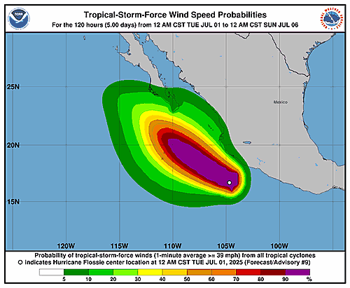
089
WTPZ31 KNHC 291139
TCPEP1

BULLETIN
Tropical Depression Six-E Intermediate Advisory Number 1A
NWS National Hurricane Center Miami FL       EP062025
600 AM CST Sun Jun 29 2025

...DEPRESSION BECOMING BETTER ORGANIZED...


SUMMARY OF 600 AM CST...1200 UTC...INFORMATION
----------------------------------------------
LOCATION...13.2N 99.7W
ABOUT 255 MI...410 KM S OF ACAPULCO MEXICO
ABOUT 500 MI...810 KM SE OF MANZANILLO MEXICO
MAXIMUM SUSTAINED WINDS...35 MPH...55 KM/H
PRESENT MOVEMENT...W OR 275 DEGREES AT 12 MPH...19 KM/H
MINIMUM CENTRAL PRESSURE...1006 MB...29.71 INCHES


WATCHES AND WARNINGS
--------------------
CHANGES WITH THIS ADVISORY:

None.

SUMMARY OF WATCHES AND WARNINGS IN EFFECT:

A Tropical Storm Watch is in effect for...
* Southwest coast of Mexico from Zihuatanejo to Manzanillo

A Tropical Storm Watch means that tropical storm conditions are
possible within the watch area, generally within 48 hours.

Interests elsewhere in southwestern Mexico should monitor the
progress of Tropical Depression Six-E.

For storm information specific to your area, please monitor
products issued by your national meteorological service.


DISCUSSION AND OUTLOOK
----------------------
At 600 AM CST (1200 UTC), the center of Tropical Depression Six-E
was located near latitude 13.2 North, longitude 99.7 West. The
depression is moving toward the west near 12 mph (19 km/h). A
west-northwestward to northwestward motion should begin later today
and continue through the next few days.

Maximum sustained winds have increased to near 35 mph (55 km/h) with
higher gusts. Gradual strengthening is forecast today, followed by
steady to rapid strengthening thereafter, and the system is expected
to become a hurricane on Tuesday.

The estimated minimum central pressure is 1006 mb (29.71 inches).


HAZARDS AFFECTING LAND
----------------------
RAINFALL: Tropical Depression Six-E is expected to produce rainfall
totals of 3 to 6 inches, with isolated maximum totals of 10 inches,
across portions of the Mexican states of Oaxaca, Guerrero,
Michoacán, Colima, and Jalisco through early next week. This
rainfall may lead to areas of life-threatening flooding and
mudslides, especially in areas of steep terrain.

For a complete depiction of forecast rainfall associated with
Tropical Depression Six-E, please see the National Weather Service
Storm Total Rainfall Graphic available at
hurricanes.gov/graphics_ep6.shtml?rainqpf

WIND: Tropical storm conditions are possible along the coast within
the watch area Monday and Tuesday.

SURF: Swells generated by Tropical Depression Six-E will begin
increasing along the coast of southwestern Mexico Monday and
continue into mid-week. These swells are likely to cause
life-threatening surf and rip current conditions.  Please consult
products from your local weather office.


NEXT ADVISORY
-------------
Next complete advisory at 900 AM CST.

$$
Forecaster Kelly
5-Day Uncertainty Track last updated Sun, 29 Jun 2025 08:34:35 GMT
Wind Speed Probabilities last updated Sun, 29 Jun 2025 09:21:19 GMT
5-Day Uncertainty Track last updated Sun, 29 Jun 2025 08:45:28 GMT
Wind Speed Probabilities last updated Sun, 29 Jun 2025 09:26:26 GMT
5-Day Uncertainty Track last updated Sun, 29 Jun 2025 08:34:35 GMT
Wind Speed Probabilities last updated Sun, 29 Jun 2025 08:34:35 GMT
Issued at 300 AM CST Sun Jun 29 2025
000
WTPZ41 KNHC 290834
TCDEP1

Tropical Depression Six-E Discussion Number   1
NWS National Hurricane Center Miami FL       EP062025
300 AM CST Sun Jun 29 2025

The convection associated with the area of low pressure located
south of southern Mexico has become much better organized over the
past 12 hours.  Additionally, a 29/0328 UTC ASCAT-C pass showed a
well-defined, closed low-level circulation with maximum winds around
25 kt.  The latest subjective Dvorak current intensity estimates
from TAFB and SAB are T-2.5 and T-2.0, respectively.  The
disturbance is upgraded to a tropical depression based on the
development of organized convection and a well-defined center.

The aforementioned ASCAT pass shows that Tropical Depression Six-E
has a large RMW.  However, the cyclone is located within a favorable
environment with warm SSTs, a moist mid-level troposphere and low to
moderate vertical wind shear.  The depression is forecast to remain
in these favorable conditions for another 3 to 4 days as it
parallels the coast of Mexico.  Due to the large RMW, only slow
strengthening is forecast for the first 24 h.  The system is
expected to strengthen more quickly once it establishes a stronger
convective core, and rapid intensification appears likely to occur
by Tuesday.  The NHC intensity forecast is at the high end of the
intensity guidance, especially at 60-72 h, and calls for the
system to become a significant hurricane.  By 96 h, the cyclone
should reach cooler water, and rapid weakening is likely in 4 to 5
days, with the system likely becoming a remnant low around day 5.

The current motion of the depression is estimated to be westward, or
270/10 kt.   The cyclone is forecast to generally move in a
direction between west-northwest and northwest for the next few
days, toward a weakness in the subtropical ridge, and the model
guidance is in good agreement on this general scenario.  The NHC
forecast is down the middle of the guidance envelope, close to the
TVCE consensus.

Residents of Mexico should stay updated on the latest forecast.  A
track even a little to the right of the official forecast would
bring more significant impacts to the coast of southwestern Mexico.


FORECAST POSITIONS AND MAX WINDS

INIT  29/0900Z 13.0N  99.5W   25 KT  30 MPH
 12H  29/1800Z 13.4N 100.3W   30 KT  35 MPH
 24H  30/0600Z 14.5N 101.5W   35 KT  40 MPH
 36H  30/1800Z 15.7N 103.0W   45 KT  50 MPH
 48H  01/0600Z 16.8N 104.6W   60 KT  70 MPH
 60H  01/1800Z 17.8N 106.2W   75 KT  85 MPH
 72H  02/0600Z 18.8N 107.5W   85 KT 100 MPH
 96H  03/0600Z 20.9N 109.9W   65 KT  75 MPH
120H  04/0600Z 22.6N 112.1W   40 KT  45 MPH...POST-TROPICAL

$$
Forecaster Hagen
5-Day Uncertainty Track last updated Sun, 29 Jun 2025 08:45:28 GMT
Wind Speed Probabilities last updated Sun, 29 Jun 2025 08:45:28 GMT
Issued at 0900 UTC SUN JUN 29 2025
452
FONT12 KNHC 290833
PWSAT2

TROPICAL DEPRESSION TWO WIND SPEED PROBABILITIES NUMBER   3
NWS NATIONAL HURRICANE CENTER MIAMI FL       AL022025
0900 UTC SUN JUN 29 2025

AT 0900Z THE CENTER OF TROPICAL DEPRESSION TWO WAS LOCATED NEAR
LATITUDE 19.9 NORTH...LONGITUDE 95.9 WEST WITH MAXIMUM SUSTAINED
WINDS NEAR 30 KTS...35 MPH...55 KM/H.

Z INDICATES COORDINATED UNIVERSAL TIME (GREENWICH)
   ATLANTIC STANDARD TIME (AST)...SUBTRACT 4 HOURS FROM Z TIME
   EASTERN  DAYLIGHT TIME (EDT)...SUBTRACT 4 HOURS FROM Z TIME
   CENTRAL  DAYLIGHT TIME (CDT)...SUBTRACT 5 HOURS FROM Z TIME

WIND SPEED PROBABILITY TABLE FOR SPECIFIC LOCATIONS

CHANCES OF SUSTAINED (1-MINUTE AVERAGE) WIND SPEEDS OF AT LEAST
   ...34 KT (39 MPH... 63 KM/H)...
   ...50 KT (58 MPH... 93 KM/H)...
   ...64 KT (74 MPH...119 KM/H)...
FOR LOCATIONS AND TIME PERIODS DURING THE NEXT 5 DAYS

PROBABILITIES FOR LOCATIONS ARE GIVEN AS OP(CP) WHERE
    OP  IS THE PROBABILITY OF THE EVENT BEGINNING DURING
        AN INDIVIDUAL TIME PERIOD (ONSET PROBABILITY)
   (CP) IS THE PROBABILITY OF THE EVENT OCCURRING BETWEEN
        06Z SUN AND THE FORECAST HOUR (CUMULATIVE PROBABILITY)

PROBABILITIES ARE GIVEN IN PERCENT
X INDICATES PROBABILITIES LESS THAN 1 PERCENT
PROBABILITIES FOR 34 KT AND 50 KT ARE SHOWN AT A GIVEN LOCATION WHEN
THE 5-DAY CUMULATIVE PROBABILITY IS AT LEAST 3 PERCENT.
PROBABILITIES FOR 34...50...64 KT SHOWN WHEN THE 5-DAY
64-KT CUMULATIVE PROBABILITY IS AT LEAST 1 PERCENT.


  - - - - WIND SPEED PROBABILITIES FOR SELECTED LOCATIONS - - - -

               FROM    FROM    FROM    FROM    FROM    FROM    FROM
  TIME       06Z SUN 18Z SUN 06Z MON 18Z MON 06Z TUE 06Z WED 06Z THU
PERIODS         TO      TO      TO      TO      TO      TO      TO
             18Z SUN 06Z MON 18Z MON 06Z TUE 06Z WED 06Z THU 06Z FRI

FORECAST HOUR    (12)   (24)    (36)    (48)    (72)    (96)   (120)
- - - - - - - - - - - - - - - - - - - - - - - - - - - - - - - - - -
LOCATION       KT

TAMPICO MX     34  X   3( 3)   X( 3)   X( 3)   X( 3)   X( 3)   X( 3)

TUXPAN MX      34  1   3( 4)   X( 4)   X( 4)   X( 4)   X( 4)   X( 4)

$$
FORECASTER CANGIALOSI
Issued at 400 AM CDT Sun Jun 29 2025
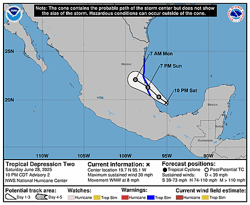
103
WTNT42 KNHC 290833
TCDAT2

Tropical Depression Two Discussion Number   3
NWS National Hurricane Center Miami FL       AL022025
400 AM CDT Sun Jun 29 2025

The Air Force Hurricane Hunters have been investigating the
depression over the Bay of Campeche this morning and found that the
system is quite disorganized.  In fact, the depression may not even
have a well-defined circulation.  Even though the structure of the
system is poorly organized, the aircraft data and ship observations
indicate that the winds have increased some.  Based on that
information, the initial intensity is nudged upward to 30 kt.

The depression has been moving a little to the south of the previous
forecast, and the latest initial motion estimate is 290/8 kt.  The
system is expected to turn northwestward later today as it tracks
along the western periphery of a low- to mid-level ridge.  This
motion should take the cyclone inland over eastern Mexico late today
or tonight.  Most of the strong winds are expected to occur to the
north of the center along the coast within the tropical storm
warning area this afternoon through early Monday.

Some slight additional strengthening is possible before the system
moves inland.  However, none of the models show much intensification
and given the poor initial structure and limited time over water,
significant strengthening seems highly unlikely.  The system is
expected to dissipate over the rugged terrain of eastern Mexico on
Monday.

Key Messages:

1. Tropical Depression Two will produce heavy rainfall across
portions of northeastern Mexico.  Life-threatening flooding and
mudslides, especially in areas of steep terrain, are possible.

2. Tropical storm conditions, especially in gusts, are expected
later today and tonight over portions of eastern Mexico in the
tropical storm warning area.

FORECAST POSITIONS AND MAX WINDS

INIT  29/0900Z 19.9N  95.9W   30 KT  35 MPH
 12H  29/1800Z 20.6N  96.9W   35 KT  40 MPH
 24H  30/0600Z 21.6N  98.0W   30 KT  35 MPH
 36H  30/1800Z...DISSIPATED

$$
Forecaster Cangialosi
Issued at 0900 UTC SUN JUN 29 2025
408
WTNT22 KNHC 290832
TCMAT2

TROPICAL DEPRESSION TWO FORECAST/ADVISORY NUMBER   3
NWS NATIONAL HURRICANE CENTER MIAMI FL       AL022025
0900 UTC SUN JUN 29 2025

TROPICAL DEPRESSION CENTER LOCATED NEAR 19.9N  95.9W AT 29/0900Z
POSITION ACCURATE WITHIN  30 NM

PRESENT MOVEMENT TOWARD THE WEST-NORTHWEST OR 290 DEGREES AT   8 KT

ESTIMATED MINIMUM CENTRAL PRESSURE 1010 MB
MAX SUSTAINED WINDS  30 KT WITH GUSTS TO  40 KT.
WINDS AND SEAS VARY GREATLY IN EACH QUADRANT.  RADII IN NAUTICAL
MILES ARE THE LARGEST RADII EXPECTED ANYWHERE IN THAT QUADRANT.

REPEAT...CENTER LOCATED NEAR 19.9N  95.9W AT 29/0900Z
AT 29/0600Z CENTER WAS LOCATED NEAR 19.7N  95.6W

FORECAST VALID 29/1800Z 20.6N  96.9W
MAX WIND  35 KT...GUSTS  45 KT.
34 KT... 60NE   0SE   0SW   0NW.

FORECAST VALID 30/0600Z 21.6N  98.0W
MAX WIND  30 KT...GUSTS  40 KT.

FORECAST VALID 30/1800Z...DISSIPATED

REQUEST FOR 3 HOURLY SHIP REPORTS WITHIN 300 MILES OF 19.9N  95.9W

INTERMEDIATE PUBLIC ADVISORY...WTNT32 KNHC/MIATCPAT2...AT 29/1200Z

NEXT ADVISORY AT 29/1500Z

$$
FORECASTER CANGIALOSI
Issued at 400 AM CDT Sun Jun 29 2025
797
WTNT32 KNHC 290833
TCPAT2

BULLETIN
Tropical Depression Two Advisory Number   3
NWS National Hurricane Center Miami FL       AL022025
400 AM CDT Sun Jun 29 2025

...HEAVY RAINS BEGINNING TO SPREAD ACROSS PORTIONS OF EASTERN
MEXICO...


SUMMARY OF 400 AM CDT...0900 UTC...INFORMATION
----------------------------------------------
LOCATION...19.9N 95.9W
ABOUT 50 MI...85 KM NNE OF VERACRUZ MEXICO
ABOUT 125 MI...200 KM SE OF TUXPAN MEXICO
MAXIMUM SUSTAINED WINDS...35 MPH...55 KM/H
PRESENT MOVEMENT...WNW OR 290 DEGREES AT 9 MPH...15 KM/H
MINIMUM CENTRAL PRESSURE...1010 MB...29.83 INCHES


WATCHES AND WARNINGS
--------------------
CHANGES WITH THIS ADVISORY:

None.

SUMMARY OF WATCHES AND WARNINGS IN EFFECT:

A Tropical Storm Warning is in effect for...
* Gulf coast of Mexico from Boca de Catan southward to Tecolutla

A Tropical Storm Warning means that tropical storm conditions are
expected somewhere within the warning area, in this case within 24
hours.

For storm information specific to your area, please monitor
products issued by your national meteorological service.


DISCUSSION AND OUTLOOK
----------------------
At 400 AM CDT (0900 UTC), the center of Tropical Depression Two was
located near latitude 19.9 North, longitude 95.9 West. The
depression is moving toward the west-northwest near 9 mph (15
km/h).  A turn to the northwest is expected later today.  On the
forecast track, the system is expected to move inland over eastern
Mexico late today or tonight.

Maximum sustained winds are near 35 mph (55 km/h) with higher gusts.
Some slight additional strengthening is possible before the system
reaches the coast of eastern Mexico.

The estimated minimum central pressure is 1010 mb (29.83 inches).


HAZARDS AFFECTING LAND
----------------------
Key messages for Tropical Depression Two can be found in the
Tropical Cyclone Discussion under AWIPS header MIATCDAT2 and WMO
header WTNT42 KNHC.

RAINFALL: Tropical Depression Two is expected to produce rainfall
totals of 3 to 6 inches, with isolated maximum totals of 10 inches,
across the Mexican states of Veracruz, San Luis Potosi, and
Tamaulipas through Monday. This rainfall may produce
life-threatening flooding and mudslides, especially in areas of
steep terrain.

For a complete depiction of forecast rainfall and flash flooding
associated with Tropical Depression Two, please see the National
Weather Service Storm Total Rainfall Graphic, available at
hurricanes.gov/graphics_at2.shtml?rainqpf

WIND: Tropical storm conditions, especially in gusts, are expected
in the tropical storm warning area beginning this afternoon.


NEXT ADVISORY
-------------
Next intermediate advisory at 700 AM CDT.
Next complete advisory at 1000 AM CDT.

$$
Forecaster Cangialosi
5-Day Uncertainty Track last updated Sun, 29 Jun 2025 05:49:58 GMT
Wind Speed Probabilities last updated Sun, 29 Jun 2025 03:21:56 GMT
5-Day Uncertainty Track last updated Sun, 29 Jun 2025 05:49:58 GMT
Wind Speed Probabilities last updated Sun, 29 Jun 2025 03:21:56 GMT
Issued at 100 AM CDT Sun Jun 29 2025
000
WTNT32 KNHC 290549
TCPAT2

BULLETIN
Tropical Depression Two Intermediate Advisory Number 2A
NWS National Hurricane Center Miami FL       AL022025
100 AM CDT Sun Jun 29 2025

...DEPRESSION EXPECTED TO PRODUCE HEAVY RAINS OVER PORTIONS OF
EASTERN MEXICO...


SUMMARY OF 100 AM CDT...0600 UTC...INFORMATION
----------------------------------------------
LOCATION...19.7N 95.7W
ABOUT 60 MI...95 KM NE OF VERACRUZ MEXICO
ABOUT 135 MI...215 KM SE OF TUXPAN MEXICO
MAXIMUM SUSTAINED WINDS...30 MPH...45 KM/H
PRESENT MOVEMENT...WNW OR 295 DEGREES AT 8 MPH...13 KM/H
MINIMUM CENTRAL PRESSURE...1011 MB...29.86 INCHES


WATCHES AND WARNINGS
--------------------
CHANGES WITH THIS ADVISORY:

None.

SUMMARY OF WATCHES AND WARNINGS IN EFFECT:

A Tropical Storm Warning is in effect for...
* Gulf coast of Mexico from Boca de Catan southward to Tecolutla

A Tropical Storm Warning means that tropical storm conditions are
expected somewhere within the warning area within 36 hours.

For storm information specific to your area, please monitor
products issued by your national meteorological service.


DISCUSSION AND OUTLOOK
----------------------
At 100 AM CDT (0600 UTC), the center of Tropical Depression Two was
located near latitude 19.7 North, longitude 95.7 West. The
depression is moving toward the west-northwest near 8 mph (13 km/h)
and this general motion is anticipated to continue for the next day
or two. On the forecast track, the depression is expected to make
landfall along the eastern coast of Mexico tonight and move inland
early Monday.

Maximum sustained winds are near 30 mph (45 km/h) with higher gusts.
Some gradual strengthening is expected through tonight, and the
depression is forecast to become a tropical storm before it reaches
the coast of Mexico.  Weakening is expected after landfall, and the
system is forecast to dissipate over eastern Mexico on Monday.

The estimated minimum central pressure is 1011 mb (29.86 inches).


HAZARDS AFFECTING LAND
----------------------
Key messages for Tropical Depression Two can be found in the
Tropical Cyclone Discussion under AWIPS header MIATCDAT2 and WMO
header WTNT42 KNHC.

RAINFALL: Tropical Depression Two is expected to produce rainfall
totals of 3 to 6 inches, with maximum totals of 10 inches possible
across the Mexican states of Veracruz, San Luis Potosi, and
Tamaulipas.  This rainfall may produce life-threatening flooding and
mudslides, especially in areas of steep terrain.

For a complete depiction of forecast rainfall and flash flooding
associated with Tropical Depression Two, please see the National
Weather Service Storm Total Rainfall Graphic, available at
hurricanes.gov/graphics_at2.shtml?rainqpf

WIND: Tropical storm conditions are expected in the tropical storm
warning area beginning this afternoon.


NEXT ADVISORY
-------------
Next complete advisory at 400 AM CDT.

$$
Forecaster Cangialosi
5-Day Uncertainty Track last updated Sun, 29 Jun 2025 02:34:17 GMT
Wind Speed Probabilities last updated Sun, 29 Jun 2025 03:21:56 GMT
Issued at 0300 UTC SUN JUN 29 2025
469
FONT12 KNHC 290232
PWSAT2

TROPICAL DEPRESSION TWO WIND SPEED PROBABILITIES NUMBER   2
NWS NATIONAL HURRICANE CENTER MIAMI FL       AL022025
0300 UTC SUN JUN 29 2025

AT 0300Z THE CENTER OF TROPICAL DEPRESSION TWO WAS LOCATED NEAR
LATITUDE 19.7 NORTH...LONGITUDE 95.1 WEST WITH MAXIMUM SUSTAINED
WINDS NEAR 25 KTS...30 MPH...45 KM/H.

Z INDICATES COORDINATED UNIVERSAL TIME (GREENWICH)
   ATLANTIC STANDARD TIME (AST)...SUBTRACT 4 HOURS FROM Z TIME
   EASTERN  DAYLIGHT TIME (EDT)...SUBTRACT 4 HOURS FROM Z TIME
   CENTRAL  DAYLIGHT TIME (CDT)...SUBTRACT 5 HOURS FROM Z TIME

WIND SPEED PROBABILITY TABLE FOR SPECIFIC LOCATIONS

CHANCES OF SUSTAINED (1-MINUTE AVERAGE) WIND SPEEDS OF AT LEAST
   ...34 KT (39 MPH... 63 KM/H)...
   ...50 KT (58 MPH... 93 KM/H)...
   ...64 KT (74 MPH...119 KM/H)...
FOR LOCATIONS AND TIME PERIODS DURING THE NEXT 5 DAYS

PROBABILITIES FOR LOCATIONS ARE GIVEN AS OP(CP) WHERE
    OP  IS THE PROBABILITY OF THE EVENT BEGINNING DURING
        AN INDIVIDUAL TIME PERIOD (ONSET PROBABILITY)
   (CP) IS THE PROBABILITY OF THE EVENT OCCURRING BETWEEN
        00Z SUN AND THE FORECAST HOUR (CUMULATIVE PROBABILITY)

PROBABILITIES ARE GIVEN IN PERCENT
X INDICATES PROBABILITIES LESS THAN 1 PERCENT
PROBABILITIES FOR 34 KT AND 50 KT ARE SHOWN AT A GIVEN LOCATION WHEN
THE 5-DAY CUMULATIVE PROBABILITY IS AT LEAST 3 PERCENT.
PROBABILITIES FOR 34...50...64 KT SHOWN WHEN THE 5-DAY
64-KT CUMULATIVE PROBABILITY IS AT LEAST 1 PERCENT.


  - - - - WIND SPEED PROBABILITIES FOR SELECTED LOCATIONS - - - -

               FROM    FROM    FROM    FROM    FROM    FROM    FROM
  TIME       00Z SUN 12Z SUN 00Z MON 12Z MON 00Z TUE 00Z WED 00Z THU
PERIODS         TO      TO      TO      TO      TO      TO      TO
             12Z SUN 00Z MON 12Z MON 00Z TUE 00Z WED 00Z THU 00Z FRI

FORECAST HOUR    (12)   (24)    (36)    (48)    (72)    (96)   (120)
- - - - - - - - - - - - - - - - - - - - - - - - - - - - - - - - - -
LOCATION       KT

TAMPICO MX     34  X   1( 1)   2( 3)   X( 3)   X( 3)   X( 3)   X( 3)

TUXPAN MX      34  X   3( 3)   X( 3)   X( 3)   X( 3)   X( 3)   X( 3)

$$
FORECASTER BEVEN
5-Day Uncertainty Track last updated Sun, 29 Jun 2025 02:34:17 GMT
Wind Speed Probabilities last updated Sun, 29 Jun 2025 02:34:17 GMT
Issued at 1000 PM CDT Sat Jun 28 2025
199
WTNT32 KNHC 290232
TCPAT2

BULLETIN
Tropical Depression Two Advisory Number   2
NWS National Hurricane Center Miami FL       AL022025
1000 PM CDT Sat Jun 28 2025

...POORLY ORGANIZED DEPRESSION MOVING WEST-NORTHWESTWARD ACROSS THE
BAY OF CAMPECHE...


SUMMARY OF 1000 PM CDT...0300 UTC...INFORMATION
-----------------------------------------------
LOCATION...19.7N 95.1W
ABOUT 175 MI...280 KM ESE OF TUXPAN MEXICO
ABOUT 80 MI...130 KM ENE OF VERACRUZ MEXICO
MAXIMUM SUSTAINED WINDS...30 MPH...45 KM/H
PRESENT MOVEMENT...WNW OR 295 DEGREES AT 8 MPH...13 KM/H
MINIMUM CENTRAL PRESSURE...1011 MB...29.86 INCHES


WATCHES AND WARNINGS
--------------------
CHANGES WITH THIS ADVISORY:

None.

SUMMARY OF WATCHES AND WARNINGS IN EFFECT:

A Tropical Storm Warning is in effect for...
* Gulf coast of Mexico from Boca de Catan southward to Tecolutla

A Tropical Storm Warning means that tropical storm conditions are
expected somewhere within the warning area within 36 hours.

For storm information specific to your area, please monitor
products issued by your national meteorological service.


DISCUSSION AND OUTLOOK
----------------------
At 1000 PM CDT (0300 UTC), the center of Tropical Depression Two was
located near latitude 19.7 North, longitude 95.1 West. The
depression is moving toward the west-northwest near 8 mph (13 km/h)
and this general motion is expected to continue for the next day or
two. On the forecast track, the depression is expected to make
landfall along the Mexico coast Sunday night and move further
inland on Monday.

Maximum sustained winds are near 30 mph (45 km/h) with higher gusts.
Some intensification is expected over the next day or so, and
the depression is forecast to become a tropical storm before
reaching the coast of Mexico.  Weakening is expected after
landfall, and the system is forecast to dissipate over eastern
Mexico on Monday.

The estimated minimum central pressure is 1011 mb (29.86 inches).


HAZARDS AFFECTING LAND
----------------------
Key messages for Tropical Depression Two can be found in the
Tropical Cyclone Discussion under AWIPS header MIATCDAT2 and WMO
header WTNT42 KNHC.

RAINFALL: Tropical Depression Two is expected to produce rainfall
totals of 3 to 6 inches, with maximum totals of 10 inches possible
across the Mexican states of Veracruz, San Luis Potosi, and
Tamaulipas.  This rainfall may produce life-threatening flooding and
mudslides, especially in areas of steep terrain.

For a complete depiction of forecast rainfall and flash flooding
associated with Potential Tropical Cyclone Two, please see the
National Weather Service Storm Total Rainfall Graphic, available at
hurricanes.gov/graphics_at2.shtml?rainqpf

WIND: Tropical Storm conditions are expected in the tropical storm
warning area beginning Sunday afternoon.


NEXT ADVISORY
-------------
Next intermediate advisory at 100 AM CDT.
Next complete advisory at 400 AM CDT.

$$
Forecaster Beven
Issued at 0300 UTC SUN JUN 29 2025
198
WTNT22 KNHC 290232
TCMAT2

TROPICAL DEPRESSION TWO FORECAST/ADVISORY NUMBER   2
NWS NATIONAL HURRICANE CENTER MIAMI FL       AL022025
0300 UTC SUN JUN 29 2025

TROPICAL DEPRESSION CENTER LOCATED NEAR 19.7N  95.1W AT 29/0300Z
POSITION ACCURATE WITHIN  30 NM

PRESENT MOVEMENT TOWARD THE WEST-NORTHWEST OR 295 DEGREES AT   7 KT

ESTIMATED MINIMUM CENTRAL PRESSURE 1011 MB
MAX SUSTAINED WINDS  25 KT WITH GUSTS TO  35 KT.
WINDS AND SEAS VARY GREATLY IN EACH QUADRANT.  RADII IN NAUTICAL
MILES ARE THE LARGEST RADII EXPECTED ANYWHERE IN THAT QUADRANT.

REPEAT...CENTER LOCATED NEAR 19.7N  95.1W AT 29/0300Z
AT 29/0000Z CENTER WAS LOCATED NEAR 19.5N  94.7W

FORECAST VALID 29/1200Z 20.3N  96.0W
MAX WIND  30 KT...GUSTS  40 KT.

FORECAST VALID 30/0000Z 21.3N  97.3W
MAX WIND  35 KT...GUSTS  45 KT.
34 KT... 40NE  30SE   0SW   0NW.

FORECAST VALID 30/1200Z 22.1N  98.8W...INLAND
MAX WIND  25 KT...GUSTS  35 KT.

FORECAST VALID 01/0000Z...DISSIPATED

REQUEST FOR 3 HOURLY SHIP REPORTS WITHIN 300 MILES OF 19.7N  95.1W

INTERMEDIATE PUBLIC ADVISORY...WTNT32 KNHC/MIATCPAT2...AT 29/0600Z

NEXT ADVISORY AT 29/0900Z

$$
FORECASTER BEVEN
Issued at 1000 PM CDT Sat Jun 28 2025
554
WTNT42 KNHC 290232
TCDAT2

Tropical Depression Two Discussion Number   2
NWS National Hurricane Center Miami FL       AL022025
1000 PM CDT Sat Jun 28 2025

Tropical Depression Two is poorly organized at this time. During
the latter part of the Hurricane Hunter Mission this afternoon, the
aircraft was unable to close off the circulation. Since that time,
conventional satellite imagery and 2235 UTC SSM/IS overpass show
little change in organization, although surface observations
suggest the circulation is still closed. The initial intensity is
held at 25 kt in agreement with current satellite intensity
estimates.

The initial motion is a somewhat uncertain 295/7. The subtropical
ridge to the east and northeast of the cyclone should steer the
system generally west-northwestward for the next couple of days,
bringing the center to the eastern coast of Mexico near the 24 h
point.  There is little change in either the track guidance or the
track forecast since the last advisory.  It should be noted that
some erratic motion could occur as the circulation interacts with
the coast of Mexico.

The cyclone is experiencing 20-25 kt of southwesterly vertical
shear. However, the upper-level winds are divergent, which should
allow the system to produce significant convection.  It is expected
that this convection will lead to a little strengthening despite
the shear, and based on this the depression is forecast to become a
tropical storm near the time of landfall.  After landfall, the
cyclone is expected to rapidly weaken over eastern Mexico.

Given the forecast for the depression to become a tropical storm
before landfall, a Tropical Storm Warning is in effect for a
portion of their eastern Gulf coastline of Mexico.

Key Messages:

1. Tropical storm conditions are expected on Sunday for portions of
the Gulf coast of Mexico where a Tropical Storm Warning is in
effect.

2. Tropical Depression Two will produce heavy rainfall across
portions of northeastern Mexico. Life-threatening flooding and
mudslides, especially in areas of steep terrain, are possible.


FORECAST POSITIONS AND MAX WINDS

INIT  29/0300Z 19.7N  95.1W   25 KT  30 MPH
 12H  29/1200Z 20.3N  96.0W   30 KT  35 MPH
 24H  30/0000Z 21.3N  97.3W   35 KT  40 MPH
 36H  30/1200Z 22.1N  98.8W   25 KT  30 MPH...INLAND
 48H  01/0000Z...DISSIPATED

$$
Forecaster Beven
5-Day Uncertainty Track last updated Sat, 28 Jun 2025 23:34:48 GMT
Wind Speed Probabilities last updated Sat, 28 Jun 2025 21:21:18 GMT
Issued at 700 PM CDT Sat Jun 28 2025
918
WTNT32 KNHC 282332
TCPAT2

BULLETIN
Tropical Depression Two Intermediate Advisory Number 1A
NWS National Hurricane Center Miami FL       AL022025
700 PM CDT Sat Jun 28 2025

...TROPICAL DEPRESSION MOVING WEST-NORTHWESTWARD ACROSS THE BAY
OF CAMPECHE...


SUMMARY OF 700 PM CDT...0000 UTC...INFORMATION
----------------------------------------------
LOCATION...19.5N 94.7W
ABOUT 210 MI...340 KM ESE OF TUXPAN MEXICO
ABOUT 100 MI...160 KM ENE OF VERACRUZ MEXICO
MAXIMUM SUSTAINED WINDS...30 MPH...45 KM/H
PRESENT MOVEMENT...WNW OR 290 DEGREES AT 7 MPH...11 KM/H
MINIMUM CENTRAL PRESSURE...1011 MB...29.86 INCHES


WATCHES AND WARNINGS
--------------------
CHANGES WITH THIS ADVISORY:

None.

SUMMARY OF WATCHES AND WARNINGS IN EFFECT:

A Tropical Storm Warning is in effect for...
* Gulf coast of Mexico from Boca de Catan southward to Tecolutla

A Tropical Storm Warning means that tropical storm conditions are
expected somewhere within the warning area within 36 hours.

For storm information specific to your area, please monitor
products issued by your national meteorological service.


DISCUSSION AND OUTLOOK
----------------------
At 700 PM CDT (0000 UTC), the center of Tropical Depression Two was
located near latitude 19.5 North, longitude 94.7 West. The
depression is moving toward the west-northwest near 7 mph (11 km/h)
and this motion is expected to continue for the next day or two. On
the following track the depression is expected to make landfall
along the Mexico coast on Sunday night and move further inland on
Monday.

Maximum sustained winds are near 30 mph (45 km/h) with higher
gusts. Some intensification is forecast over the next day or so, and
the depression is forecast to become a tropical storm before
reaching the coast of Mexico.

The minimum central pressure estimated by Air Force Reserve
Reconnaissance data is 1011 mb (29.86 inches).


HAZARDS AFFECTING LAND
----------------------
Key messages for Tropical Depression Two can be found in the
Tropical Cyclone Discussion under AWIPS header MIATCDAT2 and WMO
header WTNT42 KNHC.

RAINFALL: Tropical Depression Two is expected to produce rainfall
totals of 3 to 6 inches, with maximum totals of 10 inches possible
across the Mexican states of Veracruz, San Luis Potosi, and
Tamaulipas.  This rainfall may produce isolated flash and urban
flooding.

For a complete depiction of forecast rainfall and flash flooding
associated with Tropical Depression Two, please see the National
Weather Service Storm Total Rainfall Graphic, available at
hurricanes.gov/graphics_at2.shtml?rainqpf

WIND: Tropical Storm conditions are expected in the tropical storm
warning area beginning Sunday afternoon.


NEXT ADVISORY
-------------
Next complete advisory at 1000 PM CDT.

$$
Forecaster Beven
5-Day Uncertainty Track last updated Sat, 28 Jun 2025 20:58:04 GMT
Wind Speed Probabilities last updated Sat, 28 Jun 2025 21:21:18 GMT
Issued at 2100 UTC SAT JUN 28 2025
738
FONT12 KNHC 282051
PWSAT2

TROPICAL DEPRESSION TWO WIND SPEED PROBABILITIES NUMBER   1
NWS NATIONAL HURRICANE CENTER MIAMI FL       AL022025
2100 UTC SAT JUN 28 2025

AT 2100Z THE CENTER OF TROPICAL DEPRESSION TWO WAS LOCATED NEAR
LATITUDE 19.3 NORTH...LONGITUDE 94.2 WEST WITH MAXIMUM SUSTAINED
WINDS NEAR 25 KTS...30 MPH...45 KM/H.

Z INDICATES COORDINATED UNIVERSAL TIME (GREENWICH)
   ATLANTIC STANDARD TIME (AST)...SUBTRACT 4 HOURS FROM Z TIME
   EASTERN  DAYLIGHT TIME (EDT)...SUBTRACT 4 HOURS FROM Z TIME
   CENTRAL  DAYLIGHT TIME (CDT)...SUBTRACT 5 HOURS FROM Z TIME

WIND SPEED PROBABILITY TABLE FOR SPECIFIC LOCATIONS

CHANCES OF SUSTAINED (1-MINUTE AVERAGE) WIND SPEEDS OF AT LEAST
   ...34 KT (39 MPH... 63 KM/H)...
   ...50 KT (58 MPH... 93 KM/H)...
   ...64 KT (74 MPH...119 KM/H)...
FOR LOCATIONS AND TIME PERIODS DURING THE NEXT 5 DAYS

PROBABILITIES FOR LOCATIONS ARE GIVEN AS OP(CP) WHERE
    OP  IS THE PROBABILITY OF THE EVENT BEGINNING DURING
        AN INDIVIDUAL TIME PERIOD (ONSET PROBABILITY)
   (CP) IS THE PROBABILITY OF THE EVENT OCCURRING BETWEEN
        18Z SAT AND THE FORECAST HOUR (CUMULATIVE PROBABILITY)

PROBABILITIES ARE GIVEN IN PERCENT
X INDICATES PROBABILITIES LESS THAN 1 PERCENT
PROBABILITIES FOR 34 KT AND 50 KT ARE SHOWN AT A GIVEN LOCATION WHEN
THE 5-DAY CUMULATIVE PROBABILITY IS AT LEAST 3 PERCENT.
PROBABILITIES FOR 34...50...64 KT SHOWN WHEN THE 5-DAY
64-KT CUMULATIVE PROBABILITY IS AT LEAST 1 PERCENT.


  - - - - WIND SPEED PROBABILITIES FOR SELECTED LOCATIONS - - - -

               FROM    FROM    FROM    FROM    FROM    FROM    FROM
  TIME       18Z SAT 06Z SUN 18Z SUN 06Z MON 18Z MON 18Z TUE 18Z WED
PERIODS         TO      TO      TO      TO      TO      TO      TO
             06Z SUN 18Z SUN 06Z MON 18Z MON 18Z TUE 18Z WED 18Z THU

FORECAST HOUR    (12)   (24)    (36)    (48)    (72)    (96)   (120)
- - - - - - - - - - - - - - - - - - - - - - - - - - - - - - - - - -
LOCATION       KT

TAMPICO MX     34  X   X( X)   6( 6)   1( 7)   X( 7)   X( 7)   X( 7)

TUXPAN MX      34  X   X( X)   5( 5)   X( 5)   X( 5)   X( 5)   X( 5)

VERACRUZ MX    34  2   1( 3)   1( 4)   X( 4)   X( 4)   X( 4)   X( 4)

$$
FORECASTER PAPIN
Issued at 400 PM CDT Sat Jun 28 2025
000
WTNT42 KNHC 282055
TCDAT2

Tropical Depression Two Discussion Number   1
NWS National Hurricane Center Miami FL       AL022025
400 PM CDT Sat Jun 28 2025

The area of low pressure that entered in the Bay of Campeche early
this morning (Invest 91L) has slowly improved in organization
through the day. Convection had been mostly bursting on the southern
portion of the circulation, but is more recently starting to fill in
over the northern side. An Air Force Reserve reconnaissance mission
has been sampling the system this afternoon, and they were able to
close off a circulation center, albeit with not a whole lot of wind.
This wind field matches the satellite-derived scatterometer wind
data at 1619 UTC which showed a closed circulation, but with peak
winds of only 24 kt. However, given the improvement in convective
organization with the well-defined circulation noted, advisories are
being initiated on Tropical Depression Two this afternoon, with
maximum sustained winds of 25 kt, matching the T1.5/25-kt estimate
provided by TAFB.

The initial motion of the tropical depression appears to be off to
the west-northwest at 290/6 kt. This motion with a slight bend a
little more northward is expected through the weekend until the
system moves inland over mainland Mexico just after 36 h. The track
guidance overall appears to be in pretty good agreement, though with
the ECMWF on the south end and GFS on the north end of the guidance
envelope. The initial NHC track forecast splits the difference and
is quite close to the latest TVCN and HCCA consensus aids.

The depression's wind field is still somewhat broad and in the
formative stages. In addition, the environmental conditions are not
ideal, with some 20-25 kt of west-southwesterly vertical wind shear
diagnosed by SHIPS guidance that should prevent more robust
intensification of this cyclone. On the other hand, sea-surface
temperatures are fairly warm (28-29 C) and there is ample mid-level
moisture to sustain the convective activity. Thus, some slow
intensification seems likely, and the intensity forecast shows the
depression becoming a tropical storm before making landfall in
Mexico. However, once inland after 36 h, the system should quickly
weaken and dissipate by the early portion of next week over the
rugged high terrain of central Mexico. This intensity forecast is
largely in good agreement with the consensus aid HCCA and the most
recent HWRF hurricane-regional model run.

Given the forecast for the depression to become a tropical storm
before landfall, the government of Mexico has issued a Tropical
Storm Warning for a portion of their eastern Gulf coastline.

Key Messages:

1. Tropical Storm Conditions are expected on Sunday for portions of
the Gulf coast of Mexico where a Tropical Storm Warning is in
effect.

2. Heavy rainfall associated with Tropical Depression Two will
impact portions of northeastern Mexico. This rainfall may produce
isolated flash and urban flooding.


FORECAST POSITIONS AND MAX WINDS

INIT  28/2100Z 19.3N  94.2W   25 KT  30 MPH
 12H  29/0600Z 19.7N  95.1W   30 KT  35 MPH
 24H  29/1800Z 20.8N  96.1W   35 KT  40 MPH
 36H  30/0600Z 21.9N  97.7W   35 KT  40 MPH
 48H  30/1800Z 22.1N  98.7W   20 KT  25 MPH...POST-TROP/INLAND
 60H  01/0600Z...DISSIPATED

$$
Forecaster Papin
5-Day Uncertainty Track last updated Sat, 28 Jun 2025 20:58:04 GMT
Wind Speed Probabilities last updated Sat, 28 Jun 2025 20:58:04 GMT
Issued at 400 PM CDT Sat Jun 28 2025
593
WTNT32 KNHC 282051
TCPAT2

BULLETIN
Tropical Depression Two Advisory Number   1
NWS National Hurricane Center Miami FL       AL022025
400 PM CDT Sat Jun 28 2025

...TROPICAL DEPRESSION TWO FORMS IN THE BAY OF CAMPECHE...


SUMMARY OF 400 PM CDT...2100 UTC...INFORMATION
----------------------------------------------
LOCATION...19.3N 94.2W
ABOUT 240 MI...385 KM ESE OF TUXPAN MEXICO
ABOUT 130 MI...210 KM E OF VERACRUZ MEXICO
MAXIMUM SUSTAINED WINDS...30 MPH...45 KM/H
PRESENT MOVEMENT...WNW OR 290 DEGREES AT 7 MPH...11 KM/H
MINIMUM CENTRAL PRESSURE...1011 MB...29.86 INCHES


WATCHES AND WARNINGS
--------------------
CHANGES WITH THIS ADVISORY:

The government of Mexico has issued a Tropical Storm Warning for
the Gulf coast of Mexico from Boca de Catan southward to Tecolutla.

SUMMARY OF WATCHES AND WARNINGS IN EFFECT:

A Tropical Storm Warning is in effect for...
* Gulf coast of Mexico from Boca de Catan southward to Tecolutla

A Tropical Storm Warning means that tropical storm conditions are
expected somewhere within the warning area within 36 hours.

For storm information specific to your area, please monitor
products issued by your national meteorological service.


DISCUSSION AND OUTLOOK
----------------------
At 400 PM CDT (2100 UTC), the center of Tropical Depression Two was
located near latitude 19.3 North, longitude 94.2 West. The
depression is moving toward the west-northwest near 7 mph (11 km/h)
and this motion is expected to continue for the next day or two. On
the following track the depression is expected to make landfall
along the Mexico coast on Sunday night and move further inland on
Monday.

Maximum sustained winds are near 30 mph (45 km/h) with higher gusts.
Some intensification is forecast over the next day or so, and the
depression is forecast to become a tropical storm before reaching
the coast of Mexico.

The minimum central pressure estimated by Air Force Reserve
Reconnaissance data is 1011 mb (29.86 inches).


HAZARDS AFFECTING LAND
----------------------
Key messages for Tropical Depression Two can be found in the
Tropical Cyclone Discussion under AWIPS header MIATCDAT2 and WMO
header WTNT42 KNHC.

RAINFALL: Tropical Depression Two is expected to produce rainfall
totals of 3 to 6 inches, with maximum totals of 10 inches possible
across the Mexican states of Veracruz, San Luis Potosi, and
Tamaulipas.  This rainfall may produce isolated flash and urban
flooding.

For a complete depiction of forecast rainfall and flash flooding
associated with Tropical Depression Two, please see the National
Weather Service Storm Total Rainfall Graphic, available at
hurricanes.gov/graphics_at2.shtml?rainqpf

WIND: Tropical Storm conditions are expected in the tropical storm
warning area beginning Sunday afternoon.


NEXT ADVISORY
-------------
Next intermediate advisory at 700 PM CDT.
Next complete advisory at 1000 PM CDT.

$$
Forecaster Papin
Issued at 2100 UTC SAT JUN 28 2025
000
WTNT22 KNHC 282046
TCMAT2

TROPICAL DEPRESSION TWO FORECAST/ADVISORY NUMBER   1
NWS NATIONAL HURRICANE CENTER MIAMI FL       AL022025
2100 UTC SAT JUN 28 2025

TROPICAL DEPRESSION CENTER LOCATED NEAR 19.3N  94.2W AT 28/2100Z
POSITION ACCURATE WITHIN  30 NM

PRESENT MOVEMENT TOWARD THE WEST-NORTHWEST OR 290 DEGREES AT   6 KT

ESTIMATED MINIMUM CENTRAL PRESSURE 1011 MB
MAX SUSTAINED WINDS  25 KT WITH GUSTS TO  35 KT.
WINDS AND SEAS VARY GREATLY IN EACH QUADRANT.  RADII IN NAUTICAL
MILES ARE THE LARGEST RADII EXPECTED ANYWHERE IN THAT QUADRANT.

REPEAT...CENTER LOCATED NEAR 19.3N  94.2W AT 28/2100Z
AT 28/1800Z CENTER WAS LOCATED NEAR 19.2N  93.9W

FORECAST VALID 29/0600Z 19.7N  95.1W
MAX WIND  30 KT...GUSTS  40 KT.

FORECAST VALID 29/1800Z 20.8N  96.1W
MAX WIND  35 KT...GUSTS  45 KT.
34 KT... 40NE  30SE   0SW   0NW.

FORECAST VALID 30/0600Z 21.9N  97.7W
MAX WIND  35 KT...GUSTS  45 KT.
34 KT... 60NE  50SE   0SW   0NW.

FORECAST VALID 30/1800Z 22.1N  98.7W...POST-TROP/INLAND
MAX WIND  20 KT...GUSTS  30 KT.

FORECAST VALID 01/0600Z...DISSIPATED

REQUEST FOR 3 HOURLY SHIP REPORTS WITHIN 300 MILES OF 19.3N  94.2W

INTERMEDIATE PUBLIC ADVISORY...WTNT32 KNHC/MIATCPAT2...AT 29/0000Z

NEXT ADVISORY AT 29/0300Z

$$
FORECASTER PAPIN
5-Day Uncertainty Track last updated Wed, 25 Jun 2025 02:46:51 GMT

Wind Speed Probabilities last updated Wed, 25 Jun 2025 03:21:57 GMT