Issued at 2100 UTC SUN JUN 29 2025
000
FOPZ11 KNHC 292037
PWSEP1
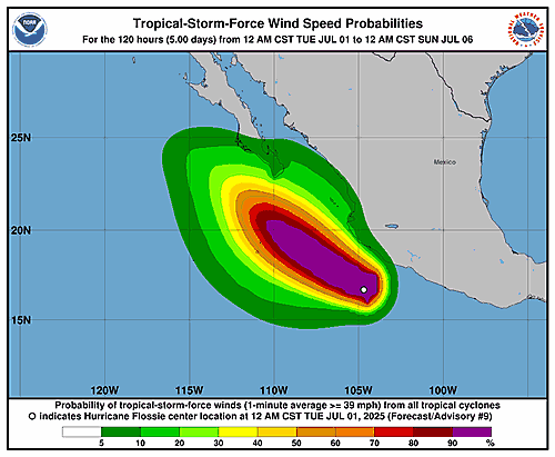
TROPICAL STORM FLOSSIE WIND SPEED PROBABILITIES NUMBER 3
NWS NATIONAL HURRICANE CENTER MIAMI FL EP062025
2100 UTC SUN JUN 29 2025
AT 2100Z THE CENTER OF TROPICAL STORM FLOSSIE WAS LOCATED NEAR
LATITUDE 13.5 NORTH...LONGITUDE 100.4 WEST WITH MAXIMUM SUSTAINED
WINDS NEAR 35 KTS...40 MPH...65 KM/H.
Z INDICATES COORDINATED UNIVERSAL TIME (GREENWICH)
PACIFIC DAYLIGHT TIME (PDT)...SUBTRACT 7 HOURS FROM Z TIME
HAWAIIAN STANDARD TIME (HST)...SUBTRACT 10 HOURS FROM Z TIME
WIND SPEED PROBABILITY TABLE FOR SPECIFIC LOCATIONS
CHANCES OF SUSTAINED (1-MINUTE AVERAGE) WIND SPEEDS OF AT LEAST
...34 KT (39 MPH... 63 KM/H)...
...50 KT (58 MPH... 93 KM/H)...
...64 KT (74 MPH...119 KM/H)...
FOR LOCATIONS AND TIME PERIODS DURING THE NEXT 5 DAYS
PROBABILITIES FOR LOCATIONS ARE GIVEN AS OP(CP) WHERE
OP IS THE PROBABILITY OF THE EVENT BEGINNING DURING
AN INDIVIDUAL TIME PERIOD (ONSET PROBABILITY)
(CP) IS THE PROBABILITY OF THE EVENT OCCURRING BETWEEN
18Z SUN AND THE FORECAST HOUR (CUMULATIVE PROBABILITY)
PROBABILITIES ARE GIVEN IN PERCENT
X INDICATES PROBABILITIES LESS THAN 1 PERCENT
PROBABILITIES FOR 34 KT AND 50 KT ARE SHOWN AT A GIVEN LOCATION WHEN
THE 5-DAY CUMULATIVE PROBABILITY IS AT LEAST 3 PERCENT.
PROBABILITIES FOR 34...50...64 KT SHOWN WHEN THE 5-DAY
64-KT CUMULATIVE PROBABILITY IS AT LEAST 1 PERCENT.
- - - - WIND SPEED PROBABILITIES FOR SELECTED LOCATIONS - - - -
FROM FROM FROM FROM FROM FROM FROM
TIME 18Z SUN 06Z MON 18Z MON 06Z TUE 18Z TUE 18Z WED 18Z THU
PERIODS TO TO TO TO TO TO TO
06Z MON 18Z MON 06Z TUE 18Z TUE 18Z WED 18Z THU 18Z FRI
FORECAST HOUR (12) (24) (36) (48) (72) (96) (120)
- - - - - - - - - - - - - - - - - - - - - - - - - - - - - - - - - -
LOCATION KT
CABO SAN LUCAS 34 X X( X) X( X) X( X) 16(16) 23(39) 1(40)
CABO SAN LUCAS 50 X X( X) X( X) X( X) 1( 1) 7( 8) X( 8)
CABO SAN LUCAS 64 X X( X) X( X) X( X) X( X) 2( 2) X( 2)
SAN JOSE CABO 34 X X( X) X( X) X( X) 14(14) 18(32) 1(33)
SAN JOSE CABO 50 X X( X) X( X) X( X) 1( 1) 6( 7) X( 7)
SAN JOSE CABO 64 X X( X) X( X) X( X) X( X) 1( 1) X( 1)
LA PAZ 34 X X( X) X( X) X( X) 5( 5) 12(17) 3(20)
LORETO 34 X X( X) X( X) X( X) X( X) 4( 4) 1( 5)
ISLAS MARIAS 34 X X( X) 2( 2) 8(10) 27(37) 1(38) X(38)
ISLAS MARIAS 50 X X( X) X( X) 1( 1) 3( 4) 1( 5) X( 5)
MAZATLAN 34 X X( X) X( X) 1( 1) 9(10) 2(12) X(12)
SAN BLAS 34 X X( X) 2( 2) 6( 8) 12(20) 1(21) X(21)
P VALLARTA 34 X X( X) 1( 1) 5( 6) 6(12) 1(13) X(13)
15N 105W 34 1 9(10) 20(30) 3(33) 2(35) X(35) X(35)
BARRA NAVIDAD 34 X X( X) 5( 5) 22(27) 4(31) X(31) X(31)
BARRA NAVIDAD 50 X X( X) X( X) 3( 3) 1( 4) X( 4) X( 4)
MANZANILLO 34 X 2( 2) 26(28) 27(55) 5(60) X(60) X(60)
MANZANILLO 50 X X( X) 1( 1) 9(10) 1(11) X(11) X(11)
MANZANILLO 64 X X( X) X( X) 2( 2) X( 2) X( 2) X( 2)
L CARDENAS 34 1 12(13) 18(31) 3(34) 2(36) X(36) X(36)
ZIHUATANEJO 34 1 13(14) 9(23) 3(26) 1(27) X(27) X(27)
15N 100W 34 56 1(57) 1(58) X(58) X(58) X(58) X(58)
ACAPULCO 34 3 4( 7) 3(10) 1(11) X(11) X(11) X(11)
P MALDONADO 34 1 2( 3) 1( 4) X( 4) X( 4) X( 4) X( 4)
15N 110W 34 X X( X) X( X) 2( 2) 3( 5) X( 5) X( 5)
20N 110W 34 X X( X) X( X) 4( 4) 48(52) 10(62) X(62)
20N 110W 50 X X( X) X( X) X( X) 15(15) 7(22) X(22)
20N 110W 64 X X( X) X( X) X( X) 6( 6) 4(10) X(10)
ISLA SOCORRO 34 X X( X) X( X) 2( 2) 19(21) 3(24) X(24)
ISLA SOCORRO 50 X X( X) X( X) X( X) 2( 2) 1( 3) X( 3)
ISLA SOCORRO 64 X X( X) X( X) X( X) 1( 1) X( 1) X( 1)
20N 115W 34 X X( X) X( X) X( X) X( X) 3( 3) X( 3)
25N 115W 34 X X( X) X( X) X( X) X( X) 1( 1) 3( 4)
$$
FORECASTER KELLY